In an exhaustive nationwide analysis of federal place-name databases, the United States Geological Survey (USGS) has cataloged the District of Columbia’s unique standing within the country’s natural landscape. According to official records maintained within the USGS Geographic Names Information System (GNIS), the nation’s capital contains exactly one officially named waterfall. This modest tally places the District of Columbia at the 50th position in national rankings for named waterfall features, capturing a small but distinct segment of the region’s broader geographic and hydrological network.
The dataset, extracted directly from federal records, offers a complete look at how official place-names are recognized, mapped, and preserved across the federal district. While the total number of waterfalls within the area is small when compared to mountainous or expanse-heavy states, the single designated fall represents a valued natural landmark within an urbanized environment. Through digital mapping initiatives, public geographic data is now available to help residents, researchers, and visitors locate and explore this specific feature using verified federal coordinates and historical documentation.
How to Use This District of Columbia Waterfalls Map
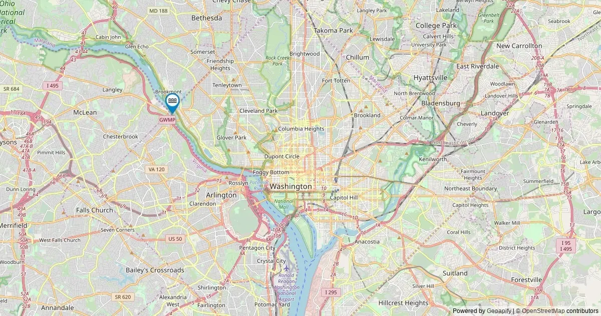
To make federal spatial data accessible to the public, cartographic researchers have converted the raw USGS GNIS database into an interactive digital map. This tool visualizes the precise point where the District’s sole recognized fall is situated, offering user-friendly functionality designed for both casual visitors and academic researchers studying regional geography.
By selecting the designated marker plotted on the interactive interface, users can open a detailed data card tailored to that specific geographic feature. Each interactive popup window provides essential information drawn directly from federal archives, including the official name of the waterfall, the county-equivalent jurisdiction in which it resides, and its precise geographic coordinates.
Beyond basic identification, the mapping tool integrates functional navigation features. The interface includes direct driving directions that route users toward the closest established roadway access point near the feature. Additionally, every record includes a deep link connecting directly to the original USGS GNIS archival record. This direct link allows users to inspect the primary historical documentation, official place-name identification numbers, and federal categorization criteria that legitimize the entry within the national catalog.
Waterfalls in District of Columbia by the Numbers
From a statistical standpoint, the District of Columbia presents a unique dataset within the United States. With just one officially named fall recorded in the federal registry, the District ranks 50th nationwide among U.S. states and territories evaluated by the USGS.
This numerical tally reflects the strict criteria required for a natural feature to receive an official name within federal archives. While local terrain may feature small unnamed streams, minor drops, or temporary water flows following weather events, the federal tally isolates only those features that have attained formal recognition through established naming protocols. As a result, the single cataloged fall stands as the definitive, federally recognized representation of the District’s natural waterfall features.
The ranking highlights the stark contrast between sprawling states with mountainous topography and smaller, highly urbanized federal districts. Nevertheless, having an established entry in the national record ensures that the District’s solitary named waterfall is preserved in land management documents, official mapping projects, and spatial analysis tools used across federal agencies.
Top Counties for Waterfalls in District of Columbia
Geographic distribution across administrative boundaries is straightforward within the District of Columbia due to its single municipal and county-equivalent structure. The administrative breakdown demonstrates that the solitary cataloged fall resides entirely within the District of Columbia itself.
Because the District operates as a unified federal territory and single county-equivalent entity, no other municipal or county subdivisions exist to split the tally. District of Columbia County leads and completes the list with a total count of one named fall, leaving no secondary jurisdictions or competing regional tallies.
This concentrated spatial footprint simplifies public land tracking and resource management. Environmental cataloging within this single jurisdiction ensures that federal and local spatial databases align seamlessly when tracking water features, land preservation zones, and public access pathways associated with the recorded landmark.
Notable Named Waterfalls in District of Columbia
The selection of named falls cataloged by the USGS reflects specific geographic and historical designations established over generations. The official federal mapping system tracks features that carry distinct, recognized names that have been formally submitted to or adopted by the U.S. Board on Geographic Names.
The interactive map reflects every single entry recorded within the federal database for the District, ensuring that no official feature is omitted. While larger states contain hundreds of named cascades varying from grand drops to minor mountain runs, the District’s catalog highlights how even a solitary feature can maintain cultural and geographic significance within national mapping databases.
Federal identification ensures that the historical name associated with this feature remains standardized across all official publications, educational resources, and cartographic products. By compiling this information into a accessible digital layout, researchers can study how named natural features persist even within heavily developed urban environments.
Frequently Asked Questions
How many waterfalls are there in the District of Columbia?
The USGS GNIS records exactly one named waterfall within the District of Columbia. Federal geographic analysts note that while the official count stands at one, the true physical number of water drops in the region is higher when accounting for unnamed seasonal cascades, minor trickles, and temporary runoff flows that emerge after heavy rainfall. However, the figure of one represents the official federal tally of falls that are permanent and prominent enough to carry an established, recognized place-name in national records.
Which county has the most waterfalls in the District of Columbia?
District of Columbia County holds the lead with the area’s single named waterfall, followed by no other jurisdictions. Because the District functions as a single county-equivalent geographic area, the entire regional total is contained within this single boundary. The full administrative breakdown confirms that no surrounding subdivisions exist within the District’s legal borders to divide the cataloged feature count.
Are these District of Columbia waterfalls accessible to visit?
Most named waterfalls across the country, including the feature cataloged within the District of Columbia, are situated on publicly accessible lands. These often include national parks, state or municipal park networks, Bureau of Land Management tracts, or local government properties. However, certain natural features nationwide may lie on private property or tribal lands, which carry distinct access rules and privacy protections.
Visitors planning to travel to cataloged features are urged to consult the relevant land management agency or local authority prior to embarking on a trip to confirm current access regulations and avoid trespassing on private holdings. Navigation links provided within map popups typically route drivers to the nearest public roadway or parking facility. Reaching the actual site of the waterfall may then require walking or hiking along designated trails, depending on local terrain and conservation guidelines.
When is the best time to visit District of Columbia waterfalls?
For the District of Columbia and the surrounding mid-Atlantic region, peak water flow generally occurs during the spring season as snow melts upstream and seasonal rainfall increases. Viewing conditions are also optimal following periods of sustained heavy rain, which recharge local tributaries and enhance water volume over natural rock ledges.
Conversely, late summer and early autumn usually bring lower overall water volume. However, visiting during these drier months often yields clearer water flow and offers the added visual appeal of surrounding autumn foliage. In higher-elevation regions across the broader geographical zone, winter conditions can cause water drops to partially freeze, creating dramatic ice formations along the rock faces.
Where does this data come from?
The primary source for this mapping initiative is the USGS Geographic Names Information System (GNIS), which has served as the official federal standard for U.S. place-name designation since its establishment in 1890. The dataset was retrieved by querying The National Map’s ArcGIS REST service in May 2026, specifically isolating all geographic features classified under the official feature designation of Falls within the District of Columbia’s administrative boundaries.
It is important to note that the federal GNIS database focuses primarily on geographic location, naming history, and administrative placement rather than physical dimensional measurements. Consequently, GNIS records do not include specific waterfall heights or structural classifications. For detailed physical measurements, vertical drop calculations, and volumetric statistics, researchers and outdoor enthusiasts must cross-reference federal spatial data with specialized repositories such as the World Waterfall Database.
More District of Columbia Maps
The cataloging of the District’s single named waterfall forms part of a broader ongoing effort to map and digitize the natural and historical features of the nation’s capital. By leveraging public geographic information systems (GIS), spatial analysts continue to build comprehensive cartographic tools that illustrate the unique intersection of urban infrastructure, public parks, and natural hydrology within the federal territory.
These spatial resources allow users to examine the District’s physical landscape through verified data layers, providing a reliable foundation for geographic education, land use planning, and environmental conservation across the region.