In an industry where spatial data processing has traditionally required specialized desktop installations or data transfers to remote servers, QuickMapTools has introduced a browser-native alternative designed to execute everyday geographic information system tasks directly on local devices. Utilizing WebAssembly technology, the platform enables GIS professionals, developers, cartographers, and analysts to inspect geospatial datasets, convert between formats, transform spatial coordinates, and execute complex geometry operations without launching desktop GIS suites or uploading files over external networks.
The platform addresses a fundamental workflow challenge in spatial data management: executing lightweight spatial manipulations quickly without the overhead of heavy software or security risks associated with third-party web converters. Users can execute standard spatial operations—such as buffering GeoJSON geometries, clipping GeoTIFF raster layers, or reprojecting vector boundaries—directly within their web browser. By relying on WebAssembly, QuickMapTools compiles high-performance computational code to run natively inside the browser engine, delivering processing performance comparable to local desktop tools while keeping the user interface lightweight and accessible.
A defining feature of the QuickMapTools platform is its focus on local data privacy and security. In traditional web-based spatial utilities, users are frequently required to upload vector files, elevation models, or imagery to external cloud servers where the backend processing occurs before the output file can be downloaded. QuickMapTools eliminates this requirement by carrying out all processing client-side. Geographic data loaded into the interface remains within the client device’s local browser sandbox, ensuring that confidential, proprietary, or privacy-restricted spatial datasets never travel across third-party networks or sit on external cloud infrastructure.
The choice to run all processing locally provides direct operational benefits for organizations working under strict data governance regulations. Government agencies, utility providers, urban planning departments, and private enterprise firms often deal with sensitive spatial assets—including confidential property records, critical utility infrastructure locations, environmental assessment boundaries, and personal location records. Uploading these datasets to unverified cloud services can create compliance risks or violate data security protocols. By running entirely within the local web browser, QuickMapTools gives professionals a secure method to inspect and manipulate sensitive spatial files without compromising organizational security boundaries.
In addition to compliance and security benefits, client-side execution removes bandwidth constraints that commonly bottleneck web-based spatial workflows. When working with large spatial datasets, uploading raw data to a distant server and downloading the processed results can consume significant time and network resources. By eliminating the network transfer phase, QuickMapTools processes datasets as quickly as the local hardware can compute the underlying spatial algorithms. This approach allows users to perform instant file checks, format conversions, and geometry adjustments regardless of network connectivity or speed.
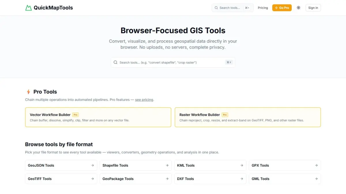
QuickMapTools provides comprehensive support across a broad range of standard vector and raster geospatial file formats. The platform reads and converts legacy formats as well as modern open standards, including ESRI Shapefiles, GeoJSON, Keyhole Markup Language (KML), GPS Exchange Format (GPX), GeoTIFF raster imagery, OGC GeoPackage databases, Drawing Exchange Format (DXF), and Geography Markup Language (GML). This multi-format capability allows users operating across different disciplines—such as web development, surveying, civil engineering, and geographic research—to convert data between incompatible systems without installing specialized file translation tools.
The ability to process multi-file formats such as Shapefiles and database structures like GeoPackages directly inside the browser represents a practical advantage for everyday spatial tasks. Despite being decades old, the Shapefile format remains widespread across government and corporate GIS databases, yet its multi-file structure can make web visualization and light editing inefficient. QuickMapTools simplifies interactions with these legacy files while maintaining compatibility with modern standards like GeoJSON and GeoPackage, which have gained rapid adoption due to their open structures, flexibility, and efficiency in web applications.
For raster data workflows, the software’s support for GeoTIFF files allows users to handle dense spatial grids and satellite imagery. GeoTIFFs, which store geo-referenced elevation models, aerial photos, and remote sensing imagery, are known for their substantial file sizes and resource-intensive processing needs. Running raster manipulation tasks such as spatial clipping directly through browser-based WebAssembly allows users to crop large imagery files or extract specific geographic areas of interest without loading full-featured image processing or remote sensing software.
The inclusion of domain-specific formats—such as GPX for field tracking, DXF for computer-aided design (CAD) systems, and GML for standardized spatial data exchanges—makes QuickMapTools a versatile link between distinct software ecosystems. Architectural and engineering teams working with CAD software can convert DXF drawings into geographic formats for web mapping, while GIS analysts can easily ingest raw GPX logs captured by field workers without running multi-step desktop conversions.
Beyond format conversion, QuickMapTools integrates coordinate transformation functionalities to resolve spatial reference discrepancies. Because spatial data is captured across different coordinate reference systems, map projections, and spatial datums, aligning mismatched datasets is a routine challenge in cartography and spatial analysis. The platform allows users to reproject vector layers and spatial files on the fly, ensuring that datasets recorded in regional projected systems or global geographic coordinates can be brought into alignment for visualization and processing.
The web platform also provides fundamental spatial analysis tools, including vector geometry buffering. Buffering creates defined proximity zones around point, line, or polygon features, which is a standard procedure in spatial planning and environmental assessment. GIS analysts use buffers to measure setback distances around structures, mark environmental protection zones along water bodies, compute service coverage radiuses around infrastructure, or analyze spatial proximity to transport corridors. Offering these capabilities inside a browser allows users to conduct quick spatial queries without opening heavy desktop software.
QuickMapTools operates under a freemium model designed to serve both casual users and specialized spatial practitioners. The core set of features—including file viewers, format converters, coordinate transformation tools, and basic geometry operations—is available for free. This gives students, researchers, cartographers, and developers access to essential daily utilities without subscription requirements or software installation hurdles.
For users managing more complex processing environments, QuickMapTools offers a Pro tier that introduces chained vector and raster workflow pipelines. Rather than executing conversions, reprojections, and spatial buffers as isolated manual steps, the Pro pipeline enables users to link multiple spatial operations into automated workflows. This capability allows spatial analysts to streamline multi-step data processing jobs—such as taking an incoming Shapefile, reprojecting its coordinates, generating a vector buffer, clipping an overlapping GeoTIFF raster, and exporting the final dataset into a single GeoPackage—all within an automated sequence executed client-side inside the web browser.
QuickMapTools was created by Daniel O’Donohue, a geospatial specialist who is widely known in the spatial technology community as the voice and creator behind The MapScaping Podcast. Drawing from years of professional experience as a geospatial specialist using location technology to analyze geographic systems, O’Donohue developed the platform to address common friction points encountered by practitioners across the GIS community. His experience producing content and discussing industry trends with geospatial experts highlighted the growing demand for fast, browser-accessible, privacy-focused spatial utilities.
The platform’s release reflects a broader technological evolution within geographic information science, marked by a gradual shift toward browser-native, decentralized computing environments. As modern web standards and WebAssembly capabilities continue to mature, web applications are increasingly able to perform complex computational tasks that previously required dedicated desktop installations. By combining desktop-grade processing performance, strict client-side data privacy, and broad file format support, QuickMapTools offers a flexible utility for handling everyday spatial data operations directly
within the modern web browser.