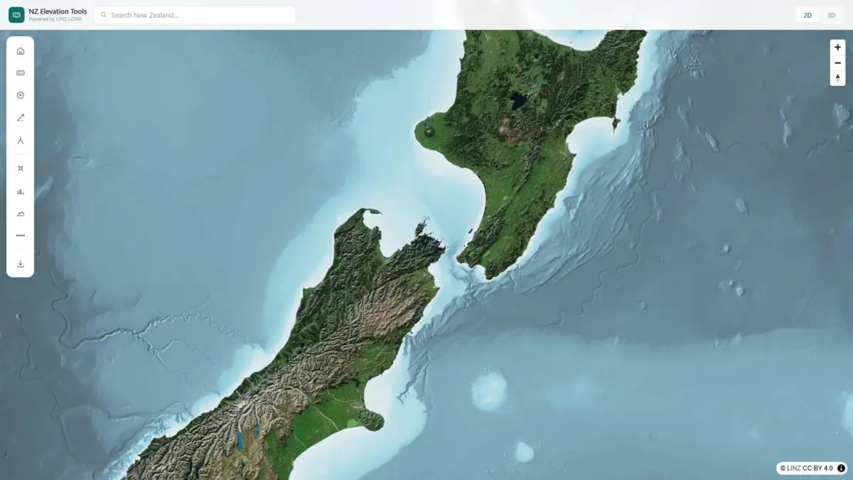
A web-based spatial application known as NZ Elevation Tools has launched, offering a lightweight and immediate gateway to New Zealand’s national land elevation datasets. By integrating Land Information New Zealand’s (LINZ) nationwide Light Detection and Ranging (LiDAR) imagery—the most detailed elevation data ever gathered across the country—the application transforms complex spatial information into an interactive, real-time mapping experience accessible directly within a standard web browser. The platform enables users to perform exact point-elevation queries, generate real-time terrain profiles, and seamlessly alternate between two-dimensional orthographic maps and full three-dimensional terrain visualizations without requiring specialized software installations or high-end desktop hardware.
The underlying foundation of NZ Elevation Tools relies on the official elevation framework maintained by Land Information New Zealand. Over recent years, LINZ has spearheaded a comprehensive national survey effort utilizing airborne LiDAR technology to map the country’s diverse physical landscape. LiDAR system instrumentation works by emitting high-frequency laser pulses from an aircraft toward the Earth’s surface and measuring the precise time it takes for those pulses to reflect back to the sensor onboard. This process captures millions of individual data points, mapping ground elevation, canopy structures, and physical landforms with exceptional vertical accuracy. The resulting dataset represents an unprecedented spatial record of New Zealand’s complex geography, encompassing everything from low-lying coastal plains and agricultural basins to the rugged, glaciated ridges of the Southern Alps.
While the LINZ LiDAR collection represents a monumental asset for national infrastructure and environmental analysis, raw elevation datasets have historically presented significant accessibility challenges for non-GIS specialists. Traditional elevation files—often delivered as dense digital elevation models, digital surface models, or massive point cloud datasets—typically require specialized Geographic Information System software such as QGIS or ArcGIS to process and render. Furthermore, working with nationwide elevation rasters demands considerable local storage space and computational processing power, effectively isolating high-resolution spatial insights from field workers, remote operators, and everyday outdoor enthusiasts. NZ Elevation Tools addresses these technical bottlenecks by transferring the rendering workload to optimized web technologies, allowing users to stream and interrogate nationwide terrain layers on demand without pre-loading massive files or configuring complex desktop applications.
At the core of the NZ Elevation Tools user interface is a streamlined set of practical measurement features designed to deliver immediate quantitative terrain metrics. Users navigating the map viewer can click on any coordinate across the New Zealand landmass to instantly retrieve an exact elevation reading. Rather than providing rounded topographic estimates or interpolated visual approximations, the tool queries the high-resolution LINZ elevation grid directly, providing reliable, absolute heights above sea level. In addition to single-point elevation checks, the viewer includes an intuitive terrain profile engine. By drawing a line across any vector on the map—whether following a proposed roadway, a farm boundary, a steep ridgeline, or a backcountry trail—the application instantly computes and renders a continuous cross-sectional elevation profile. This profile highlights changes in slope, vertical rise and fall, and terrain gradients along the selected path in real time.
To complement its quantitative measurement tools, NZ Elevation Tools provides continuous toggling between two-dimensional planimetric maps and fully interactive three-dimensional terrain models across the entire country. The 2D view offers a clear overhead perspective ideal for spatial orientation, distance measurement, and broad geographic contextualization. When switched to 3D mode, the viewer transforms the flat map into a dynamic relief model, allowing users to pan, tilt, pitch, and rotate the virtual camera around mountain ranges, river valleys, and coastal cliffs. This three-dimensional rendering capability enables users to intuitively grasp landscape geometry, evaluate shadow profiles, inspect slope steepness, and understand structural landforms that might appear flat or obscured on standard two-dimensional topographic maps.
The release of this web-based spatial tool offers distinct operational advantages across a wide range of professional sectors in New Zealand. For land surveyors and civil engineers, access to rapid in-browser elevation metrics streamlines early-stage site assessments and conceptual design workflows. Before conducting expensive on-site field surveys or setting up complex desktop GIS projects, survey technicians and engineering consultants can utilize the application to perform initial slope evaluations, inspect potential earthwork requirements, check drainage corridors, and analyze sightlines across candidate development sites. The ability to quickly extract continuous terrain profiles along proposed utility routes or access roads provides an immediate, reliable sense of vertical landscape variations during initial feasibility studies.
In the agricultural sector, where New Zealand’s varying topography plays a direct role in land utility and operational safety, NZ Elevation Tools delivers functional spatial intelligence for farmers, pastoralists, and agricultural advisors. Understanding true elevation and land slope is critical when planning irrigation layouts, designing surface water runoff management systems, laying out fence lines, and constructing livestock tracks across steep or broken country. Farmers navigating steep high-country properties can evaluate slope gradients to identify potentially dangerous machinery terrain, assess natural drainage patterns during wet seasons, and map out optimal routes for stock movement. By replacing rough height estimates with exact LiDAR-backed elevation measurements, agricultural operators can make better-informed land management decisions directly from their office or mobile devices.
Beyond commercial and technical sectors, the map viewer caters directly to New Zealand’s extensive community of trampers, hikers, and outdoor recreationists. Navigating New Zealand’s wilderness often involves traversing notoriously rugged, steep, and rapidly shifting mountain terrain where accurate elevation data is vital for safety and trip preparation. Hikers planning multi-day traverses through national parks or remote backcountry routes can draw profile lines along scheduled trails to evaluate total vertical gain, descent steepness, and peak heights. By analyzing exact terrain profiles ahead of time, trampers can accurately estimate trip duration, assess physical demand, identify challenging climbs, and pinpoint potential high-mountain pass crossings. The interactive 3D visualization further allows outdoor enthusiasts to virtually preview complex alpine topography, identifying terrain features like bluffs, valleys, and narrow saddles before stepping onto the trail.
For backcountry hunters operating in challenging wilderness environments, understanding micro-topography is equally essential. Hunters in New Zealand frequently navigate dense native bush, steep ravines, and high alpine basins where visibility is limited and terrain awareness is critical. Using NZ Elevation Tools, hunters can study ridge elevations, locate glassing positions overlooking valleys, evaluate line-of-sight clearing zones, and assess safe access and egress routes through difficult country. The ability to verify exact heights and review cross-sectional elevation profiles along valleys and ridgelines aids hunters in planning stalk routes, understanding game movement along elevation bands, and navigating unfamiliar terrain safely under varying weather conditions.
NZ Elevation Tools was created and brought to light by Daniel O’Donohue, a geospatial specialist widely recognized as the creator and voice behind The MapScaping Podcast, a prominent podcast dedicated to spatial technology, location intelligence, and geographic analysis. Drawing from years of professional experience as a geospatial specialist focused on utilizing spatial techniques to unravel complex real-world data, O’Donohue developed the application to make sophisticated geographic data accessible and useful to broader audiences. The project reflects a broader movement within the geospatial industry toward data democratization—stripping away proprietary software hurdles, heavy data downloads, and complex file formats to deliver immediate spatial value to users across diverse disciplines.
The technology underlying NZ Elevation Tools mirrors modern developments in Web GIS performance and spatial data distribution. Historically, rendering nationwide high-density LiDAR data on the web caused significant latency, often overwhelming web browsers due to memory and processing limitations. Recent advances in client-side rendering engines, GPU-accelerated web graphics, tile-based data streaming, and efficient data compression now permit massive elevation datasets to render smoothly over standard internet connections. By hosting optimized tiles of the national LINZ LiDAR coverage and leveraging the processing capabilities of modern web browsers, the tool ensures high-speed interactivity, enabling rapid panning, zooming, profiling, and mode switching without lag or performance degradation.
Ultimately, NZ Elevation Tools bridges the gap between high-precision government spatial data and practical, everyday decision-making. By making the most detailed elevation dataset ever captured for New Zealand freely accessible through a streamlined web browser interface, the platform empowers surveyors, engineers, farmers, trampers, hunters, and spatial enthusiasts alike to replace educated guesses with absolute spatial accuracy. Whether used to evaluate civil engineering corridors, plan agricultural infrastructure, or prepare for challenging mountain expeditions, the application highlights how modern web mapping can unlock the full value of national spatial data infrastructure for anyone needing to know the real height of the land.