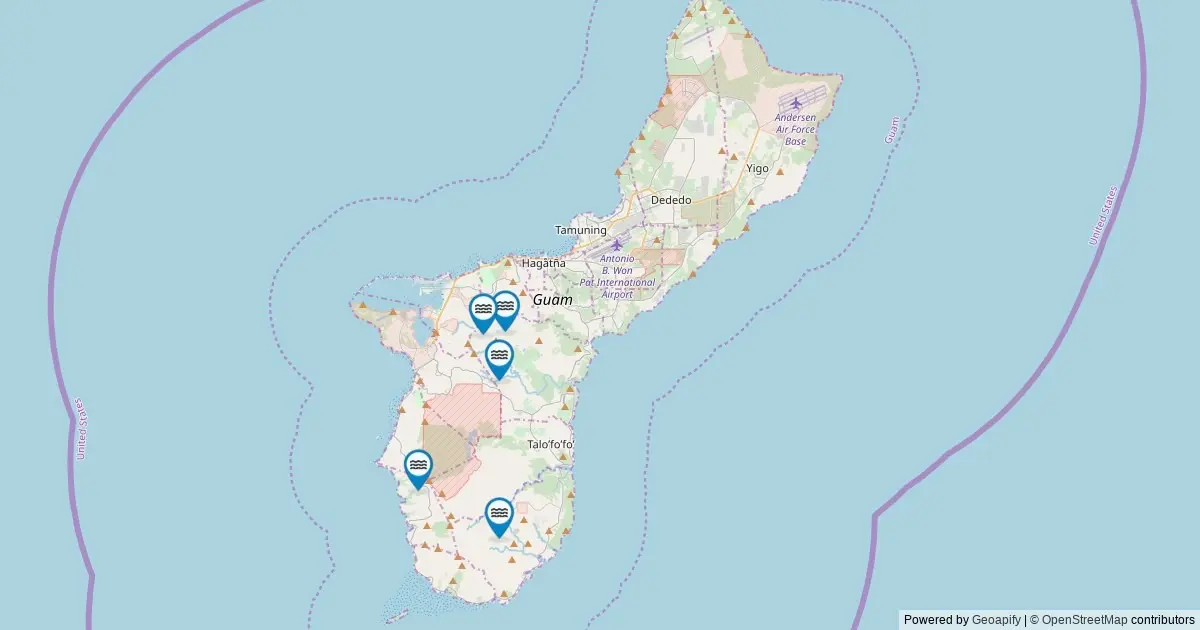
A comprehensive analysis of federal geographic data has cataloged seven officially named waterfalls across Guam, establishing a definitive mapping record for the territory’s recognized hydrological features. According to data retrieved from the U.S. Geological Survey’s Geographic Names Information System, Guam ranks 40th nationally among U.S. states and territories in total number of named waterfalls.
The dataset provides a complete spatial overview of Guam’s officially designated falls, offering precise location coordinates, administrative classifications, and direct access to federal place-name records. The cataloging effort reflects ongoing federal work to standardize geographic naming conventions and map natural landforms across all U.S. jurisdictions using unified spatial frameworks.
While seven falls are formally registered in the federal database, land managers and cartographers note that the physical landscape contains additional seasonal cascades that lack formal naming recognition. The seven cataloged features represent the official benchmark recognized by the U.S. Board on Geographic Names.
How to Use This Guam Waterfalls Map
The spatial distribution of Guam’s named waterfalls has been visualized using interactive cartographic tools driven by official U.S. Geological Survey (USGS) data. Each mapped point corresponds to a feature classified specifically under the "Falls" category within the federal database.
Users navigating the digital map can select individual feature markers to reveal detailed attribute records. Interactive popups display the official name of the fall, its assigned county-equivalent jurisdiction, exact latitude and longitude coordinates, and auto-generated driving directions to the closest accessible roadway point.
Furthermore, each entry includes a direct link to the corresponding record within the USGS Geographic Names Information System (GNIS). These deep links allow researchers, land managers, and outdoor enthusiasts to examine official historical entries, federal feature IDs, and related cartographic metadata maintained by the federal government.
Waterfalls in Guam by the Numbers
From a statistical standpoint, Guam’s total of seven named waterfalls places it in the lower tier of U.S. states and territories evaluated by federal topographers. Ranking 40th nationally, the territory’s catalog reflects both its concentrated geographic footprint and its distinct tropical terrain.
Despite its modest position in national volume rankings, the complete mapping of these seven natural features offers an exhaustive account of the island’s permanently designated waterfalls. National rankings derived from the GNIS registry rely exclusively on features that have undergone formal naming processes, providing a standardized metric for nationwide spatial comparisons.
The numerical inventory highlights how federal geographic indexing categorizes island territories alongside mainland states. By tracking named features across all regions, federal agencies maintain consistency in environmental monitoring, search-and-rescue mapping, and resource management protocols.
Top Counties for Waterfalls in Guam
Under the administrative structure utilized by the U.S. Census Bureau and federal cartographic agencies, Guam is designated as a single county-equivalent entity. Consequently, the regional distribution of the territory’s named waterfalls is consolidated entirely within one jurisdiction.
Guam County accounts for all seven named waterfalls listed in the official federal database. Unlike larger states divided into dozens of distinct county jurisdictions, Guam’s entire inventory of cataloged falls resides within this single administrative boundary.
This administrative consolidation simplifies spatial tracking for federal datasets. Every named waterfall recorded on the island falls under the same territorial land management frameworks and federal geographic coding systems, ensuring uniform record-keeping across all seven official features.
Notable Named Waterfalls in Guam
The seven named waterfalls cataloged by the USGS represent a diverse array of geographic features scattered across the island’s terrain. Each named fall carries a distinct place name recognized by local tradition and formal federal documentation.
These features have been documented by topographers over decades of spatial surveys. The inclusion of a fall on the official GNIS roster indicates that its name has been vetted and accepted by federal mapping authorities for use on official topographies, nautical charts, and government publication materials.
The complete geospatial record mapped from the federal database encompasses every single one of the seven recognized falls. By examining individual records, researchers can analyze the geographic clustering of these named water features across the island’s landscape.
Frequently Asked Questions
How many waterfalls are there in Guam?
The official U.S. Geological Survey GNIS database records exactly seven named waterfalls within Guam. While the total number of physical water drop-offs and seasonal streams across the island is higher during periods of heavy rain, seven represents the official federal count of falls that carry an established, recognized name.
Which county has the most waterfalls in Guam?
Guam County holds the entirety of the territory’s named waterfalls, leading with all seven cataloged falls. Because the island operates as a single county-equivalent unit in federal mapping systems, no other county divisions exist within the dataset.
Are these Guam waterfalls accessible to visit?
Accessibility varies depending on specific land ownership and management policies. Most named falls in Guam are situated on publicly accessible lands, including territorial parks, federal reservations, or local government properties. However, certain falls or access routes cross private land or restricted tracts, where specific access rules apply. Visitors are advised to consult local land managers prior to visiting, respect property boundaries, and adhere to posted regulations. Driving directions mapped in the dataset lead to the nearest public road, with many falls requiring a subsequent short or moderate hike along established trails.
When is the best time to visit Guam waterfalls?
Water flow across Guam’s falls varies primarily based on seasonal precipitation patterns. Peak volume generally coincides with periods of heavy rainfall during the wet season, when runoff fills inland channels and creates robust displays. During drier months, stream volumes decrease, often resulting in lower flow rates but clearer water conditions along trail approaches.
Where does this data come from?
The underlying data originates from the USGS Geographic Names Information System (GNIS), which has served as the official federal standard for U.S. place names since its establishment in 1890. The dataset was extracted by querying The National Map’s ArcGIS REST service in May 2026 for all features classified as "Falls" within Guam. While GNIS maintains official geographic names and location coordinates, it does not record physical structural dimensions such as waterfall height or width; secondary databases like the World Waterfall Database track those specific physical metrics.
More Guam Maps
The mapping of Guam’s seven named waterfalls is part of a broader effort to digitize and make accessible federal spatial data for the territory. GIS technology and open-data web services maintained by federal agencies allow researchers to integrate waterfall location data with topographic layers, hydrological surveys, and administrative boundaries.
Geospatial analysts utilize these mapped records to study watershed distribution, soil erosion patterns, and natural drainage networks across the island. By linking historical place-name registries with modern satellite mapping tools, federal and local agencies maintain an accurate spatial framework for environmental planning and public information.