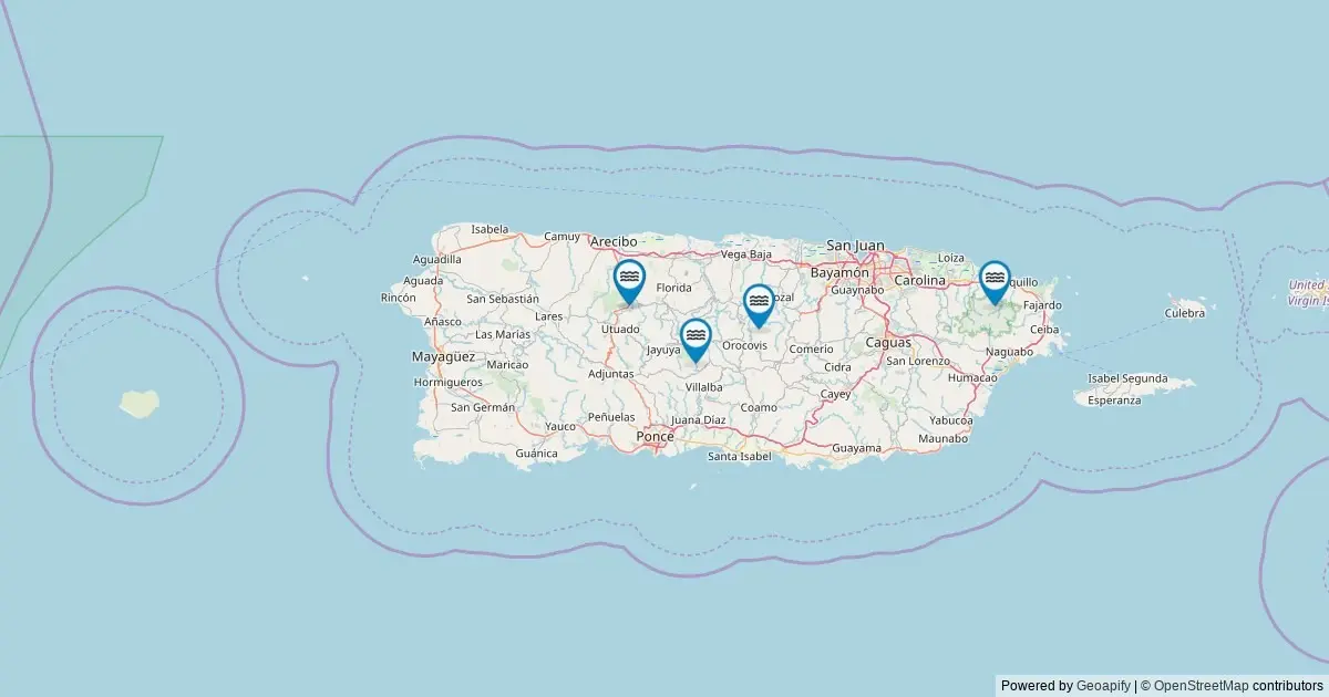
A comprehensive analysis of federal cartographic records reveals that Puerto Rico is home to six officially named waterfalls, placing the island territory at 44th nationally in the catalog of federally recognized water drops across U.S. states and territories. The data, sourced from the U.S. Geological Survey’s Geographic Names Information System, provides a standardized inventory of the island’s named hydrologic features, mapping their exact geographic coordinates, municipal locations, and administrative records.
While the island’s tropical climate and mountainous interior foster numerous rivers and seasonal cascades, federal record-keeping distinguishes between unnamed environmental water flows and officially recognized features. The cataloged entry of six waterfalls reflects features that meet strict historical, cartographic, and administrative standards established by federal geographic authorities over more than a century of survey work.
Mapping Puerto Rico’s Named Falls Through Federal Cartographic Data
The systematic cataloging of geographic features across the United States and its territories relies on the Geographic Names Information System, which has served as the official federal standard for U.S. place names since its establishment in 1890. To compile the definitive index of Puerto Rico’s waterfalls, cartographers and researchers queried The National Map’s ArcGIS REST service, capturing every record explicitly designated under the feature classification of "Falls" within the island’s boundaries.
Digital mapping projects utilizing this dataset plot each of the six named features precisely according to their USGS coordinates. These interactive cartographic tools allow researchers, land managers, and outdoor enthusiasts to select individual markers to retrieve detailed geographic profiles. Each profile includes the waterfall’s official federal name, its corresponding municipality, exact latitude and longitude coordinates, driving directions to the nearest accessible public roadway, and a direct digital link to the underlying USGS GNIS record.
By integrating geographic information system data with accessible public mapping platforms, the inventory bridges the gap between raw federal archives and practical spatial visualization. The system provides a consistent reference frame for regional planners, environmental scientists, and visitors seeking to understand the spatial distribution of Puerto Rico’s named hydrologic landmarks.
Geographic Distribution Across Municipal Boundaries
The distribution of officially named waterfalls in Puerto Rico is concentrated across five primary municipalities, reflecting the island’s varied topography, which ranges from steep mountain ridges to coastal river basins. Unlike some larger mainland states with extensive river systems spanning dozens of counties, Puerto Rico’s cataloged features are clustered within specific high-elevation and forested zones.
Río Grande leads the island in the official federal count, hosting two cataloged named waterfalls within its administrative boundaries. Situated in the northeastern region of Puerto Rico, Río Grande encompasses significant mountainous terrain and heavy annual precipitation patterns that feed coastal-bound river networks, contributing to the establishment of officially designated falls in federal cartographic surveys.
The remaining four cataloged waterfalls are distributed evenly across four separate municipalities, with each containing a single officially named feature in the federal registry:
Corozal, located in the north-central hills, contains one cataloged named waterfall. The area’s rugged landscape and natural drainage basins support established river channels that have earned formal recognition in federal geographical records.
Arecibo, spanning a vast region along the northern coast and extending inward into the island’s karst region, accounts for one named waterfall. The region’s unique geological formations and subsurface water channels create distinct surface drops that have been formally recorded by federal surveyors.
Utuado, situated within the central mountainous interior, holds one named waterfall in the official inventory. Surrounded by deep valleys and high peaks, Utuado’s hydrological network features dramatic topography that gives rise to notable water drops.
Orocovis, located near the geographical center of the island along the high elevation of the Cordillera Central, contains one officially cataloged named waterfall. The municipality’s headwaters and steep ravines provide the ideal physical conditions for permanent water drops.
Together, these five municipalities account for the complete federal tally of named waterfalls in Puerto Rico, demonstrating how official place-name designations are tied to specific geographical and administrative sub-regions.
Official Federal Tallies Versus Local Hydrological Realities
A common point of confusion in cartographic reporting is the distinction between officially cataloged named features and total physical water drops. According to USGS records, Puerto Rico contains exactly six named waterfalls. However, environmental scientists and local geography experts acknowledge that the physical count of cascades across the island is substantially higher.
The discrepancy lies in the criteria required for federal inclusion. For a waterfall to appear in the GNIS database, it must carry an established, recognized name documented in historic maps, official land surveys, local government records, or published geographic literature. Countless unnamed cascades, seasonal chutes, plunge pools, and minor drops exist throughout Puerto Rico’s tropical river systems—particularly after heavy rainfall events—but remain absent from the federal tally because they lack an official proper name.
The federal count of six represents features deemed historically or geographically prominent enough to warrant standard naming. This methodology ensures nationwide consistency in federal cartography, distinguishing permanent, named landmarks from ephemeral or minor hydrological flow points.
Land Management, Property Ownership, and Public Access
Access to Puerto Rico’s named waterfalls varies depending on land ownership, environmental protections, and local infrastructure. A significant portion of the island’s cataloged falls sit on publicly managed land, including state forest reserves, municipal properties, and federal tracts such as those managed by the U.S. Forest Service within El Yunque National Forest.
Publicly accessible falls generally fall under the jurisdiction of local or federal land managers who establish guidelines for entry, trail maintenance, and environmental conservation. Visiting these locations often involves navigating public highway systems to designated access points, followed by foot travel along established trail networks. The driving directions embedded within cartographic map tools direct users to the nearest public roadway, though reaching the water features themselves may require moderate hiking through rugged forest terrain.
Conversely, certain named falls or their immediate surrounding corridors reside on private property or within restricted management zones. In these instances, entry is governed by private landowners or specific administrative agencies. Geographic records emphasize the necessity of respecting property boundaries, adhering to local regulations, and obtaining proper permission prior to entering non-public lands.
Land managers also highlight safety considerations surrounding waterfall visits. Mountainous river channels in Puerto Rico are subject to rapid fluctuations in water levels due to localized rain storms, making real-time weather monitoring and site assessment critical for safe navigation near riverbeds and plunge basins.
Hydrological Characteristics and Cartographic Data Nuances
While the USGS GNIS serves as the standard registry for geographic names, it operates under specific structural parameters. The federal system records spatial locations, administrative boundaries, historical naming origins, and feature categories, but it intentionally omits physical physical dimensions such as waterfall height, crest width, volume rate, or drop structure.
For detailed physical measurements, researchers and hydrologists refer to specialized private and academic resources, such as the World Waterfall Database, which complement federal spatial coordinates with physical measurement metrics.
The flow dynamics of Puerto Rico’s waterfalls are closely tied to regional weather patterns and elevation. Tropical precipitation patterns dictate seasonal volume, with period heavy rains producing maximum flow rates across river networks. During drier spells, water volume decreases, altering the appearance of the falls and often yielding clearer stream conditions.
In higher-elevation zones along the central mountain range, lower ambient temperatures and steep elevation drops create unique microclimates that influence local hydrologic behavior, though tropical conditions prevent the winter freezing observed in northern mainland states.
By maintaining a centralized, verified database of named features through the GNIS framework, federal agencies provide a reliable baseline for environmental monitoring, cartographic publishing, and geographic research. The public availability of this data ensures that Puerto Rico’s named waterfalls remain accurately documented within the broader national inventory of geographic landmarks.