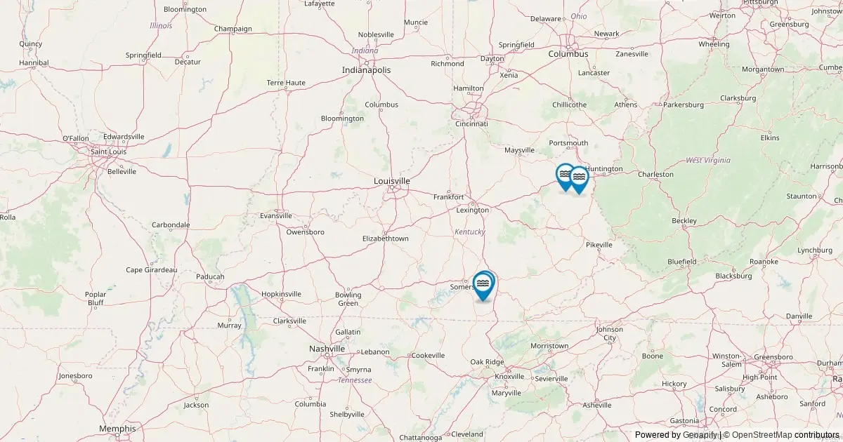
An analysis of federal geographic data has cataloged Kentucky’s officially recognized hydrologic features, placing the Commonwealth at 30th nationwide for its concentration of officially cataloged falls. According to records maintained by the United States Geological Survey, Kentucky is home to 19 named waterfalls.
While local residents and outdoor enthusiasts frequently point to a much broader array of seasonal cascades throughout the state’s varied topography, the federal benchmark establishes a concise list of 19 features significant enough to carry officially recorded names in the national gazetteer. An interactive mapping effort now consolidates these features, offering detailed spatial coordinates, land management context, and direct links to historical records.
The geographic profile draws entirely from the federal government’s primary database for spatial nomenclature, plotting every designated fall across the Commonwealth while highlighting the concentration of these natural features within specific southern and eastern counties.
How to Use This Kentucky Waterfalls Map
The spatial distribution of Kentucky’s waterfalls is rendered through an interactive mapping interface designed to provide comprehensive geographic data for researchers, land managers, and outdoor recreationists. Every named waterfall identified in federal records is marked on the map, allowing users to pinpoint locations down to exact geographic coordinates.
By selecting individual map markers, users access detailed pop-up cards containing critical metadata for each site. This information includes the waterfall’s official federal name, the specific county in which it resides, and its precise latitude and longitude.
Beyond standard spatial identifiers, the mapping system provides functional tools for field navigation. Each marker includes a direct routing link that generates driving directions to the nearest roadway access point relative to the feature. Additionally, for those seeking archival or administrative background, every popup features a deep link to the corresponding entry within the official federal record, allowing users to verify historical entries and geographic classifications.
Waterfalls in Kentucky by the Numbers
Kentucky’s total count of 19 named waterfalls positions the state at number 30 in national rankings for recognized falls. This figure reflects strict federal criteria established to document geographic features across the United States.
It is important to distinguish between the official federal tally and the total physical presence of flowing water features across the state. The figure of 19 represents features that have met the formal threshold for official naming and federal cataloging. Hydrologists and local land stewards note that the true physical count of waterfalls in Kentucky is significantly higher when accounting for unnamed seasonal cascades, wet-weather drop-offs, and localized runoff paths that form following heavy precipitation.
However, for administrative, mapping, and cartographic consistency, the count of 19 serves as the definitive baseline established by federal geographic authorities.
Top Counties for Waterfalls in Kentucky
The geographic distribution of named waterfalls across Kentucky is concentrated largely within the southeastern and eastern regions of the state, where rugged terrain and river basins create the structural conditions necessary for permanent fall formations.
Whitley County leads the Commonwealth in the total number of officially cataloged features, holding three named waterfalls within its borders. This places Whitley County at the center of the state’s waterfall geography.
Following Whitley County, McCreary County registers the second-highest concentration, containing two officially recognized named falls.
The remaining cataloged waterfalls are distributed singly across several other counties. Wayne County, Menifee County, Rockcastle County, and Carter County each contain one officially named waterfall recorded in the federal database. Together, these six counties account for the primary cluster of federally recognized falls in the state, reflecting how local geology and drainage networks influence the presence of these permanent features.
Notable Named Waterfalls in Kentucky
The 19 features recorded across the state include a selection of distinctively named falls that reflect the cultural, geographic, and historical naming conventions of their respective localities.
These notable features are fully plotted on the interactive map, which captures every single entry cataloged in the federal register. By exploring the mapped sites, users can examine how individual falls are distributed among public forests, state park lands, and remote river corridors, gaining a complete picture of the Commonwealth’s hydrographic layout.
Frequently Asked Questions
How many waterfalls are there in Kentucky?
Federal records maintained in the official national database list 19 named waterfalls within the state of Kentucky. While the true physical count of water drops across the state is higher when informal, temporary, or unnamed seasonal cascades are included, 19 remains the official federal count of falls notable enough to carry an established, recognized name.
Which county has the most waterfalls in Kentucky?
Whitley County holds the highest number of officially cataloged falls in the state, with three named waterfalls within its boundaries. McCreary County follows with two named falls, while Wayne, Menifee, Rockcastle, and Carter counties each contain one officially registered fall.
Are these Kentucky waterfalls accessible to visit?
The majority of named waterfalls in Kentucky are located on publicly accessible land. These parcels include state parks, National Forest acreage, land managed by the Bureau of Land Management, and various county or municipal public properties. However, select falls reside on private property or tribal lands, which carry specific access restrictions and permissions.
Visitors are advised to consult with the appropriate land management agency prior to planning a trip and to respect private land boundaries at all times. From a navigation standpoint, the driving directions provided in the interactive mapping interface direct travelers to the closest paved or unpaved road. From those points, accessing the falls typically requires a short to moderate hike along established trails or footpaths.
When is the best time to visit Kentucky waterfalls?
Water volume and visual characteristics vary significantly throughout the year based on seasonal weather patterns. For most waterfalls across Kentucky, peak flow rates occur during the spring snowmelt period and following heavy seasonal rainstorms, when watershed runoff is at its maximum.
In contrast, the late summer and early autumn months generally bring lower water volume. However, visiting during late summer or autumn often presents clearer water flows framed by changing seasonal foliage. During the winter months, particularly in higher-elevation areas of the state, colder temperatures cause many falls to partially freeze, creating prominent ice structures along the cliff faces.
Where does this data come from?
The underlying data for this mapping project is sourced directly from the United States Geological Survey Geographic Names Information System. Established in 1890, the database serves as the federal standard for geographic place names across the United States.
The dataset was compiled by querying the ArcGIS REST service of The National Map for all features officially classified under the feature class of "Falls" within the boundaries of Kentucky. Because federal records focus primarily on nomenclature and spatial location, the agency does not measure or maintain data regarding waterfall height or vertical drop. For specific structural metrics such as height and width, researchers typically consult specialized secondary registries such as the World Waterfall Database.
More Kentucky Maps
Detailed geographic data and spatial analysis continue to provide clear insights into Kentucky’s natural features, land management structures, and physical landscape. Further mapping resources offer expanded coverage of the Commonwealth’s environmental features, public park boundaries, and regional transportation networks.