With three-quarters of the year now behind us, climate data analysis confirms that 2026 is virtually certain to rank as either the warmest or second-warmest year in recorded history. Driven by a rapidly strengthening El Niño event compounding long-term human-caused global warming, the planet experienced its warmest August on record and its second-warmest September, cementing a continuous pattern of extraordinary global heat.
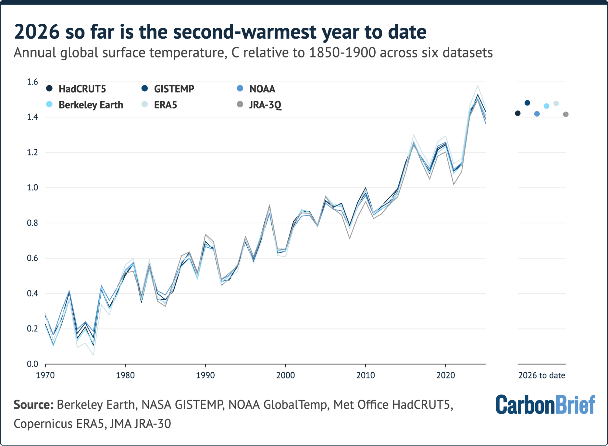
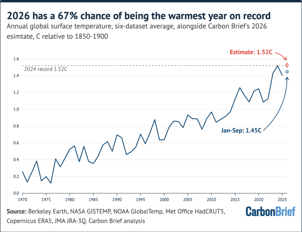
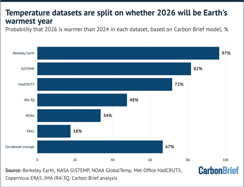
According to the latest quarterly "state of the climate" analysis, global surface temperature records maintained by multiple international research groups indicate that 2026 holds a 67% statistical chance of surpassing 2024 to become the hottest year on record across a six-dataset average. As scientists look ahead, projections suggest that the unfolding climate dynamics will push global temperatures even higher into the following year, raising urgent questions about Earth’s accelerating energy imbalance and the state of global climate thresholds.

A Record August and the Second-Warmest Year to Date
The global climate trajectory for 2026 has been tracked through comprehensive analyses of records compiled by six leading surface temperature monitoring groups, including NASA GISTEMP, NOAA, Berkeley Earth, the European Copernicus Climate Change Service (ERA5), the Japan Meteorological Agency (JRA-3Q), and the UK’s HadCRUT5.
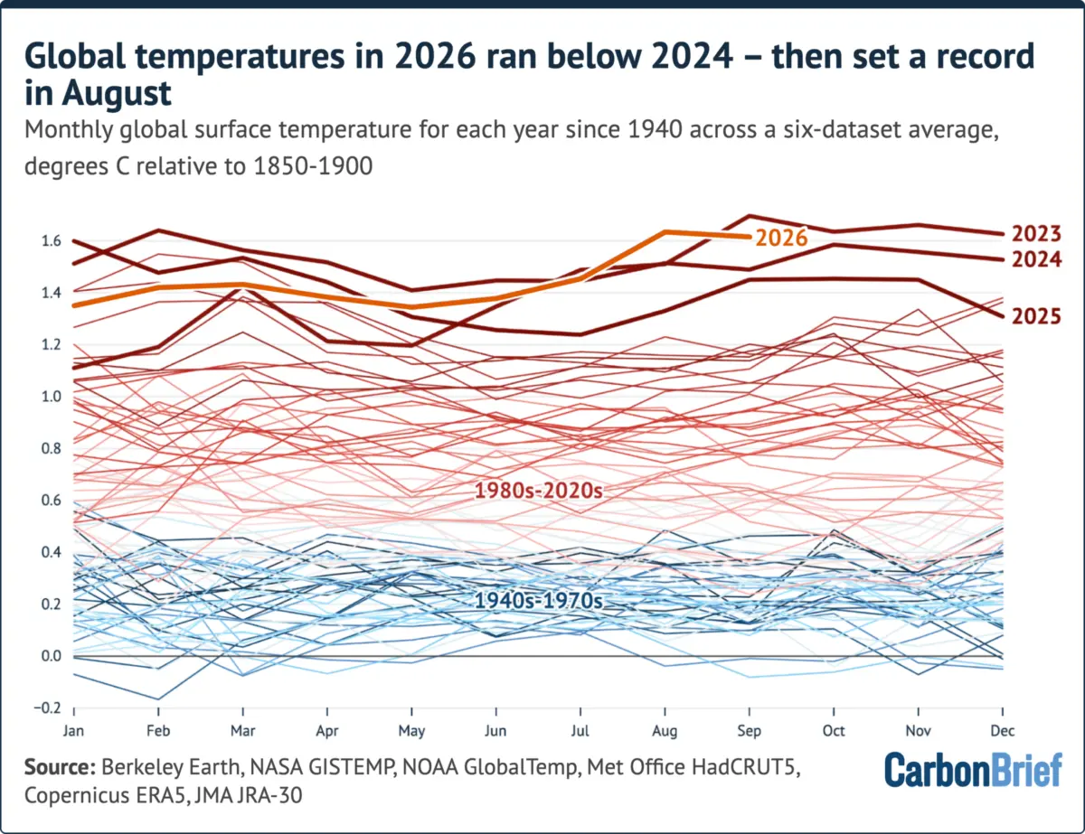
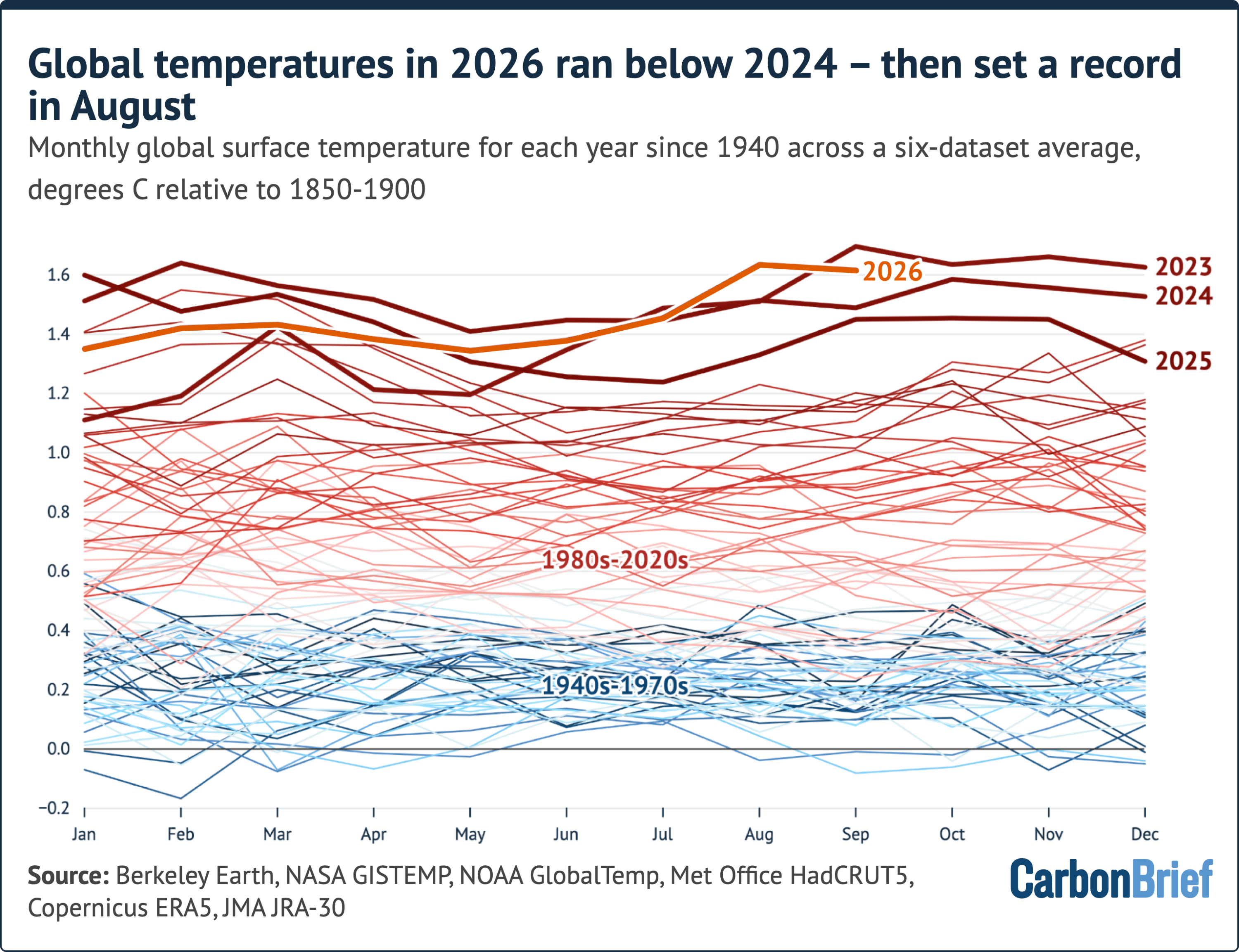
The first nine months of 2026 ranked as the second-warmest such period on record across all six datasets, trailing only the unprecedented warmth observed during the same months in 2024. The year began with a comparatively moderate pace. Every month from January through June ran slightly cooler than the corresponding months in 2024, as the lingering effects of weak La Niña conditions slowly transitioned into a developing El Niño phase.

The El Niño-Southern Oscillation (ENSO), a recurring climate phenomenon in the tropical Pacific, alternates between cool (La Niña) and warm (El Niño) phases, periodically releasing vast amounts of heat from the oceans into the atmosphere and temporarily boosting global temperatures. By the third quarter of 2026, this dynamic shifted dramatically. July marked the second-warmest July in the multi-dataset average, running neck-and-neck with July 2024. August then shattered previous boundaries, establishing a new global record for the month by an average margin of 0.12 degrees Celsius across all tracking systems. Although September experienced a slight plateau following the intense summer surge, it still registered as the second-warmest September in modern history, sitting roughly 0.08 degrees Celsius below the all-time high set in September 2023.
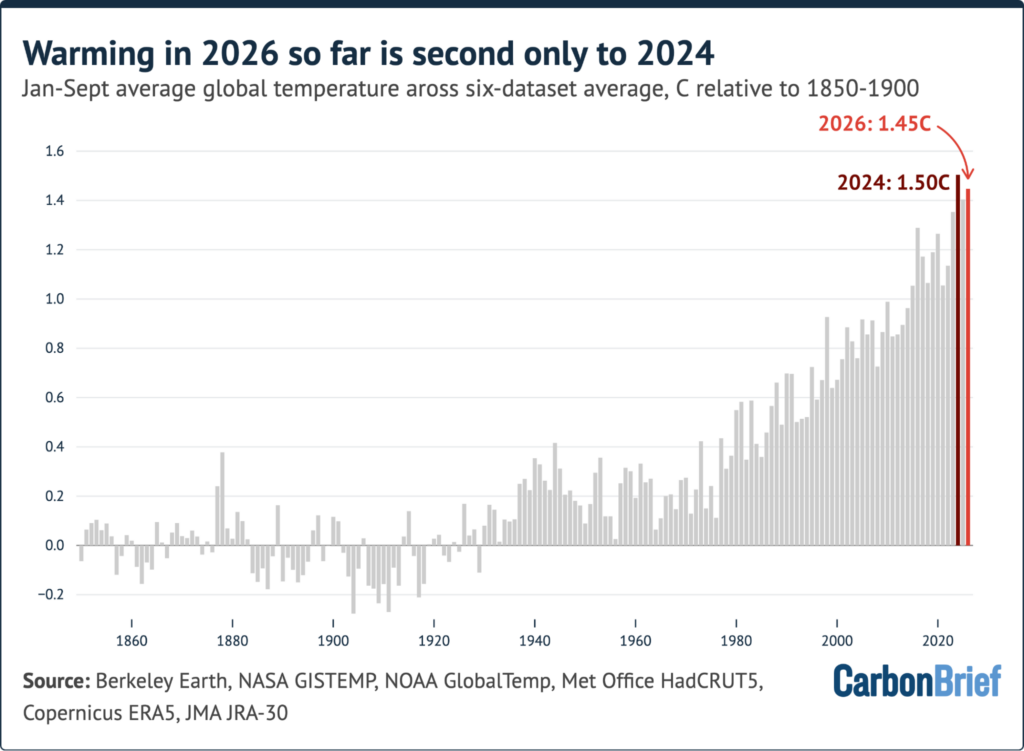
Across the broader July-to-September quarter, global temperatures tied with 2023 as the warmest three-month period on record, averaging approximately 1.57 degrees Celsius above pre-industrial levels. For the January-to-September timeframe, the global average stood at 1.45 degrees Celsius, placing it a mere 0.06 degrees Celsius behind the record pace of 2024.
A Record-Setting El Niño Event
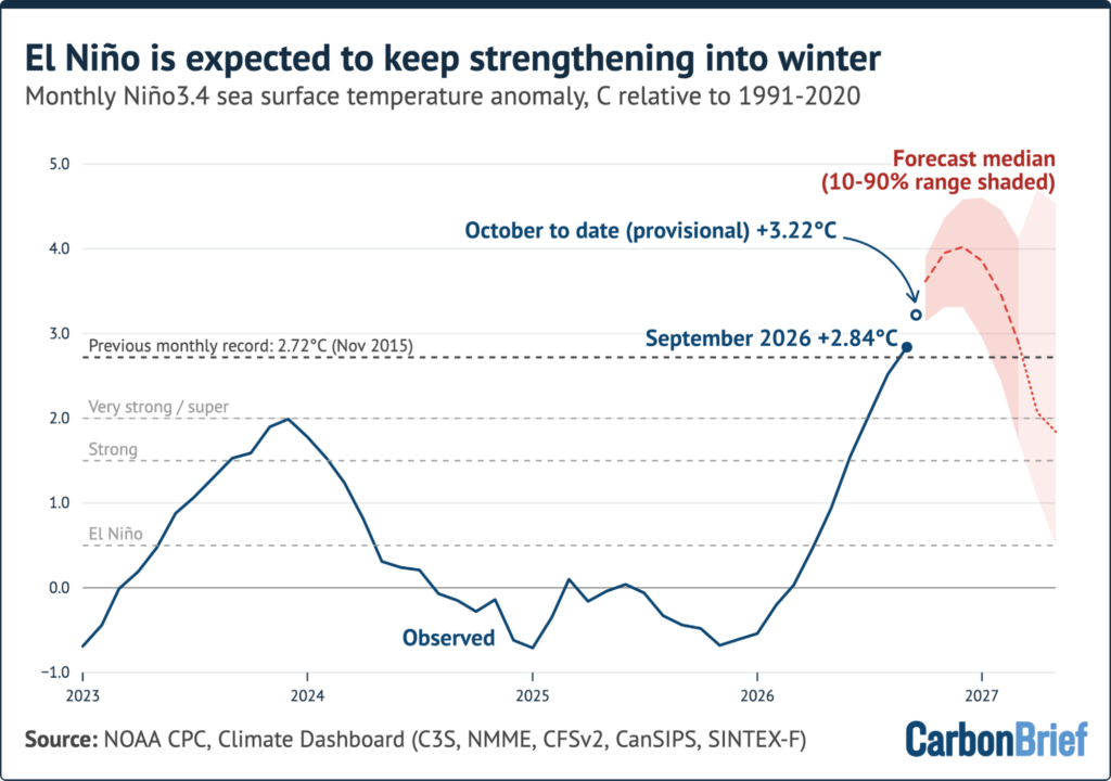
The primary driver behind the sudden acceleration in late-year temperatures is a remarkably potent El Niño event that crossed a historic threshold in September. Daily sea surface temperature anomalies in the "Niño 3.4" region of the tropical Pacific—the benchmark area used by scientists to gauge the strength of the phenomenon—surpassed the previous record set in November 2015, making it the strongest event since the modern satellite era began in 1981.
Since crossing that milestone, the current El Niño has remained above previous peak levels every single day. September recorded the highest monthly Niño 3.4 temperature anomaly since records began in the mid-19th century. By mid-October, daily values were hovering approximately 3.5 degrees Celsius above the 1996-2025 seasonal average and roughly 0.4 degrees Celsius higher than the peak observed during the strong 2015-2016 El Niño.
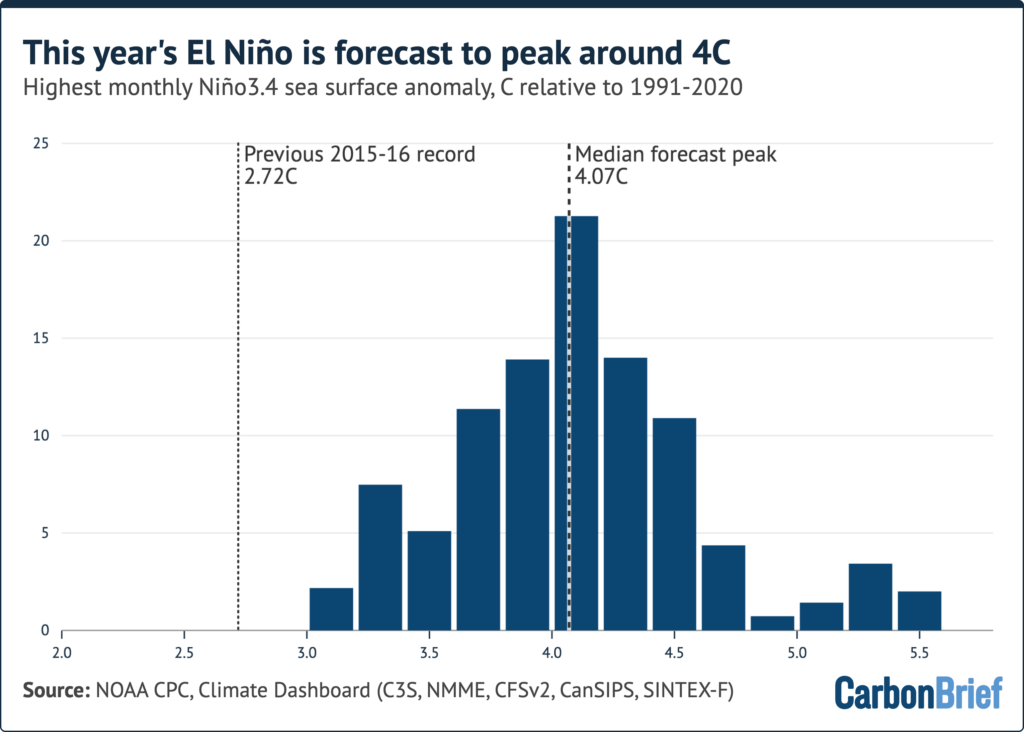
Climate models project that this phenomenon will continue to intensify through the winter months. An analysis of 656 forecasts generated by 14 different dynamical climate models indicates that the event is expected to peak around 4 degrees Celsius in December, placing it more than 1 degree Celsius above any prior recorded benchmark. Historical reconstructions utilizing proxy data such as tree rings and coral sediments suggest this could be the most powerful El Niño event in at least a millennium.
Because global surface temperatures typically lag changes in the tropical Pacific by roughly three months, an El Niño peaking at the end of 2026 will exert its maximum influence on global temperatures throughout 2027. While long-term anthropogenic greenhouse gas emissions remain responsible for virtually all foundational global warming, these short-term oceanic oscillations dictate the extreme fluctuations seen from year to year.
Record Heat Across Much of the World
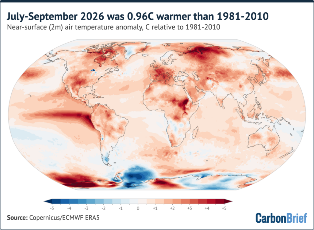
The sweeping warmth of recent months has translated into profound regional extremes. Data from the ERA5 reanalysis system shows that global temperatures for the July-to-September period were 0.96 degrees Celsius above the 1981-2010 average and 1.58 degrees Celsius above pre-industrial levels.
The thermal signature of El Niño was clearly visible across the eastern and central tropical Pacific, where surface waters off the coast of Ecuador and Peru surged to more than 4 degrees Celsius above normal. Western Europe and the Mediterranean also endured exceptional heat, with temperatures climbing roughly 3 degrees Celsius above average across France and the western Mediterranean basin. Significant warmth similarly gripped northwest Russia, the Canadian Arctic, south-central North America, eastern Africa, and parts of western Antarctica, contrasted against cooler-than-average conditions primarily confined to the Weddell Sea sector of Antarctica.
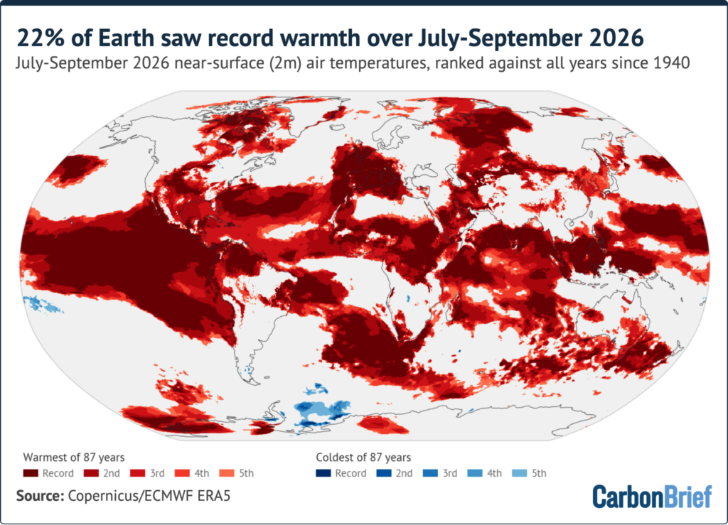
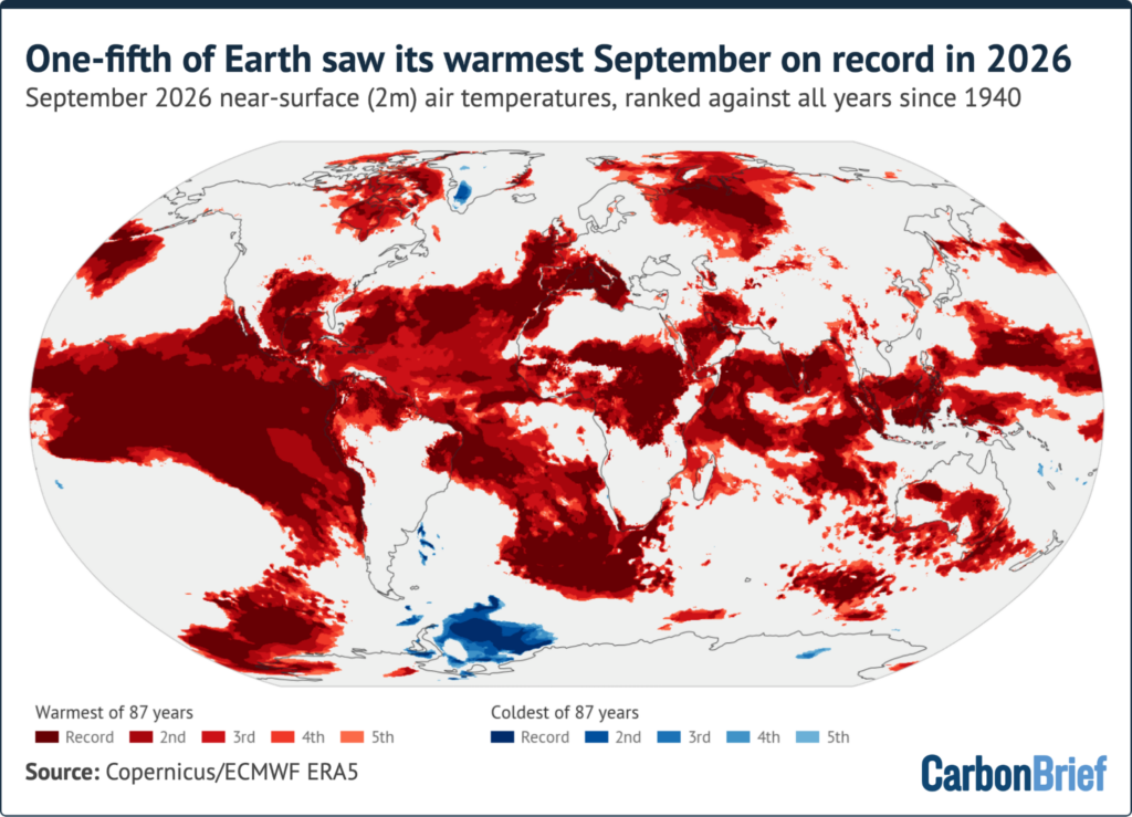
Statistical breakdowns reveal the staggering geographic scope of the heat: approximately 22% of the Earth’s surface experienced its warmest July-to-September period on record, while nearly half of the planet recorded one of its top five warmest quarters. On land, roughly 85% of France and the Iberian Peninsula recorded their hottest July-to-September on record.
National weather services reported that 55 countries established individual national temperature records during September alone, including Italy, Spain, Portugal, Colombia, Chile, Venezuela, Kenya, Nigeria, the Philippines, and the United Arab Emirates. Western Europe endured its hottest summer on record, eclipsing the previous milestone set during the historic European heatwave of 2003, with over half the continent exposed to very strong heat stress. Rivers across Europe fell to their lowest summer water flows since monitoring began in 1992, while severe drought and extensive wildfires swept across both the European Union and large swathes of the contiguous United States, which also recorded its hottest summer and September on record.
Conversely, the climatic disruptions extended to hydrological cycles elsewhere. India’s annual monsoon season, which historically weakens during El Niño periods, concluded with a 12.6% deficit in rainfall, marking the driest monsoon in 11 years. In the tropics, the El Niño pattern heavily suppressed Atlantic hurricane development while fueling a record-setting volume of tropical cyclones across the Pacific basin.
Good Odds of Being World’s Warmest Year
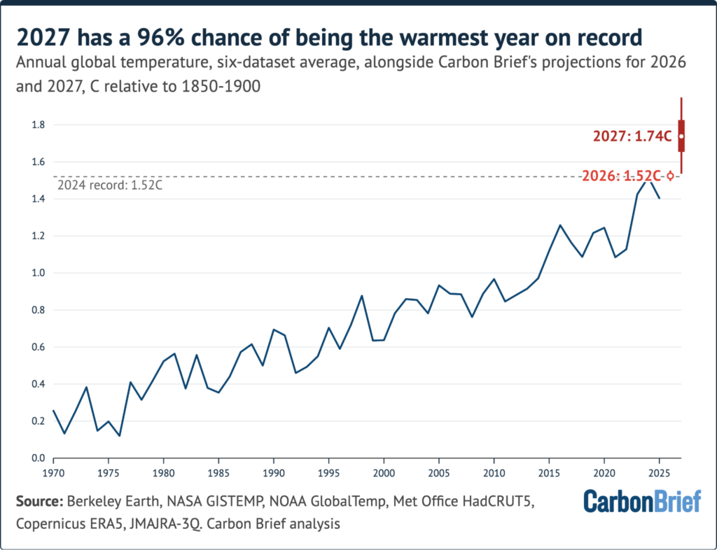
Synthesizing observed monthly temperatures with modern El Niño forecasts, statistical models project that the final global average temperature for 2026 will land approximately 1.52 degrees Celsius above pre-industrial levels, with a 90% likelihood range spanning from 1.50 to 1.55 degrees Celsius. This estimate positions 2026 in a statistical dead heat with the record established in 2024.
Current analytical models give 2026 a 67% probability of claiming the title of the warmest year on record across the combined multi-dataset average. Furthermore, the year carries a 93% chance of exceeding the 1.5-degree Celsius threshold, making it only the second year in human history—following 2024—to breach that annual marker. Climate scientists emphasize, however, that individual calendar years exceeding 1.5 degrees Celsius do not constitute a formal breach of the long-term Paris Agreement targets, which are measured over multi-decade averages.
Projections carry inherent uncertainties, particularly because the current El Niño forecasts extend beyond the historical boundaries of the observational training data. If the atmospheric response to this unprecedented oceanic warmth matches historical parameters rather than exceeding them, the odds of a new annual record remain robust at around 50% to 67%.
Datasets are Split on Whether 2026 is Headed for a Record
When international scientific institutions officially release their annual climate assessments in January, public reporting is expected to reflect a split decision among various monitoring groups.
Based on current trajectories, datasets like Berkeley Earth indicate a near-certain probability (97%) of a 2026 record, while NASA GISTEMP points to a strong likelihood (82%). Other systems, such as NOAA and the JRA-3Q reanalysis, view a record as roughly balanced, while the European ERA5 dataset places lower odds on a new benchmark due to a wider temperature gap remaining between 2026 and 2024.
These discrepancies do not imply methodological error among the research groups. Instead, they stem from differing approaches to addressing geographical data gaps—particularly in data-sparse regions like the Arctic—and variations in how sea surface temperature records are integrated. Reanalysis models like ERA5 and JRA-3Q utilize advanced weather simulation systems constrained by observational data rather than relying strictly on blended station measurements. Similar divisions occurred in early 2015, when agencies offered varying assessments of whether 2014 had claimed the global warmth record.
Looking further ahead, the compounding effect of the current El Niño means that 2027 is projected to eclipse current records by an even wider margin. Climate models estimate that 2027 has a 96% chance of becoming the warmest year on record, potentially pushing global averages to around 1.74 degrees Celsius above pre-industrial baselines. This projected jump of roughly 0.2 degrees Celsius between 2026 and 2027 would surpass any single-year temperature increase observed following previous El Niño events.
Earth’s Energy Imbalance Has More Than Doubled
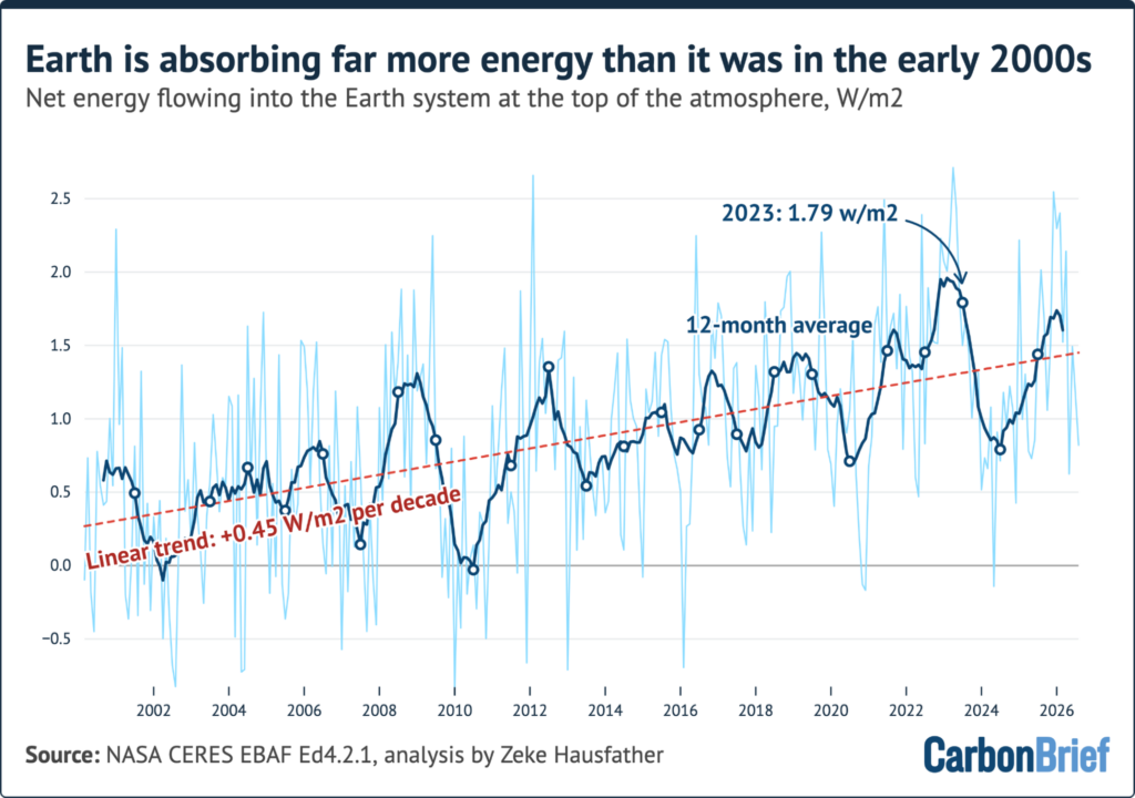
Underpinning these fluctuating annual temperature records is a fundamental and accelerating physical shift in the Earth system: the planetary energy imbalance. This metric represents the net difference between the solar radiation absorbed by the Earth and the thermal energy radiated back into space. As long as this imbalance remains positive, the planet accumulates excess heat, with approximately 90% of that thermal energy being absorbed directly into the world’s oceans.
Satellite observations from NASA’s CERES instruments, which have monitored top-of-the-atmosphere radiation since 2000, reveal that Earth’s energy imbalance has more than doubled over the past two decades. The average imbalance rose from approximately 0.53 watts per square meter during the 2000-2010 decade to roughly 1.25 watts per square meter over the most recent decade, marking a 2.4-fold increase. The highest annual energy imbalance recorded to date occurred in 2023 at 1.79 watts per square meter, while the twelve-month period ending in August 2026 averaged 1.59 watts per square meter.
While the exact mechanisms driving this accelerated accumulation of heat remain an active area of scientific research—with some studies suggesting changes in cloud cover are playing a role—the sustained positive imbalance confirms that the rate of global warming is actively intensifying.
Arctic Sea Ice Minimum Tied for 10th Lowest, Antarctic Near Record Lows
Polar ice observations for 2026 reflect the ongoing pressures of planetary warming, characterized by distinct developments in both polar regions.
In the Arctic, sea ice extent reached its annual seasonal minimum on September 12, dropping to 4.60 million square kilometers according to the National Snow and Ice Data Center (NSIDC). This minimum tied with 2008, 2010, and 2025 as the 10th lowest extent in the nearly 48-year satellite record, remaining 1.21 million square kilometers above the historic low set in 2012.
The September minimum followed an unusual trajectory earlier in the year. After a winter maximum that tied for the lowest in the satellite record, Arctic sea ice set or tied daily record lows across 39 separate days between January and early July. However, ice retreat slowed notably during the summer months, and sea ice extent remained within the historical 1979-2010 range from August onward, though it stayed well below long-term averages.
In the Southern Hemisphere, Antarctic sea ice reached its winter maximum extent on September 14 at 17.59 million square kilometers. This marked the third-lowest winter peak on record, trailing only the extreme lows observed in 2023 and 2024. Following this peak, Antarctic sea ice experienced a rapid decline, plunging to new daily record lows for much of the period through October and illustrating the continued vulnerability of polar ice systems to shifting global climate dynamics.