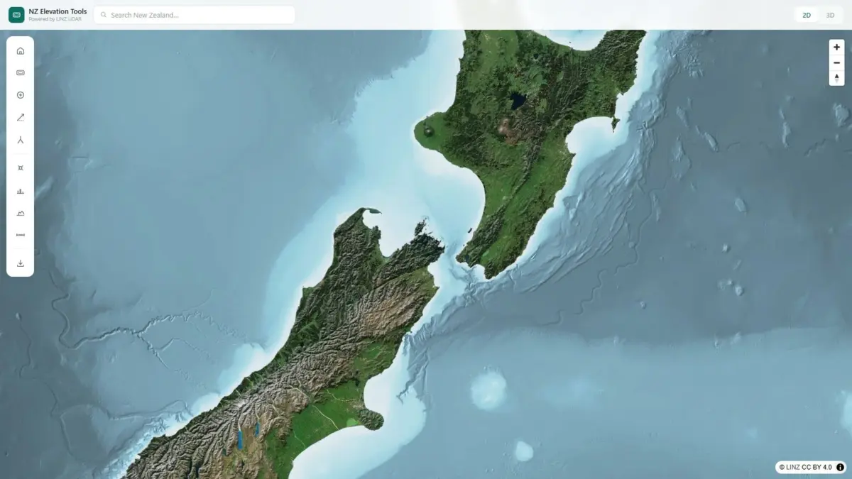
A new web-based mapping tool known as NZ Elevation Tools has brought Land Information New Zealand’s high-resolution LiDAR datasets directly into standard web browsers, enabling users across the country to interactively query and analyze topographic terrain in real time. The platform transforms complex spatial data—traditionally confined to specialized geographic information system software—into an accessible digital viewer where users can click anywhere on the map to extract pinpoint elevation measurements, draw custom lines to instantly generate terrain cross-section profiles, and seamlessly switch between two-dimensional and three-dimensional views of the nation’s varied landscape. Developed to serve both industry professionals and outdoor recreationists, the web application eliminates traditional barriers to high-precision geographic height data.
The core underlying data powering the application originates from Land Information New Zealand (LINZ), the government agency responsible for managing official land, location, and property information. LiDAR, an acronym for Light Detection and Ranging, relies on airborne laser systems to send millions of light pulses toward the earth’s surface every second. By precisely measuring the time required for reflected light to return to an airborne receiver, the system constructs hyper-detailed three-dimensional point clouds of the ground surface, vegetation cover, and built structures. Across New Zealand, LINZ has overseen comprehensive mapping programs to capture the country’s steep, dynamic topography at high density. By relying directly on these authoritative government datasets, the viewer provides users with real height measurements rather than rough approximations or lower-resolution satellite estimates across both the North and South Islands.
Historically, utilizing raw LiDAR datasets required downloading large spatial files, such as point cloud files or high-density Digital Elevation Models, which demanded significant hardware storage, high-performance computing power, and technical software skills in programs like ArcGIS or QGIS. NZ Elevation Tools circumvents these technical requirements by executing spatial data rendering directly inside the user’s browser window. Upon launching the platform, users are presented with an intuitive map viewer that pairs satellite basemaps with dedicated sidebar tools. This architecture allows spatial queries to process fluidly on standard desktop computers, laptops, and mobile devices without requiring file downloads, plugin installations, or localized rendering software.
Among the fundamental features built into the viewer is its single-click point elevation measurement system. By selecting any point on the map interface, the system references the underlying high-resolution LINZ LiDAR grid and returns an accurate surface elevation figure above sea level. This capability allows users to immediately verify real height numbers across any geographic location—from low-lying coastal flats to steep backcountry peaks—without having to read contour lines on static paper maps or estimate vertical distances from coarse aerial imagery.
In addition to point elevation queries, the application incorporates a dynamic terrain profiling feature that allows users to evaluate elevation trends across a specific distance. By drawing a line across any section of the terrain—whether spanning a mountain ridge, a valley floor, or a farm boundary—the application instantly generates a two-dimensional topographic cross-section along that drawn vector. The elevation profile reveals continuous surface variations, highlighting total vertical gain, descent, slope steepness, and local low points along the drawn path. This immediate cross-sectional visibility provides critical insight into the physical structure of the terrain, offering a clear picture of land geometry that might be overlooked on standard top-down satellite maps.
The visual interface also provides seamless transitions between orthographic two-dimensional map views and full three-dimensional terrain visual models. The two-dimensional view delivers classic top-down clarity, making it ideal for spatial orientation, distance measurement, and geographic context. Toggling to the three-dimensional viewing mode activates real-time elevation depth, allowing the user to tilt, rotate, and pan around landforms across the entire country. The 3D view accentuates vertical relief, rendering mountain ranges, river channels, coastal cliffs, and rolling hills with realistic perspective, which helps users visualize physical landforms in context.
The platform was designed to address practical requirements across several key professional fields, including land surveying, civil engineering, and agricultural management. For land surveyors and civil engineers, accurate preliminary elevation data is essential when conducting site assessments, evaluating potential road alignments, managing earthworks, and assessing runoff risks. While formal surveys remain indispensable for legal land boundaries and final engineering designs, having instantaneous browser-based access to LINZ LiDAR profiles helps technical professionals conduct early feasibility studies, analyze slope gradients, and assess physical site constraints without spending time preparing and processing massive raw spatial files.
In New Zealand’s agricultural sector, where terrain varies dramatically from flat alluvial plains to high-country hill pastures, precise height data supports farm design and environmental management. Agricultural operators, soil scientists, and land managers deal directly with issues related to soil erosion, surface water movement, pasture runoff, and irrigation infrastructure. By leveraging browser-based LiDAR viewing tools, farmers can trace natural drainage channels across paddocks, assess hill slopes to mitigate erosion, plan effective fence lines, and design gravity-fed water supply systems. The ability to pull accurate profile lines across property contours allows land managers to make practical decisions grounded in reliable topographic data.
The tool also serves non-commercial end-users, particularly outdoor recreationists navigating New Zealand’s demanding natural wilderness. Trampers and hikers venturing into steep mountain environments, national parks, and dense forests face variable weather conditions and rugged terrain where route awareness is essential for safety. Standard topographic maps rely on fixed contour intervals that can mask localized dips, small cliffs, or sudden steep drops. By drawing planned walking tracks in the viewer beforehand, trampers can evaluate exact elevation profiles, evaluate continuous slope angles, and calculate expected vertical climbs before heading into the backcountry.
For backcountry hunters operating in unmanaged wilderness areas, terrain visualization directly influences navigation, safety, and line-of-sight planning. Navigating steep gullies, evaluating ridge crossings, and assessing physical travel corridors across dense bush or alpine tops are central to hunt preparation. Using the 3D viewing capabilities and cross-sectional profile line tools, hunters can analyze mountain features, measure ridge heights, identify potential natural barriers, and choose safe access and exit routes across unfamiliar terrain before setting out.
The platform was created by Daniel O’Donohue, a geospatial specialist who is also the creator and voice behind The MapScaping Podcast, a widely recognized audio show focused on geographic information systems, spatial analysis, satellite imagery, and location-based technologies. Drawing on his professional background as a geospatial specialist, O’Donohue built the web application to help bridge the gap between high-value open-access spatial datasets and everyday end-users who need quick, reliable geographic insights without technical friction. The initiative reflects a broader movement within the geospatial industry aimed at democratizing spatial data—making complex national datasets directly accessible and functionally useful to non-specialists through modern web technology.
By providing direct web accessibility to Land Information New Zealand’s official LiDAR datasets, NZ Elevation Tools demonstrates how public spatial infrastructure can be made accessible for everyday practical use. As high-definition LiDAR mapping continues to support critical national applications—ranging from flood hazard mapping and natural hazard resilience to forestry management and regional infrastructure planning—web-based viewing tools ensure that high-accuracy elevation data remains readily available to professionals, land managers, and outdoor enthusiasts throughout New Zealand.