
Blue Marble Geographics has officially introduced a comprehensive new subscription model for its flagship Global Mapper software, marking a major shift in how geospatial professionals access, manage, and deploy essential mapping technology. The updated licensing structure brings previously fragmented geospatial tools, advanced terrain analysis functions, lidar processing capabilities, and photogrammetry workflows together into a unified and streamlined product offering.
By transitioning away from the company’s traditional perpetual licensing model and separate maintenance contracts, Blue Marble Geographics is modernizing its software delivery to align with contemporary enterprise needs. The new framework introduces annual, named-user subscriptions divided into three distinct tiers: Essentials, Advanced, and Professional. Each tier has been carefully tailored to provide specific mapping and data processing capabilities scaled to the diverse requirements of GIS practitioners, surveyors, engineers, and geospatial analysts. Furthermore, all three subscription levels include continuous software updates, dedicated technical support, comprehensive training resources, and centralized administrative license management designed to reduce friction for organizations of all sizes.
The structural evolution of the software ecosystem comes at a pivotal time for the geospatial and commercial drone industries. As spatial data grows increasingly complex and volumes of high-resolution lidar and photogrammetric data multiply, professionals require flexible tools that can adapt seamlessly to shifting project scopes. The new subscription tiers allow organizations to procure precisely the level of functionality they require, ensuring that teams are neither under-equipped for demanding workflows nor overpaying for specialized modules that fall outside their operational scope.
Three Tiers for Different Mapping Workflows
The redesigned product architecture revolves around a three-tiered approach—Essentials, Advanced, and Professional—which allows users and project managers to select software tools based on the specific demands of their daily workflows.
The baseline Essentials tier caters to traditional GIS tasks, vector and raster data management, and foundational spatial data creation. Moving up to the Advanced tier introduces more sophisticated analytical capabilities, including heavy-duty terrain modeling, spatial analysis, and robust data management tools suitable for regional planning, environmental monitoring, and civil engineering projects.
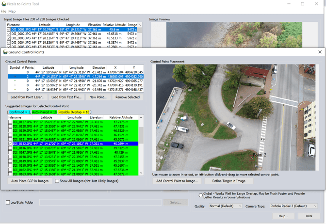
For drone mapping professionals, surveyors, and reality capture specialists, the Professional tier unlocks the most advanced and specialized capabilities within the Global Mapper ecosystem. Recent software updates integrated into this top tier introduce powerful new features designed to streamline high-volume reality modeling pipelines. These include live previews for automatic point cloud analysis, which significantly reduce processing guesswork by allowing operators to visualize point cloud classifications in real-time. Additionally, the Professional tier incorporates automated tree trunk classification—a valuable asset for forestry management, urban planning, and environmental impact assessments—alongside enhanced multispectral imagery support within the Pixels to Points photogrammetry toolset, enabling more accurate orthomosaic generation and vegetation health analysis from drone-captured imagery.
Connecting Office and Field Operations
This major product launch also forms a crucial component of Blue Marble’s broader corporate and technological strategy following its strategic combination with Avenza Systems in April 2026. The integration of Blue Marble’s robust desktop processing power with Avenza’s renowned mobile mapping expertise represents a concerted effort to bridge the traditional gap between office-based GIS processing and active field operations.
Looking ahead, future software updates are expected to substantially improve data sharing and interoperability between desktop environments and mobile devices running the Avenza Maps application. This seamless connectivity will allow field crews to collect accurate spatial data, verify desktop analyses on the ground, and sync updates back to central databases with minimal administrative friction, ultimately accelerating project lifecycles across surveying, infrastructure inspection, and emergency response sectors.
Patrick Stevenson, Chief Product Officer of Blue Marble Geographics, emphasized the operational benefits of the streamlined framework during the announcement. Consolidating the entire office workflow into a single subscription package and managing deployments through one unified administrative portal drastically reduces the administrative complexity that practitioners traditionally face when accessing, managing, and utilizing the mission-critical tools they rely on daily.
To support this unified management approach, the company has launched the Blue Marble Hub. This centralized online portal handles license management, seat assignments, software downloads, technical support resources, and training materials. To ensure subscribers continuously benefit from rapid technological advancements in the geospatial sector, Blue Marble Geographics has committed to delivering four scheduled software releases each year.
Regarding the transition for existing clients, Blue Marble Geographics has confirmed a clear pathway forward. Current customers can transition smoothly to the new subscription model at their own pace, while customers who currently hold active Maintenance and Support contracts will continue to receive uninterrupted support and updates through the remainder of their contract expiration dates.