On the morning of August 26, a catastrophic wall of water and debris tore through the rugged Himalayan border region shared by Nepal and the Chinese region of Tibet. The ensuing flash floods killed more than 1,300 people, while thousands remain missing, triggering widespread devastation that has destroyed vital infrastructure, homes, roads, and bridges across multiple river basins. In the days following the disaster, an international team of scientists has mobilized, using satellite imagery, drone footage, and seismic monitoring data to untangle the complex mechanics behind the event.
Initial reports suggested the disaster was driven by a conventional glacial collapse or an earthquake. However, researchers now understand the catastrophe as a "multi-hazard cascade," a complex chain reaction that began with a massive bedrock failure high on a mountain slope and ultimately culminated in catastrophic downstream flooding. While some climate skeptics have attempted to exploit the nuance of a bedrock collapse to argue that human-caused climate change had no bearing on the event, earth scientists emphasize a different reality. Although formal attribution studies take time, long-term atmospheric warming is unequivocally increasing the probability of such ice-rock avalanches throughout high-mountain Asia.
Researchers studying the region have highlighted how rapid, elevation-dependent warming is dramatically reshaping the Himalayas. Rising temperatures, retreating glaciers, and thawing permafrost have all been identified as critical destabilizing factors that likely contributed to the disaster. Balendra Shah, the prime minister of Nepal, described the floods as a serious signal that the risks borne by Himalayan communities are increasing sharply due to a changing climate.
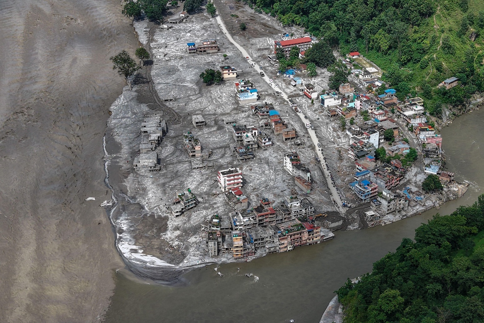
What Happened?
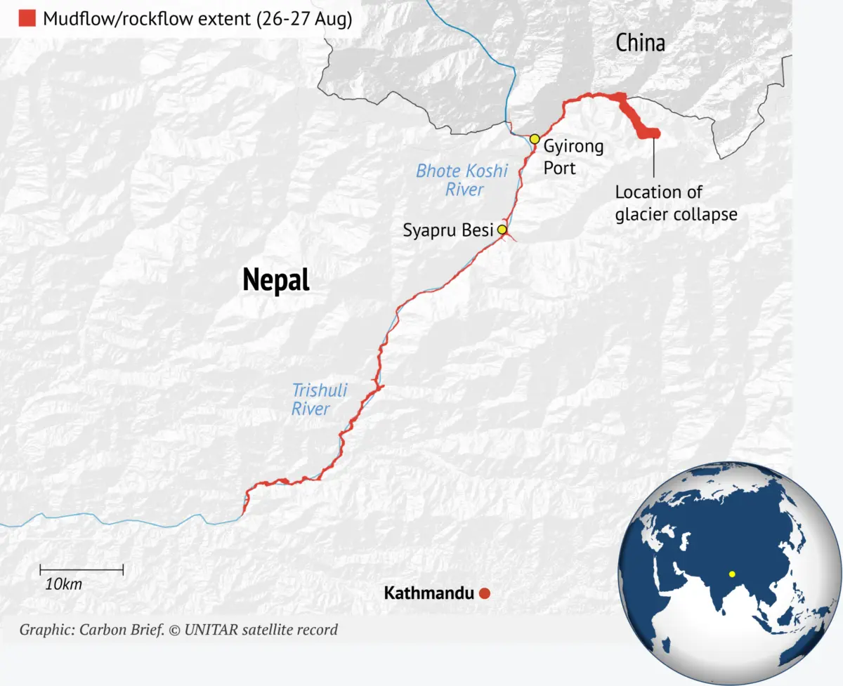
According to a detailed report published on August 28 by the HiRisk scientific consortium, a coalition of high-mountain experts, the disaster was set in motion when a massive chunk of bedrock—along with the glacier ice resting on top of it—broke away from a steep slope of the Langtang-Lirung mountain in the Nepalese Himalaya. The mass plunged from an altitude of approximately 5,200 meters above sea level straight down to the valley floor at 3,000 meters.
The sheer force of the landslide shook the ground violently. At 8:37 AM local time, the US Geological Survey initially registered a magnitude 4.4 earthquake, but later clarified that the seismic signature was actually generated by the massive glacier collapse and debris flow, with an energy release equivalent to a magnitude 5.2 earthquake.
Upon hitting the valley floor, the avalanche of melting ice, water, and pulverized rock slammed directly into the Lhende Khola, a high-altitude river tracing the border between Nepal and China. Known downstream as the Bhote Koshi in Nepal and the Poiqu or Poqu in China, the waterway feeds an extensive network of rivers, including the Trishuli.
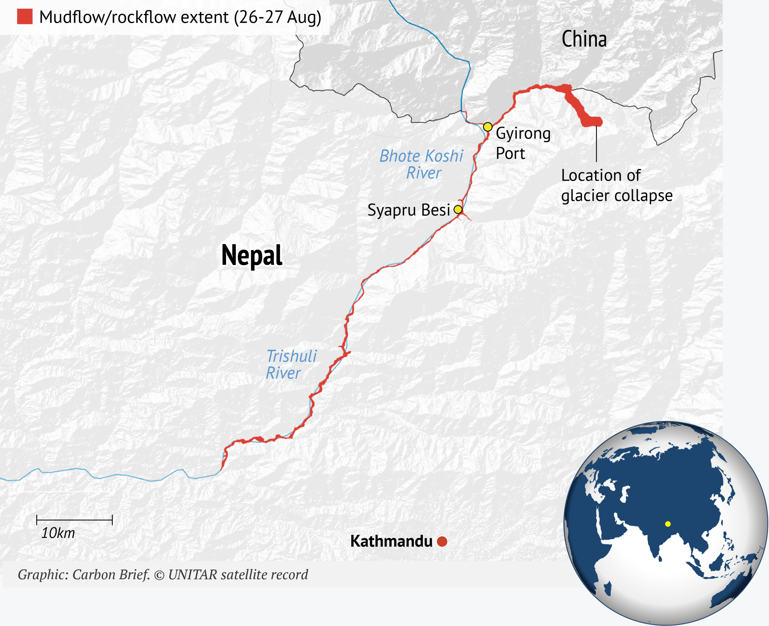
The impact temporarily formed a massive debris lake on the valley floor. When this natural dam inevitably burst, a terrifying wall of water and rock surged downstream at speeds reaching up to 30 kilometers an hour, equivalent to roughly 19 miles per hour. The floodwave reached Mugling, a Nepalese town more than 130 kilometers downstream, by approximately 1:00 PM local time. Separate reports from the Center for Land Surface Hazards in the United States noted that the flood was exceptionally fast, sediment-laden, and extreme in scale, pointing out that in the Nepalese municipality of Galchhi, the Trishuli river rose by an astonishing nine meters in just 30 minutes.
Writing in The Conversation, Dr. Umesh Haritashya, a glaciologist at the University of Dayton in Ohio, emphasized that the disaster did not end with the initial wall of water on August 26. A secondary barrier lake, estimated to hold several million cubic meters of water, subsequently formed where two rivers meet in Tibet before crossing into Nepal. When this secondary lake burst on August 28, water levels surged once again, compounding the misery for downstream communities.
The economic toll of the disaster is staggering. Dharma Raj Upreti, the chief of Nepal’s National Disaster Risk Reduction and Management Authority, stated that property and infrastructure losses amounted to at least $2.5 billion. Repairing and rebuilding roads, establishing temporary shelters, restoring drinking water supplies, and rehabilitating power infrastructure is projected to cost an additional $53 million.
How Did Bedrock Collapse Trigger the Flash Floods?
In the immediate aftermath of the disaster, early reports pointed toward a collapsing glacier or a tectonic earthquake. However, high-resolution satellite imagery later revealed that an enormous chunk of the mountainous bedrock underneath the glacier had given way first.
Dr. Kristen Cook, a geomorphologist at the Université Grenoble Alpes in France, noted that the underlying rock collapse was far larger than initial satellite views could capture. Dr. Jakob Steiner, a geoscientist at the University of Graz in Austria, explained that the glacier did not fail on its own; rather, the mountain beneath it collapsed, forcing the glacier to plummet because it was sitting directly on top. While the precise trigger remains under investigation, scientists attribute the failure to mechanical stress accumulating within the rock material over long periods.
Failures of bedrock—the solid rock underlying looser surface materials and soil—are becoming an increasingly common occurrence in warming mountain ranges. Professor Bethan Davies, a glaciologist at Newcastle University, points out that massive landslides frequently follow rapid deglacierization. Similar catastrophic events occurred during the Chamoli disaster in the Indian Himalaya in 2021 and the Blatten landslide in Switzerland, as well as recent incidents in Alaska.
While some climate skeptics have used the shift in focus from melting surface ice to bedrock mechanics to falsely claim that climate change played no part in the disaster, scientists argue that the distinction misses the broader picture. Fundamentally, Davies notes, the tragedy would have been far less severe if the event had been restricted to a dry rock-slope failure alone. The initial landslide incorporated a mixture of rock and ice into a valley containing buried ice, generating the hyperconcentrated, mud-laden flow that ultimately claimed over a thousand lives.
How Have Temperatures Risen in the Affected Region?
While global average temperatures have risen by roughly 1.4 degrees Celsius since pre-industrial times, planetary warming is far from uniform. High-altitude regions are experiencing accelerated climate shifts that far outpace the global average.
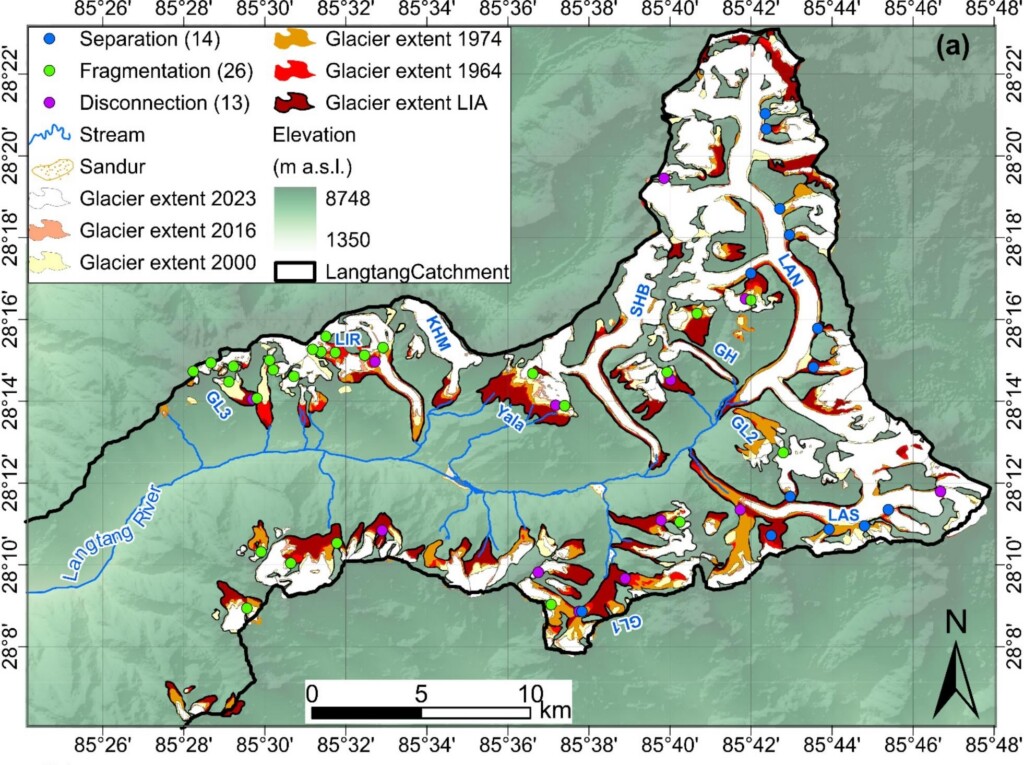
A study published in Global and Planetary Change investigated changes within the Langtang catchment, a river basin in central Nepal that houses the Langtang-Lirung mountain and where glaciers cover roughly a quarter of the land area. The research revealed that glacial zones situated at 4,000 meters above sea level warmed at a rate of 0.31 degrees Celsius per decade between 1960 and 2023, a rate more than three times higher than that observed at lower-elevation weather stations.
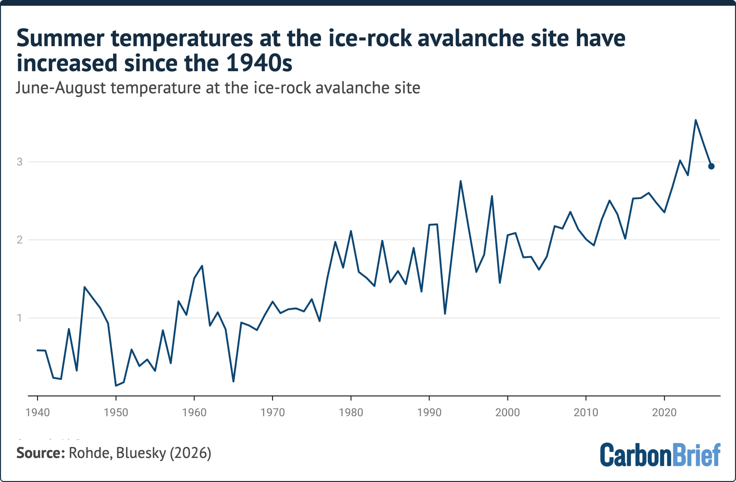
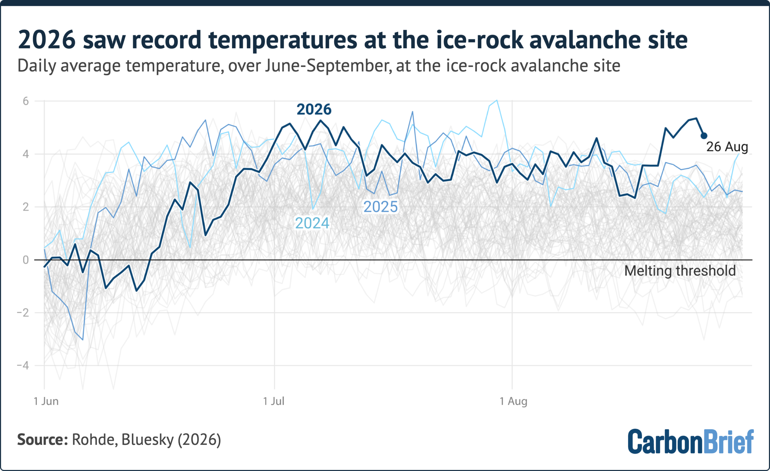
Examining the specific site of the collapse, Dr. Robert Rohde, chief scientist for Berkeley Earth, utilized ERA5 reanalysis data to trace temperature trends at the 5,200-meter elevation point where the avalanche originated. Rohde’s analysis demonstrated that summer temperatures from June to August have been steadily climbing at the site since 1940. Summer 2026 recorded the fourth-warmest conditions on record, trailing only 2024, 2025, and 2022. Furthermore, the days immediately preceding the disaster marked the hottest August temperatures ever recorded at the location. Rohde noted that given this persistent warming trend, the glacier had likely been thinning and weakening for years or even decades before failing during one of the warmest weeks in its recorded history.
How Have Rising Temperatures Affected Mountain Stability?
Experts have firmly linked regional warming trends to the degradation of permafrost—ground that has remained frozen for at least two consecutive years, with thicknesses ranging from a single meter to over a kilometer. Steiner, who has monitored regional permafrost using sensors since 2014, noted that thawing has been occurring actively at elevations of 5,200 meters for many years.
As permafrost thaws, previously solid ground transitions during warm seasons into a patchwork of frozen and unfrozen sections. This creates differential densities and internal movements that make the slope highly susceptible to mechanical failure. Davies explains that permafrost acts as a natural adhesive binding rock faces together; as it melts, the structural integrity of the rock weakens. Furthermore, the thaw generates trapped water from both melting permafrost and overlying glacial meltwater, introducing intense hydraulic pressure into rock joints and facilitating catastrophic slope failure. A recent study examining rock and ice avalanches across High Mountain Asia found that more than two-thirds of such events originated in areas where permafrost is likely present.
How Have Glaciers Retreated in the Affected Region?
Glaciers are exceptionally vulnerable to a warming climate. In the Himalayas, the rate of glacier retreat has doubled since the late 20th century. Research in the Langtang catchment showed that glacier area loss rates increased more than fourfold between 1964 and 2023, with melting accelerating sharply after 2000 alongside widespread thinning and fragmentation.
Professor Maria Shahgedanova of the University of Reading noted that the specific glacier involved in the disaster had retreated by approximately 450 meters between 1990 and 2020. This significant retreat likely reduced the mechanical support the glacier provided to the underlying rock slope, leaving the upper rock faces unstable. The International Centre for Integrated Mountain Development has repeatedly warned that shrinking glaciers across the Hindu Kush Himalaya region threaten the safety of nearly two billion people by escalating risks such as glacial lake outburst floods. While this particular event was not triggered by a GLOF, climate change continues to heighten the frequency and severity of such hazards.
Can the Event Be Attributed to Climate Change?
In the wake of the flash floods, climate campaigners, media organizations, and regional politicians immediately pointed to human-caused climate change as the driving force. However, many climate scientists urge caution, noting that exact causes take time to unravel, particularly in remote and unmonitored high-mountain areas.
When evaluating the role of human influence on extreme weather, researchers rely on attribution science. To date, no formal rapid attribution study has been completed to quantify the precise contribution of climate change to the Langtang-Lirung disaster. Studies examining similar past events, such as the 2021 Chamoli avalanche, concluded that individual disasters cannot be singularly blamed on climate change in isolation. Instead, researchers emphasize that atmospheric warming and corresponding cryospheric changes are systematically increasing the frequency and probability of high-mountain slope instabilities.
Writing on the Climate Brink publication, Dr. Zeke Hausfather noted that a definitive single-event attribution for complex rock-ice avalanches may never be fully possible due to messy causality. Nonetheless, the overwhelming consensus within the scientific community points toward warming as a primary factor increasing the likelihood of such disasters in the Himalayas. Steiner observed that while bedrock failures have occurred in the region for millennia, the changing climate dramatically elevates the probability of these events happening in close succession by driving the long-term deterioration of mountain stability. Davies reiterated that while single events have multiple drivers, it is increasingly difficult to ignore the pervasive influence of a rapidly warming climate on fragile mountain ecosystems.