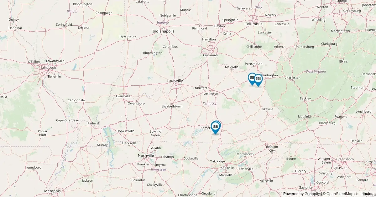
FRANKFORT, Ky. — A comprehensive analysis of federal geographic data reveals that Kentucky is home to 19 officially named waterfalls, placing the Commonwealth at 30th nationwide in federal waterfall tallies. Based on cartographic records compiled by the United States Geological Survey through its Geographic Names Information System, the dataset provides an authoritative catalog of the state’s established falling-water features. While Kentucky’s diverse terrain contains numerous unnamed cascades and temporary wet-weather drops that flow after heavy rains, federal geographers maintain official records only for features that carry an established, recognized place name.
To make these geographic records widely accessible, digital cartography resources now map every cataloged fall across the state. By compiling spatial data directly from federal archives, these interactive mapping platforms allow users to examine individual features, access precise geographic coordinates, identify county jurisdictions, obtain driving directions to entry points, and navigate directly to official federal records.
Federal Standardization and Mapping Methodology
The foundational data for Kentucky’s waterfall catalog originates from the Geographic Names Information System, which has served as the official federal standard for domestic geographic place names across the United States since its establishment in 1890. Maintained by the U.S. Geological Survey in partnership with the U.S. Board on Geographic Names, the system standardizes the spellings, locations, and official designations of natural and cultural features nationwide.
The current state inventory was established by querying The National Map’s ArcGIS REST service in May 2026, specifically isolating all natural features categorized under the feature class designation of "Falls" within the state boundaries of Kentucky. This federal classification requires that a feature possess a recognized, named identity in historical or contemporary usage to be indexed within the database.
Understanding the scope of the federal system helps clarify why the official state count stands at 19. Kentucky’s actual physical landscape contains significantly more flowing drops and cascades than the official tally suggests. The state’s extensive karst topography, sandstone arches, and dense river networks give rise to hundreds of seasonal runoff channels, unindexed trickles, and temporary bluffs that spill water during wet months. However, because these secondary features lack formally documented place names recognized by federal cartographers, they remain outside the official Geographic Names Information System registry.
Additionally, the federal database focuses primarily on geographic identification rather than physical dimensions. The system records names, county locations, geographic coordinates, and topographic map associations, but it does not measure or publish physical structural metrics such as vertical drop height, shelf width, or volumetric discharge. For physical height measurements and structural classifications, hydrographic researchers and outdoor enthusiasts must consult specialized external resources, such as the World Waterfall Database.
Geographic Distribution and Top County Rankings
An analysis of the federal data demonstrates that Kentucky’s 19 named waterfalls are primarily concentrated within the eastern and southeastern portions of the Commonwealth, where the rugged topography of the Appalachian Plateau and the Daniel Boone National Forest creates ideal geological conditions for dramatic stream drops.
Whitley County holds the distinction of leading the state in named waterfall density. Situated along the southern border of the state, Whitley County contains three officially named waterfalls within its boundaries, the highest total of any single county in Kentucky. The county’s steep elevation changes, sandstone caprocks, and active river basins contribute to its status as the top-ranked jurisdiction for cataloged falls.
McCreary County ranks second overall in the state inventory, containing two officially recognized named waterfalls. Located adjacent to Whitley County along the Tennessee border, McCreary County shares a similar geological profile characterized by deeply dissected plateaus, sandstone cliffs, and protected forest corridors that foster stable waterfall formations.
Several other counties across Kentucky each account for a single named waterfall within the federal system:
- Wayne County: Located directly west of McCreary County, containing one officially cataloged named waterfall.
- Menifee County: Situated in eastern Kentucky within the Red River Gorge region, holding one named fall.
- Rockcastle County: Located along the transition zone between the Bluegrass region and the Cumberland Plateau, documenting one named waterfall.
- Carter County: Positioned in northeastern Kentucky, featuring one officially recognized named waterfall.
The remaining named waterfalls in the 19-fall inventory are distributed individually across other rural and mountainous counties. This distribution pattern highlights how localized geology—specifically the intersection of hard, erosion-resistant caprock layers over softer underlying shale or limestone—dictates where permanent, named waterfalls develop across the state.
Land Ownership, Access Protocols, and Trail Navigation
Accessing Kentucky’s cataloged waterfalls requires navigating a complex patchwork of public and private land ownership across the state. The majority of the 19 named falls are located on public lands managed by federal, state, or municipal agencies. These publicly accessible tracts include designated Kentucky State Parks, areas within the National Forest System, lands administered by the Bureau of Land Management, and local county or municipal park sites.
Public land ownership generally ensures that visitors can view waterfalls via established trail systems, protected overlooks, and managed park infrastructure. However, land managers emphasize that visitors must adhere strictly to established park rules, remain on designated trails, and practice Leave No Trace principles to prevent soil erosion and protect delicate riparian habitats.
A portion of Kentucky’s named waterfalls reside on private land or within recognized tribal jurisdictions. In these instances, inclusion in a federal geographic database does not grant public right-of-way or open-access privileges. Land management officials stress that visitors must verify land ownership status before traveling to any site and obtain explicit permission from private landowners where necessary to avoid trespassing.
For navigational purposes, modern mapping applications utilize the federal coordinates to generate driving directions that direct vehicles to the nearest public road access point relative to each fall. Because many of Kentucky’s waterfalls are situated in deep gorges, hollows, or roadless wilderness compartments, driving directions typically end at roadside pull-outs, trailhead parking lots, or park visitor centers. From these access points, reaching the actual waterfall location frequently requires a short to moderate hike over natural, uneven terrain.
Seasonal Hydrology: Flow Cycles and Climate Impacts
The visual appearance, volume, and accessibility of Kentucky’s named waterfalls change significantly throughout the year, dictated by regional seasonal precipitation, snow accumulation, and ambient temperature cycles.
Peak volumetric flow typically occurs during late winter and early spring. During this period, a combination of melting seasonal snowpack and frequent, heavy spring rainstorms causes upland tributaries and river basins to swell. As a result, waterfalls operate at maximum hydraulic volume, producing powerful, full-width displays across cliff faces.
In contrast, the late summer and early autumn months bring lower precipitation levels across the Commonwealth. During this dry phase, water volume decreases substantially, reducing some smaller falls to thin streams or delicate trickles. Despite the lower water volume, late summer and autumn offer distinct viewing advantages: water clarity reaches its peak as sediment settles, and the surrounding deciduous forest canopy transitions into vibrant autumn foliage, providing distinct scenic backdrops around plunge pools and rock bluffs.
During the coldest months of winter, high-elevation falls and those tucked into shaded mountain gorges experience freezing conditions. Prolonged sub-freezing temperatures transform flowing water into dramatic ice structures, forming thick ice columns, frozen curtains, and intricate icy cascades along the rock walls. While these winter formations draw cold-weather hikers and photographers, park officials caution that winter conditions create hazardous footing, icy trail surfaces, and potential falling-ice hazards near cliff bases.
Digital Cartography and Public Information Resources
The integration of official USGS Geographic Names Information System records into interactive spatial mapping tools represents a practical application of open federal data for public use. By providing direct links from map markers to specific GNIS catalog entries, these digital resources allow researchers, local historians, and outdoor recreationalists to examine the official record of each named landscape feature.
Each entry within the federal system connects the feature to its corresponding USGS topographic quadrangle map, historical place-name references, and geographic context within the broader National Spatial Data Infrastructure. As public interest in geography and outdoor recreation continues to grow, clear cataloging of Kentucky’s 19 named waterfalls ensures that the state’s recognized hydrological features remain accurately documented and preserved for future study.