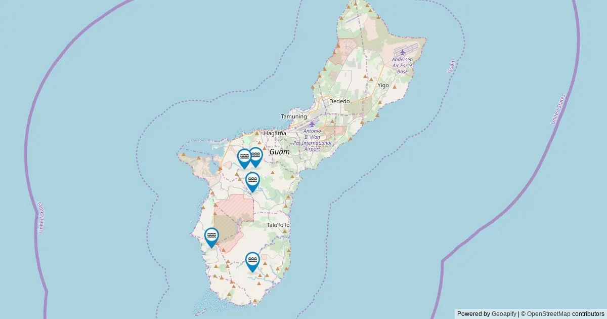
A comprehensive spatial inventory utilizing federal geographic records has cataloged seven officially named waterfalls across Guam. Derived from the United States Geological Survey’s (USGS) Geographic Names Information System (GNIS), the spatial dataset places the island territory at number 40 nationally in terms of officially recognized named falls within the federal database. While the total count represents a modest catalog compared to larger continental states, the dataset offers an authoritative look at the island’s recognized natural hydrographic features.
The interactive mapping project aggregates federal spatial data to provide exact geographic coordinates, administrative classifications, driving directions to the nearest accessible roadways, and direct deep-link references to underlying USGS archives. By indexing these features through standardized federal geographic parameters, the dataset bridges historical land-naming records and modern spatial analysis, offering researchers, land managers, and the public an organized overview of Guam’s cataloged waterfall network.
Mapping Federal Hydrographic Data in Guam
The integration of federal spatial data into accessible cartographic tools relies on public geographic databases maintained by the United States government. The USGS GNIS database serves as the authoritative repository for geographic names across all states, territories, and associated jurisdictions of the United States. Established to standardize geographic nomenclature, the database records natural and cultural features using precise geospatial metadata.
In mapping Guam’s named waterfalls, spatial queries extract features classified specifically under the "Falls" feature class within The National Map’s ArcGIS REST service. This system plots every official entry with precise latitude and longitude markers, allowing users to examine the spatial distribution of these water features across the island terrain.
Selecting individual data markers reveals key information, including administrative county classifications, exact coordinates, and routing information designed to guide users toward the closest established public thoroughfare. Furthermore, each entry links directly back to its corresponding record within the official GNIS archive, preserving the historical provenance of each named landmark.
Waterfalls in Guam by the Numbers
Quantifying natural features across federal datasets requires understanding the distinction between official geographical nomenclature and physical terrain features. According to the USGS GNIS inventory, Guam contains seven named waterfalls. This tally places Guam at the 40th position in national rankings when evaluated against all cataloged states and territorial jurisdictions in the federal system.
However, federal cataloging standards distinguish between named geographic features and unnamed physical phenomena. While seven waterfalls hold formal naming status within the federal system, the physical landscape of Guam contains additional seasonal cascades, ephemeral runoffs, and unnamed drops that appear following localized weather events. The official count of seven reflects only those features that have met the federal criteria for established geographic naming, having been documented through historical maps, local usage, or official government designation over the decades.
Geographical Distribution Across Guam
From an administrative and geospatial standpoint, federal data categorizes geographic features by county or county-equivalent divisions. In the case of Guam, the entire territory is classified within a single primary administrative jurisdiction for federal cataloging purposes. Consequently, Guam County encompasses all seven of the island’s named waterfalls documented in the federal archive.
Because the administrative framework for Guam does not subdivide the territory into traditional county units as seen in continental states, the dataset reflects a concentrated distribution where 100 percent of the cataloged named falls reside within the primary jurisdiction of Guam. This administrative baseline standardizes spatial querying, allowing federal agencies, researchers, and cartographers to compare Guam’s hydrographic features directly against county-level data across the broader United States national map network.
Distinctive Features of Guam’s Cataloged Waterfalls
The named waterfalls within Guam’s official catalog represent distinct geographical landmarks that have earned permanent entries in the national gazetteer. While physical characteristics such as vertical drop height, width, and volume vary across each site, their inclusion in the GNIS repository ensures that their official names and spatial locations are permanently preserved for cartographic and navigational purposes.
The federal dataset focuses specifically on cartographic location and nomenclature rather than structural dimensions. Consequently, the seven named falls mapped in Guam stand out not necessarily for being the largest or most voluminous, but for their established historical and geographical recognition. The complete dataset captured by the USGS incorporates every single one of these seven cataloged features, providing a definitive record of the island’s officially recognized falls.
Frequently Asked Questions Regarding Guam’s Waterfall Network
To provide clarity on how federal datasets record natural features and how members of the public can interact with these geographical records, several key technical and operational questions warrant detailed examination.
Official Tally and Hydrographic Realities
A common inquiry regarding island hydrology concerns the exact count of waterfalls present within the territory. The USGS GNIS records explicitly catalog seven named waterfalls within Guam. However, environmental experts and cartographers emphasize that the actual physical count of water cascades is higher when taking into account unnamed seasonal flows and minor drops.
The figure of seven represents the official federal benchmark, cataloging only those water features that possess an established, federally recognized name. Unnamed seasonal cascades that emerge temporarily during severe weather or heavy precipitation remain outside this named federal inventory unless formally submitted and approved by federal geographic naming authorities.
Jurisdictional Distribution
When analyzing the distribution of waterfalls by regional subdivisions, Guam County is listed as leading the territory with all seven named falls, with no other secondary county divisions present in the federal registry. This administrative structure means that regional comparisons within the island territory are consolidated under one primary reporting unit, streamlining local land management data and federal spatial reporting under a unified jurisdictional code.
Land Access, Management, and Visitor Guidelines
Accessibility to Guam’s named waterfalls varies depending on land ownership and management designations. A significant portion of cataloged falls across U.S. jurisdictions sits on publicly accessible lands, including state or territorial parks, National Forest systems, Bureau of Land Management tracts, or municipal properties. However, certain waterfalls may reside on private property or within specific tribal lands, each subject to distinct access regulations and private property rights.
Visitors and researchers seeking to locate these features must exercise due diligence by verifying land management status prior to visiting. Adherence to public access boundaries is mandatory, and trespassing on private lands without explicit authorization is strictly prohibited. While interactive mapping tools provide driving directions to the nearest public road or access point, reaching the actual waterfall site often requires navigating terrain via short or moderate foot hikes. Outdoor enthusiasts are advised to prepare for varying trail conditions and to respect all posted jurisdictional rules.
Seasonal Hydrology and Environmental Conditions
The hydrological behavior of Guam’s waterfalls fluctuates significantly based on seasonal weather patterns and atmospheric events. Peak flow conditions typically align with periods of heavy rainfall and seasonal precipitation cycles, which replenish surface water systems and dramatically increase water volume. Conversely, late summer and early autumn months often present lower water flow rates, though these periods frequently offer
clearer water conditions and distinct seasonal visual backdrop changes.
In contrast to high-elevation continental regions where waterfalls may freeze into dramatic ice formations during winter months, tropical oceanic environments like Guam experience hydrographic shifts driven primarily by wet and dry tropical seasons. Understanding these environmental dynamics is essential for predicting flow rates, water clarity, and overall safety conditions when surveying these natural landmarks.
Federal Data Collection and Archival Sources
The foundational dataset behind this comprehensive mapping project originates directly from the USGS Geographic Names Information System. Established in 1890, the GNIS serves as the official federal standard for U.S. place names, maintaining authoritative records for natural, cultural, and historic features across the country.
The specific data supporting the current Guam waterfall inventory was retrieved via a spatial query of The National Map’s ArcGIS REST service conducted in May 2026. This query filtered for all geographic features classified under the feature class of Falls within the geographical boundaries of Guam.
It is important to note that while the GNIS repository maintains precise coordinates, names, and administrative attributes, it does not record physical dimensions such as waterfall height or volume. For structural dimensions and volumetric metrics, specialized databases such as the World Waterfall Database serve as complementary analytical resources.
Navigating Guam’s Geographic and Spatial Resources
The integration of federal spatial data into interactive digital platforms highlights the growing importance of geographic information systems in public land documentation and resource management. By synthesizing complex spatial data into accessible cartographic interfaces, these digital resources allow researchers, policymakers, and outdoor enthusiasts to gain a clearer understanding of Guam’s physical geography.
As federal agencies continue to update spatial frameworks through projects like The National Map, the digital record of Guam’s natural landmarks remains preserved, accurate, and accessible. The mapping of Guam’s seven officially named waterfalls represents one component of a broader spatial effort to catalog, preserve, and understand the unique geographic heritage of the island territory within the national framework.