In mid-September 2026, a routine weather disturbance began taking shape off the Pacific coast of Mexico. What started as a modest cluster of thunderstorms quickly evolved into a meteorological phenomenon that left forecasters scrambling for superlatives. By September 20, the system had organized sufficiently to be designated as a tropical depression, and within just 24 hours, it strengthened into a tropical storm.
From that point forward, Hurricane Polo embarked on an extraordinary trajectory of rapid intensification that caught the meteorological community entirely off guard. Scientists and storm trackers struggled to find adequate adjectives to convey the sheer velocity of the storm’s transformation. Observers across social media and meteorological platforms described the rate of strengthening and overall intensity as jaw-dropping, astonishing, and even absolute insanity.
"Polo went through a period of what can only be described as explosively rapid intensification," said Gary Partyka, an atmospheric scientist with the Global Modeling and Assimilation Office at NASA’s Goddard Space Flight Center, in an email statement. "This was RAPID, rapid intensification."
According to Partyka, the storm found itself in an atmospheric environment that was nearly ideal for sustained strengthening. The regional conditions featured weak wind shear, abundant moisture, unusually high ocean temperatures, and elevated levels of atmospheric instability.
Several analysts and researchers turned to the formal classification of extreme rapid intensification to describe the event. This technical threshold is met when a tropical cyclone’s maximum sustained wind speeds increase by at least 60 knots—equivalent to 111 kilometers or 69 miles per hour—within a strict 24-hour window. Polo shattered this benchmark by an extraordinary margin. By September 22, the storm’s maximum sustained winds had surged by 90 knots, or 167 kilometers per hour, within a single day, violently thrusting the system into Category 5 status. In its normally restrained and staid forecast discussions, the National Hurricane Center labeled the rapid evolution as truly remarkable.
The reality of the storm’s ferocious power was confirmed when a NOAA Hurricane Hunter aircraft flew directly into the system on September 22. On-board researchers estimated flight-level winds of nearly 285 kilometers, or 180 miles, per hour. Based on these readings, some meteorological analysts noted that Polo secured its place as the third-strongest storm on record in the eastern Pacific by maximum sustained winds, while also setting a record as the fastest system to escalate from a tropical depression directly into a Category 5 hurricane.
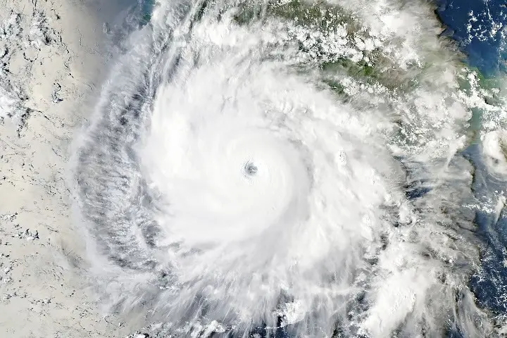
By the afternoon of September 23, the Moderate Resolution Imaging Spectroradiometer instrument, commonly known as MODIS, aboard NASA’s Aqua satellite captured high-resolution imagery of the massive hurricane churning off the coast of Guerrero, southwest of Acapulco. At the exact time the satellite image was acquired, Polo possessed maximum sustained winds of 230 kilometers, or 145 miles, per hour, positioning it as a powerful Category 4 storm. The slight dip in intensity was attributed to an eyewall replacement cycle, a natural internal process where a new eye forms around the old one, temporarily weakening the outer structure before it reorganizes.
"The satellite imagery of Polo is very impressive, with the storm’s large, clear eye and extensive outflow pattern," noted Kristen Corbosiero, an atmospheric scientist at the State University of New York at Albany, who is collaborating on a NASA project examining tropical cyclone ventilation using satellite observations. "Weak winds above the system and good outflow at the top of the system also contributed to Polo’s rapid intensification."
As Polo developed and marched northwestward, it tracked across ocean waters where sea surface temperatures reached a blistering 32 degrees Celsius, or 90 degrees Fahrenheit. These readings were a full 2 to 3 degrees warmer than typical historical averages for late September. Across vast stretches of the eastern Pacific, surface temperatures remained well above 27.8 degrees Celsius, or 82 degrees Fahrenheit, which is generally considered the critical threshold required to sustain and fuel major hurricanes.
Visual data from the Multiscale Ultrahigh Resolution Sea Surface Temperature project, managed by NASA’s Jet Propulsion Laboratory, provided a clearer picture of these thermal conditions. The project integrates satellite measurements from NASA, NOAA, and various international space agencies with direct ocean observations gathered from ships and drifting buoys. Rather than focusing solely on absolute water temperatures, researchers mapped thermal anomalies to illustrate precisely how much warmer or cooler the ocean surface was on September 23, 2026, compared to baseline averages recorded between 2003 and 2014.
While surface temperatures provided immediate fuel for Polo, Corbosiero emphasized that thermal energy stored deep beneath the surface likely played a critical role in maintaining the hurricane’s structural integrity. Powerful tropical cyclones frequently churn up cooler water from the ocean depths, creating a cold wake that can choke off a storm’s energy supply and halt intensification. In Polo’s case, however, satellite measurements and ocean models revealed that the cold wake left in the storm’s path was remarkably minimal, pointing to exceptionally high ocean heat content extending deep into the water column.
Despite the intense warmth of the Pacific, both Partyka and Corbosiero urged caution against attributing Polo’s explosive growth directly to El Niño, which has driven unusually high surface temperatures across the central and eastern Pacific Ocean. Corbosiero pointed out that several historical hurricanes in the region have undergone extreme rapid intensification during neutral conditions or even La Niña cycles, most notably Category 5 storms like Hurricane Otis in 2023 and Hurricane Patricia in 2015.
Nevertheless, overall tropical cyclone activity in the eastern Pacific typically increases during El Niño years due to broader shifts in global ocean and atmospheric circulation patterns. That larger trend has manifested clearly throughout the 2026 season. Data compiled by Colorado State University indicated that by September 24, the accumulated cyclone energy in the eastern Pacific was running at nearly twice the historical norm.
Forecasters and researchers monitoring the evolution of sea surface anomalies and subsequent storm tracks continue to utilize specialized tools such as NASA’s Worldview browser, near real-time data viewers provided by the Short-term Prediction Research and Transition project, and the GMAO FLUID tool. Current meteorological projections indicate that Hurricane Polo will remain over open Pacific waters before potentially curving toward the northeast and approaching the Baja California peninsula.