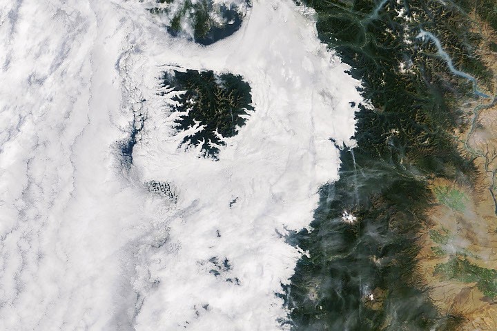
A sweeping low-lying cloud layer swept across western Washington and Oregon in mid-September 2026, delivering a quintessential autumn ambience to the Pacific Northwest. While valleys, coastal lowlands, and interior plains remained hidden beneath a uniform blanket of white, towering mountainous regions near the coast stood majestically above the pall, creating the striking illusion of rocky islands rising out of an endless sea of clouds.
The meteorological phenomenon, driven by cool marine air rolling off the Pacific Ocean, was documented in remarkable detail by Earth-observing satellites operated by NASA. As the region transitioned deeper into the autumn season, these atmospheric dynamics highlighted the complex interplay between maritime air masses, coastal topography, and regional weather patterns across the Pacific Northwest.
The Mechanics of Marine Stratus and Temperature Inversions
According to reports from the National Weather Service, a consistent pattern of onshore marine air flow persisted for several consecutive nights in mid-September 2026. This steady migration of atmospheric moisture brought widespread low-level clouds, scientifically classified as marine stratus, deep into the interior terrain.
Marine stratus decks characteristically form when moist air near the Earth’s surface becomes trapped beneath a warmer layer of air aloft, a meteorological condition known as a temperature inversion. As the trapped moisture cools sufficiently, water vapor condenses into microscopic droplets, forming a dense and expansive layer of stratus clouds.
This particular surge of cool, moist maritime air was notably robust during the early morning hours of September 19, 2026. The resulting cloud cover pushed far inland, extending all the way to the western foothills of the Cascade Range. In numerous lower-elevation valleys and localized pockets throughout western Washington and Oregon, the cloud deck settled directly onto the surface terrain, producing dense fog conditions that significantly reduced visibility for morning commuters and residents.
Satellite Perspectives from Space
The expansive reach of the regional cloud cover was captured on September 19, 2026, at approximately 10:45 a.m. Pacific Time (17:45 Universal Time) by the Moderate Resolution Imaging Spectroradiometer (MODIS) aboard NASA’s Terra satellite. The resulting satellite imagery revealed a thick, uninterrupted cloudy cloak stretching from far offshore across the Pacific Ocean, blanketing the entirety of western Washington and Oregon before terminating abruptly against the steep western slopes of the Cascades.
In addition to the pervasive marine layer, the Terra satellite imagery captured other distinct environmental features shaping the Pacific Northwest landscape on that mid-September day. Abundant cloud formations lingered far out over the open waters of the Pacific Ocean, while plumes of smoke from active wildland fires were visible drifting through and filling valleys tucked within the North Cascades.
The persistence of the marine layer, however, proved transient in many locations as solar heating took effect later in the day. When NASA’s Aqua satellite made a subsequent orbital pass over the region at approximately 4:15 p.m. Pacific Time (23:15 Universal Time) on September 19, daytime heating had successfully eroded the cloud deck across a significant portion of the interior lowlands, leaving clear skies overhead for much of Washington and inland Oregon.
Despite the afternoon clearing inland, remnants of the stubborn marine layer continued to cling tightly to sections of the Oregon coastline. Protected by the cooler maritime influence, coastal areas experienced lower afternoon temperatures compared to locations further inland, where sunshine was able to warm the surface undisturbed.

The high-resolution imagery utilized by researchers to analyze these dynamic meteorological events was processed by the NASA Earth Observatory, relying on MODIS data provided by NASA’s Earth Observing System Data and Information System (EOSDIS) Land, Atmosphere Near real-time Capability for EOS (LANCE) and the GIBS/Worldview mapping platforms.