The compounding effects of a severe winter snow drought and persistently high temperatures across the Upper Colorado Basin have pushed America’s water storage systems to unprecedented lows. By late summer 2026, Lake Powell—the second-largest reservoir in the United States—dropped to record-low water levels, laying bare the deepening strains of a 21st-century megadrought that continues to challenge resource managers across the American West.
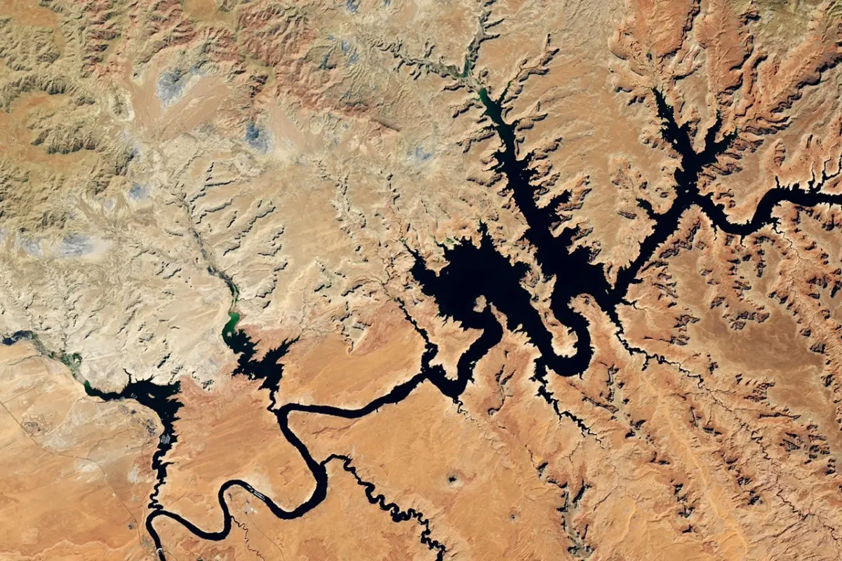
Satellite observations captured by the Operational Land Imager (OLI) on the NASA-USGS Landsat 8 satellite illustrate the dramatic retreat of water near Glen Canyon Dam. Comparing images from September 1, 2017—a period representing some of the highest water levels of the past decade—to September 10, 2026, reveals a stark transformation of the landscape.
By September 10, 2026, the water level at Lake Powell had fallen to 3,517.24 feet. This milestone came roughly a month after the reservoir dipped below its previous historic low of 3,519.92 feet, a mark set on April 13, 2023. Throughout late August and early September 2026, the water levels continued their downward trajectory, exacerbating concerns for millions of residents, agricultural producers, and ecosystems dependent on the Colorado River system.
The Anatomy of a Snow Drought
The crisis unfolding at Lake Powell has its roots in the winter weather patterns of 2025 through 2026. Much of the Colorado River Basin is defined by an arid or semi-arid climate, making the region heavily reliant on seasonal snowpack. A vast proportion of the river’s annual flow originates as snowmelt from higher-elevation mountainous regions during the spring and summer months.
However, the Upper Colorado Basin, much like numerous other mountainous areas across the U.S. West, experienced an acute deficiency in winter snow accumulation. This phenomenon, known scientifically as a snow drought, was compounded by stretches of unseasonably warm temperatures throughout the winter and spring. Instead of accumulating a robust snowpack that would gradually melt and replenish downstream reservoirs during the warmer months, the region saw meager winter precipitation and premature melting. The seasonal snowmelt was reduced to a relative trickle, failing to provide the vital spring surge that lake levels traditionally depend upon to weather the dry summer months.
Downstream Impacts and Regional Vulnerabilities
The Colorado River serves as an indispensable lifeline for the American Southwest, feeding Lake Powell before flowing onward to Lake Mead, the nation’s largest reservoir. Lake Mead also hit record-low levels in August 2026, mirroring the crisis upstream and compounding pressures on the entire river network.
Managed cooperatively by the U.S. Bureau of Reclamation (USBR) and various state and federal agencies, the Colorado River system supplies municipal water and hydroelectric power to more than 40 million people. Major metropolitan areas, including Las Vegas, Phoenix, Los Angeles, and San Diego, rely heavily on this infrastructure. Additionally, the river provides irrigation water for approximately 5 million acres of highly productive farmland across the Southwest.
With both major reservoirs plumbing historic depths, the operational stability of the entire basin has been pushed to the edge. The vulnerabilities exposed by the 2026 snow drought underscore the delicate balance required to manage an over-allocated river system facing the long-term pressures of regional aridification and climate variability.
Emergency Intervention and Environmental Trade-offs
Recognizing the escalating peril, the U.S. Bureau of Reclamation took decisive action in April 2026 to stabilize Lake Powell. Without intervention, federal projections indicated that the reservoir’s water levels could have dropped below the critical threshold required for hydropower production by August 2026—an outcome that would have disrupted electricity generation for vast portions of the region.
To avert this scenario, the USBR initiated emergency water releases from Flaming Gorge Reservoir, located upstream in northern Utah and southern Wyoming, directing the water southward into Lake Powell. Simultaneously, the agency reduced water releases from Lake Powell into Lake Mead, attempting to preserve a precarious equilibrium between the two storage giants.
These emergency measures, however, required significant environmental trade-offs. To conserve water in the system, the USBR canceled a scheduled "controlled flood" in April 2026, which was originally intended to build sandbars and restore natural fish habitats along the river. Furthermore, the agency skipped a "cool mix" release planned for August, an operational maneuver typically deployed to protect native aquatic species by regulating downstream water temperatures. These cancellations highlighted the difficult choices resource managers face as they balance human water and power demands against the health of river ecosystems.
High-Tech Monitoring and Advanced Decision-Making Tools
The U.S. Southwest has been gripped by sustained drought conditions since the beginning of the 21st century, a prolonged period that experts characterize as a megadrought. As this extended dry spell continues to strain regional water availability, scientists and resource managers are increasingly turning to advanced technology and Earth observations to track conditions and guide policy responses.
NASA-funded projects and tools powered by satellite data are playing an instrumental role in helping decision-makers monitor the basin and respond to shifting environmental pressures. At the headwaters of the Colorado River, a specialized dashboard utilizing the Western Land Data Assimilation System provides real-time visualizations of soil moisture, snow water equivalent, and evapotranspiration. These metrics directly inform Colorado’s drought task force and contribute vital data to the weekly U.S. Drought Monitor maps.
Closer to Lake Powell, the Drought Severity Evaluation Tool—co-developed with the Navajo Nation—enables tribal leaders to monitor localized drought indices, precipitation trends, and vegetation health across indigenous lands. Originally established for regional tribal resource management, the tool’s adoption expanded in 2025 to include Oklahoma’s Chickasaw and Choctaw Nations, with funding support from the National Integrated Drought Information System administered by NOAA.
Additionally, researchers at Arizona State University, in partnership with the Central Arizona Project, developed the Colorado River Integrated Assessment tool. This comprehensive platform consolidates improved hydrological modeling with satellite-validated information regarding snowpack, surface water, groundwater storage, and soil moisture across the entire basin into a single interactive interface. By synthesizing these diverse streams of data, water administrators and policymakers are better equipped to navigate the complex challenges posed by an increasingly variable climate and diminishing water reserves in the American West.