The naturally occurring climate phenomenon known as El Niño has officially entered record-breaking territory, with tropical Pacific sea surface temperatures surpassing the previous daily peak set during the historic 2015 event.
El Niño, a periodic climate driver originating in the Pacific Ocean, fundamentally reshapes weather patterns across the globe while temporarily driving up global average temperatures. The current event, which first took shape in June and is projected to persist well into next year, has developed at a pace faster than any previously recorded episode in modern meteorological history.
Scientists track the intensity of these events using the Niño 3.4 anomaly index, a metric that measures how much warmer sea surface temperatures are compared to average in a designated region of the central Pacific. As of September 21, the daily anomaly within the Niño 3.4 region reached 3.11 degrees Celsius, edging past the previous daily high of 3.08 degrees Celsius, which was established on November 18, 2015.

While some researchers utilizing alternative calculation baselines noted the record a few days earlier, the milestone remains remarkable primarily due to how early in the calendar year it is occurring. El Niño events typically experience their most intense phases during the Northern Hemisphere winter months, most commonly peaking in November or December. Historically, every strong El Niño on record has continued to intensify past mid-September, leaving climatologists with every reason to anticipate further growth in the months ahead.
Record Territory and Baseline Comparisons
Within the framework of climate science, El Niño episodes are generally categorized by the magnitude of their Niño 3.4 anomalies. A reading of 0.5 degrees Celsius is typically classified as weak, values above 1 degree Celsius are considered moderate, thresholds exceeding 1.5 degrees Celsius denote a strong event, and readings above 2 degrees Celsius are categorized as very strong.
With the current anomaly standing at 3.11 degrees Celsius, the 2026 event has surpassed the peak daily thresholds of previous mega-events, outpacing both the 2015-2016 cycle and the severe 1997-1998 El Niño.
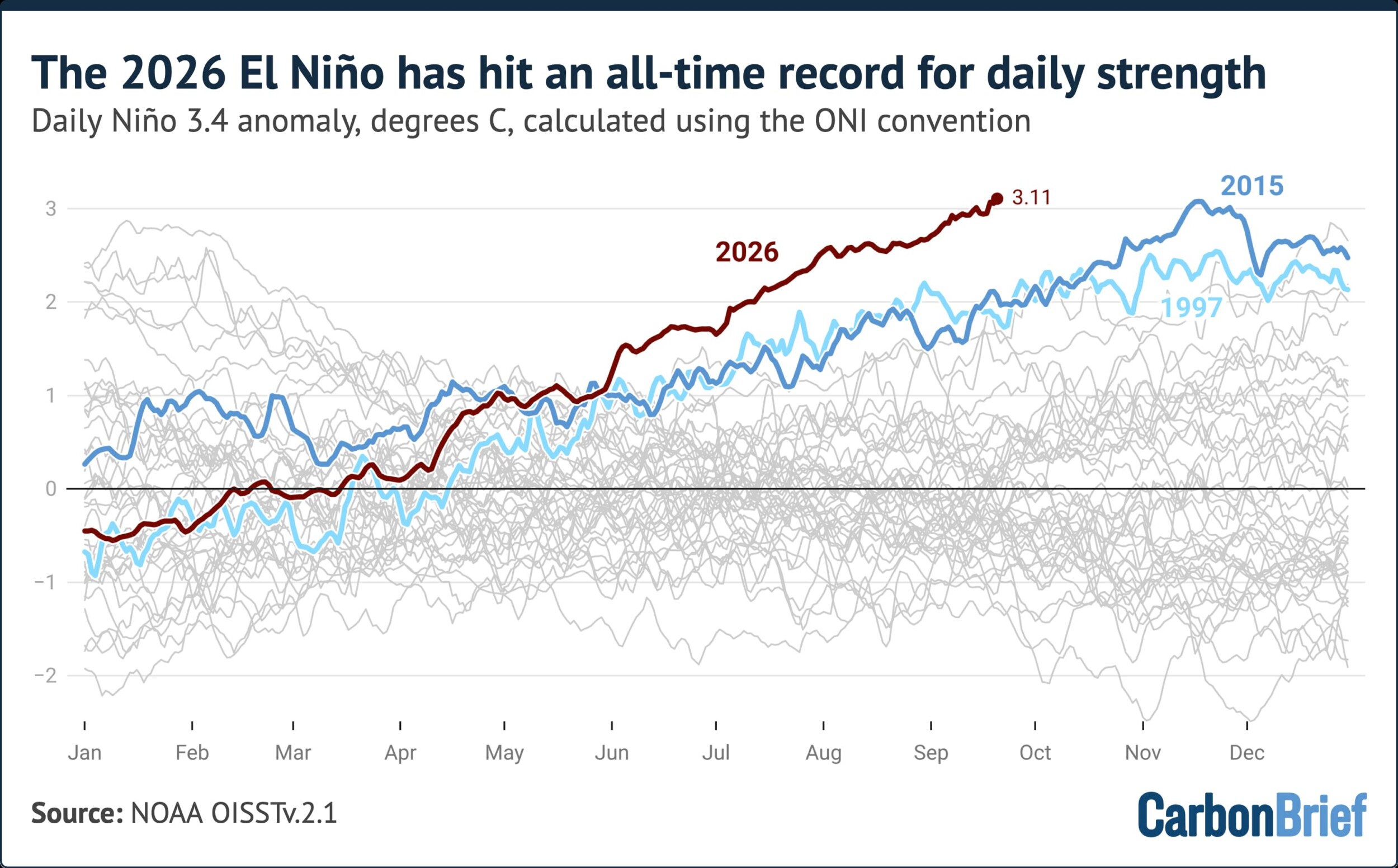
To analyze the trajectory of the developing phenomenon, researchers frequently adhere to the conventions established by the United States National Oceanic and Atmospheric Administration (NOAA) through its Oceanic Niño Index, commonly known as ONI. The ONI is derived by subtracting the most recent 30-year average temperature in the Niño 3.4 region from daily sea surface temperatures. This analytical approach allows contemporary conditions to be evaluated against the most recent three-decade baseline, effectively stripping away much of the underlying influence of long-term, human-induced global warming.
While meteorological institutions typically monitor ONI shifts on a three-month rolling average basis, granular daily analyses reveal the unprecedented nature of the current setup. When calculated using a 1991-2020 climatological baseline, the current El Niño has already shattered historical benchmarks. Since the onset of June, the intensity of the event has outstripped all comparable historical periods. By early September in both 1997 and 2015, respective anomalies hovered around 1.9 degrees Celsius—roughly one full degree below current observations.
An Alternative Index
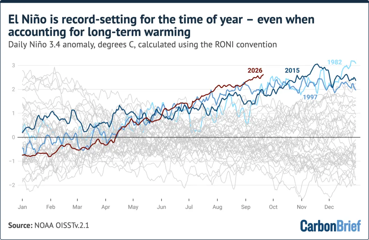
To gain a more comprehensive perspective, researchers also utilize an alternative metric known as the relative Oceanic Niño Index, or RONI. Introduced by NOAA in 2024, the RONI framework is specifically designed to adjust for broad tropical ocean warming directly linked to human-caused climate change.
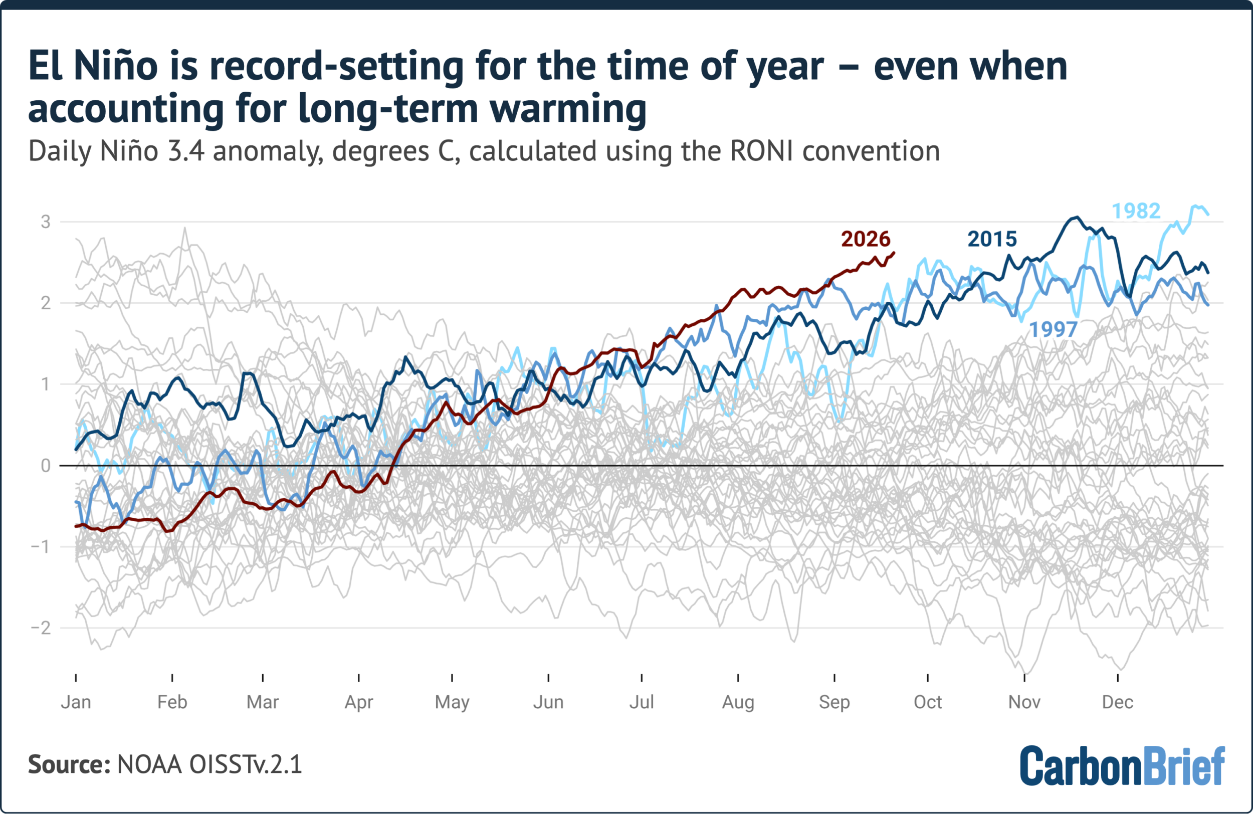
The RONI methodology calculates sea surface averages in the Niño 3.4 region and subtracts the broader temperature anomalies observed across the entire tropical ocean expanse, spanning latitudes between 20 degrees north and 20 degrees south. While this adjustment successfully isolates regional dynamics from background planetary warming, it can occasionally diminish the apparent statistical strength of exceptionally potent El Niño events whose atmospheric and oceanic footprints extend well beyond the traditional Niño 3.4 boundaries.
Recent daily RONI figures illustrate this complexity. While these relative anomalies are setting records for this specific time of year, they still remain below the all-time daily record established during the severe 1982-1983 El Niño event. In mid-September, the RONI metric stood at approximately 2.5 degrees Celsius, sitting about 0.7 degrees Celsius below the peak record set in late 1982.
However, climatologists emphasize that the 1982 benchmark was reached at the absolute climax of that winter event. Historical data from the 1982-1983, 1997-1998, and 2015-2016 cycles show that these events typically added between 0.5 and 1.9 degrees Celsius to their RONI values between mid-September and their ultimate seasonal peaks.
On Track to Smash Monthly and Seasonal Records
Because daily El Niño measurements exhibit significant natural variability and "noise," scientists frequently rely on monthly or seasonal averages to draw accurate historical comparisons between different events.
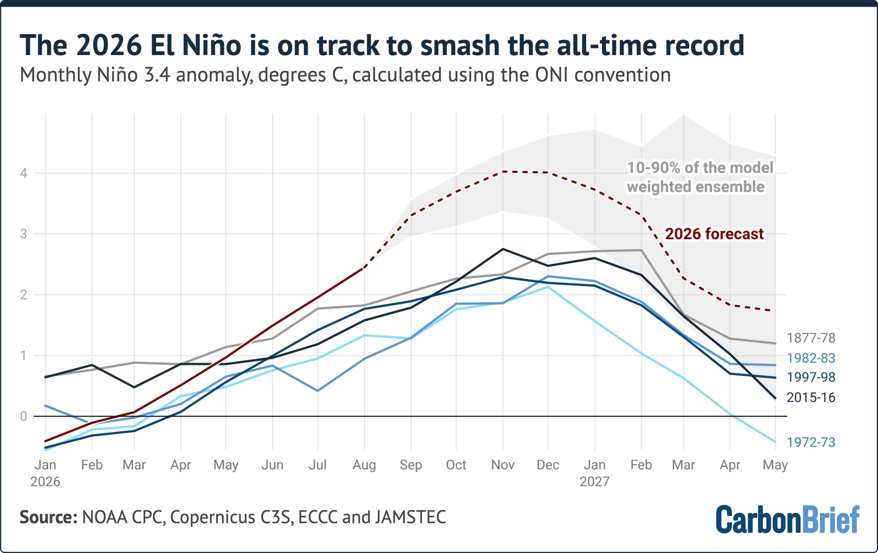
Data for August 2026 revealed a Niño 3.4 monthly anomaly of approximately 2.45 degrees Celsius. This single-month average surpasses the absolute peak of nearly every prior recorded El Niño event in history, with only two exceptions: the 2015-2016 event, which reached a monthly anomaly of 2.75 degrees Celsius, and the severe 1877-1878 event, estimated at roughly 2.7 degrees Celsius based on sparse historical ship logs and climate reconstructions.
Projections synthesized from 14 international seasonal forecast models suggest that the monthly anomaly will continue its ascent, peaking later in the year at approximately 4.1 degrees Celsius. Roughly 80 percent of the 674 individual model runs cluster between 3.4 and 4.6 degrees Celsius.

Crucially, every single model run projects a peak exceeding the previous record set in 2015-2016. The projected margin over that historical high—roughly 1.3 degrees Celsius—is larger than the entire gap separating the strongest and fifth-strongest El Niño events observed over the past century and a half.
Despite the near-unanimous consensus among forecasting models, scientists maintain a degree of caution. No existing seasonal forecast system has ever been tested against an event of this magnitude because an episode of this scale has never been instrumentally recorded. Furthermore, models exhibited a slight warm bias during the summer months, with real-world observations for August coming in about 0.3 degrees Celsius below preliminary forecasts.
Nevertheless, the historical precedent remains clear: all strong El Niño events on record have continued to strengthen deep into the winter months, and current modeling aligns in predicting the same trajectory for the ongoing cycle. Should these projections materialize, the event will peak between November and January at an intensity far exceeding any recorded precedent.
Because the atmospheric and global temperature impacts of an El Niño typically lag behind peak ocean surface temperatures by several months, the most profound global consequences will likely manifest in 2027 rather than 2026. Recent quarterly climate assessments indicate that 2026 is already firmly on track to secure its place as one of the warmest years in modern records, while ongoing scientific analyses continue to evaluate how this unprecedented Pacific warming will influence global weather patterns and temperatures in the year ahead.