Skip to content
Breaking News
  • GeoHound Tool Launches as Chrome Extension to Instantly Detect, Analyze, and Process Web Map Data
  • From ERP Systems to AI Strategy: Inside Aakansha Bhalotia’s 13-Year Tech Journey at Precisely
  • Elistair Unveils Tethered Air Module for the Parrot ANAFI UKR to Enable Extended ISR Missions
Thursday, October 22, 2026
Edition: U.S. International Login

Hack The Map

Author: Muslim

Open Source Geospatial Software

GeoServer 3.0.2 Released with Major Security Updates, OGC API Maps 1.0, and GeoFence Integration

October 21, 2026 Muslim
The open-source geospatial community has announced the official release of GeoServer 3.0.2, a stable version recommended for immediate production deployments.…

Location Intelligence and Spatial Analytics

Precisely Launches Unified Data Platform and AI Studio to Help Enterprises Prepare for Autonomous Systems

October 19, 2026 Muslim
Data integrity leader Precisely has officially entered a new chapter in its corporate history, introducing a comprehensive suite of solutions…
Open Source Geospatial Software

GeoServer Issues Urgent Security Update After August Zero-Day Exploitation and Summer Vulnerability Review

October 18, 2026 Muslim
The GeoServer project has issued a comprehensive security recap detailing a turbulent summer of 2026, which included managing a critical…
Location Intelligence and Spatial Analytics

Precisely Unveils Unified Platform, AI Studio, and MCP Servers to Help Enterprises Build AI-Ready Data

October 18, 2026 Muslim
The landscape of enterprise technology is shifting beneath the feet of Chief Data Officers and IT leaders worldwide. On October…
Environmental and Climate Mapping

More Than Half of UN Countries Submit Nature Pledges Ahead of COP17 Summit

October 17, 2026 Muslim
Nearly three years after a landmark global agreement was struck to halt and reverse the destruction of the natural world,…
Environmental and Climate Mapping

More Than Half of Global Nations Meet UN Deadline to Submit Nature Pledges Ahead of COP17

October 17, 2026 Muslim
More than half of the world’s countries have now met a United Nations call to submit new national pledges aimed…
Data Visualization and Infographics

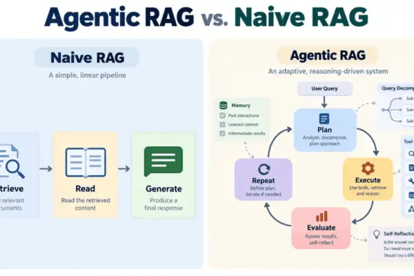
Beyond the Single Search: How Agentic RAG is Reshaping Enterprise AI Architecture

October 16, 2026 Muslim
Large language models have fundamentally transformed how organizations interact with data, serving as remarkable text generators capable of drafting code,…
Environmental and Climate Mapping

Global Financing for Nature Falls Dangerously Short of UN 2030 Targets, Stocktake Report Warns

October 16, 2026 Muslim
The financial resources directed toward protecting global biodiversity fall drastically short of what is required to meet the United Nations’…
Environmental and Climate Mapping

More Than Half of World’s Nations Meet UN Deadline for Nature Pledges Ahead of COP17

October 16, 2026 Muslim
Nearly three years after the international community struck a landmark pact to halt and reverse the destruction of the natural…
Transportation and Mobility Tech

Comprehensive Industry Review Highlights Top-Rated Wheelchairs for Enhanced Mobility and Independence

October 16, 2026 Muslim
Wheelchairs remain among the most widely utilized medical devices worldwide, serving as an essential lifeline for individuals managing mobility impairments.…

Posts navigation

Older posts

Recent Posts

  • GeoHound Tool Launches as Chrome Extension to Instantly Detect, Analyze, and Process Web Map Data
  • From ERP Systems to AI Strategy: Inside Aakansha Bhalotia’s 13-Year Tech Journey at Precisely
  • Elistair Unveils Tethered Air Module for the Parrot ANAFI UKR to Enable Extended ISR Missions
  • A 178-Year-Old Train Delay Solves a Major Mystery in the History of Space Weather and Solar Storms
  • Urban Parking Costs and Curb Management Drive Traffic and Transportation Planning Challenges, New Report Shows

Recent Comments

No comments to show.

Archives

  • October 2026
  • September 2026
  • August 2026

Categories

  • Data Visualization and Infographics
  • Disaster Response and Humanitarian Mapping
  • Drone Mapping and Aerial Photography
  • Environmental and Climate Mapping
  • Geography and Earth Science
  • Geolocation and Cybersecurity
  • Geopolitics and Map News
  • GIS and Spatial Technology
  • Location Intelligence and Spatial Analytics
  • Open Data and Civic Tech
  • Open Source Geospatial Software
  • OpenStreetMap and Community Mapping
  • Remote Sensing and Satellite Imagery
  • Transportation and Mobility Tech
  • Travel Hacking and Digital Nomad
  • Urban Planning and Smart Cities
  • Web Mapping and Cartography

© 2026 Hack The Map. All rights reserved.

Theme: The Original by Rifan Muazin.