Located in the Weddell Sea just east of the Antarctic Peninsula, Vega Island presents a striking and haunting visage when observed from high above. Its rugged topography of exposed rock and accumulated ice forms a shape that uncannily resembles a grinning skull seen in profile, seemingly staring across the frozen expanse toward nearby Devil Island. While this striking geomorphological coincidence has captured the imagination of scientists and space observers alike, a far more serious narrative lies behind the unusual sight—one concerning the shifting environmental conditions and accelerating transformation of Antarctica’s glaciers amid a warming global climate.
Recent satellite imagery released by NASA brings this glacial phenomenon into sharp focus, offering a side-by-side comparison that highlights the rapid seasonal and annual shifts taking place in the region.
NASA Satellite Images Reveal Antarctica’s Icy Skull
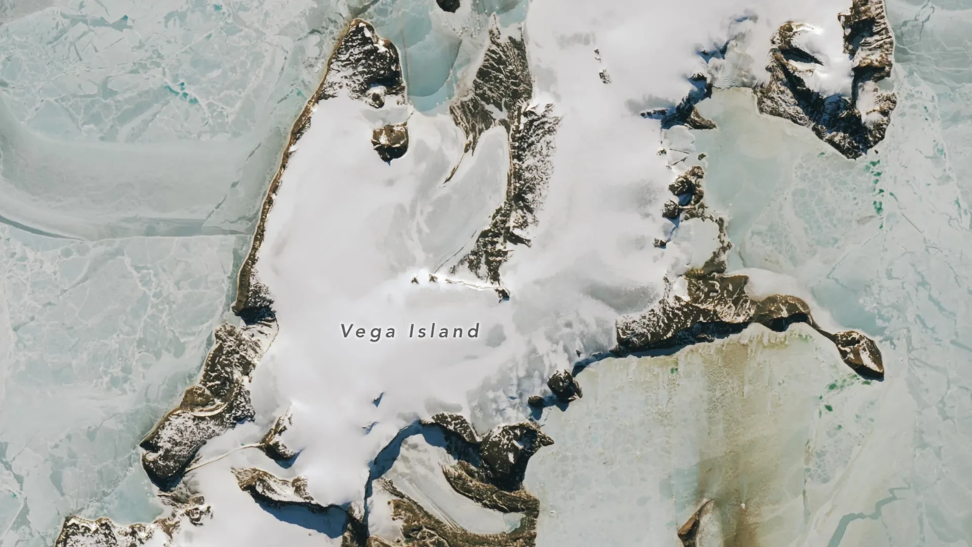
The visual evidence comes directly from spaceborne observation tools operated by the United States space agency. NASA satellite images show Vega Island during the onset of Antarctic autumn and during the spring thawing period. These vantage points were captured by the Operational Land Imager, commonly known as OLI, aboard the Landsat 9 satellite. The comparative frames were recorded on March 22, 2025, and October 10, 2026, respectively. While a planned observation in March 2026 was obscured by dense cloud cover, the available imagery provides a dramatic window into the island’s changing surface conditions.
A combination of distinct natural geological landmarks creates the skull’s eerie and unmistakable appearance from orbit. An isolated rocky peak, known scientifically as a nunatak, rises prominently above the surrounding glacial ice sheet to form what looks unmistakably like an empty eye socket. Below it, a lateral moraine—a natural ridge of debris and rocky material left behind along the side of a receding glacier—outlines the contours of a skeletal mouth. Completing the face, the Bahía del Diablo, or Devil’s Bay Glacier, carves out the sweeping shape of the skull’s lower jaw.
Comparing the two satellite frames reveals a dramatic and telling disparity in snow coverage across the terrain. In the March 2025 image, a heavy, pristine blanket of snow covers the icy landscape. This dense accumulation aligns with regional climate patterns that traditionally make March one of the wettest months of the year in this sector of the Antarctic Peninsula. However, by October 2026, the landscape had transformed dramatically. Extensive sections of the island were entirely stripped of snow, leaving dark, weathered glacier ice exposed to the elements over vast areas.
Mauri Pelto, a glaciologist with Nichols College, analyzed the data and pointed to anomalous regional weather patterns as the primary culprit. Unusually warm conditions throughout the winter of 2026—with particularly elevated temperatures recorded during the month of June—directly contributed to the unusually large zones of exposed ice documented by October. According to Pelto, the bare surfaces visible on Vega Island, alongside similar phenomena on neighboring islands, indicate that remarkably little fresh snow managed to accumulate over the course of the winter season. Furthermore, much of the snow that did fall was subsequently lost through sublimation, a physical process where ice transitions directly from a solid into water vapor without melting first, as well as through fierce, persistent winds that scoured the landscape clean.
Summarizing the severity of the off-season conditions, Pelto noted that the winter season was no treat for these fragile coastal glaciers.
Why Exposed Ice Could Accelerate Glacier Melting
The widespread absence of a protective snow cover carries profound implications as Antarctica transitions deeper into its warmer seasonal cycle. Fresh, white snow possesses a high albedo, meaning it reflects a significant majority of the incoming solar radiation back into space. Conversely, darker, exposed glacial ice absorbs a vastly higher proportion of solar energy. As daylight hours lengthen and ambient temperatures rise during the polar spring and summer, these darker patches absorb heat much more rapidly, a dynamic that threatens to significantly accelerate the rate of glacier melting.
While the situation is precarious, the destructive feedback loop could be temporarily mitigated if the region experiences even modest fresh snowfall. A thin layer of new snow would serve as a temporary shield, temporarily halting the direct absorption of solar radiation by the dark ice beneath.
Noting this narrow window of potential stabilization, Pelto emphasized that even a thin cover of new snow from a spring storm would be helpful in the short run.
This ongoing and potentially accelerating melting threatens to alter the island’s famous geomorphology. The very ice and rock configurations that currently give Vega Island its haunting skull shape are inherently vulnerable to physical erosion and structural collapse as the glaciers continue to retreat. When entombed safely beneath thick layers of snow and ice, the delicate glacial features of the skull are preserved against the elements. However, once exposed to active melting, the structure begins to weather away rapidly, a process that glaciologists warn will inevitably lead to a changing jawline and an expanding, distorted eye socket.
Decades of Glacier Loss on Vega Island
Scientific inquiry into the glacial health of Vega Island is not a recent development. Researchers have been actively studying the ice formations of the island for decades, with satellite observations serving as a critical tool for long-term monitoring and baseline documentation.
One of the earliest comprehensive and detailed surveys of the island’s ice cover appeared in a landmark 1982 scientific study. That research utilized early-generation Landsat satellite data, historical aerial photography, and detailed topographic maps to evaluate the extent of the ice. At the time, researchers identified four distinct ice caps on Vega Island, alongside jagged rocky cliffs protruding above the frozen surface and active glaciers flowing outward from the central ice caps. In total, the historic survey documented 29 individual glaciers distributed across the island.
Among these, the Devil’s Bay Glacier has received intensive scrutiny, having been monitored in meticulous detail since the Antarctic summer of 1998 and 1999. Field measurements and remote sensing data collected continuously over the intervening decades demonstrate an unmistakable, overall reduction in the glacier’s total mass.
These negative mass balances are not isolated to Devil’s Bay. Broader satellite observations spanning recent decades confirm that numerous other glaciers situated across Vega Island have experienced sustained ice loss, gradually uncovering larger and larger swaths of the underlying bedrock.
Vega Island’s Remarkable Antarctic Survival Story
Long before the advent of satellite constellations and space-based remote sensing, Vega Island occupied a central place in the human history of Antarctic exploration, playing an unexpected role in one of the continent’s most dramatic survival sagas.
During the Swedish Antarctic Expedition of 1901 through 1903, a team of scientists and sailors traveled to the region with the primary objective of investigating the geography, geology, climate, and biological life of the eastern Antarctic Peninsula and its surrounding archipelagos. What was planned as a systematic scientific mission soon devolved into a desperate battle against the elements.
As the expedition progressed, the explorers found themselves divided into three separate groups, each forced to hunker down and endure the brutal Antarctic winter in isolated locations. The peril escalated dramatically when heavy pack ice crushed and destroyed their expedition ship, leaving the entire crew stranded in one of the most hostile environments on Planet Earth.
Despite the immense hardships and psychological toll, Vega Island eventually became the backdrop for a historic moment of relief and human endurance. In the spring of 1903, two of the separated groups successfully reunited at a coastal spot later named Cape Well-met, located near the area that today resembles the forehead of the island’s prominent rock-and-ice skull.
Shortly after this morale-boosting reunion, an Argentine relief expedition arrived in the sector and safely evacuated the exhausted survivors, bringing their extraordinary Antarctic ordeal to a close.
Today, Vega Island remains a unique intersection where striking geological formations, a rich legacy of historic exploration, and the urgent realities of a changing global climate converge. While its ghostly, skull-like visage may endure as one of Antarctica’s most unusual and photogenic sights, the continuous transformation of the ice that shapes it tells a much deeper and more consequential story about the future of the polar environment.