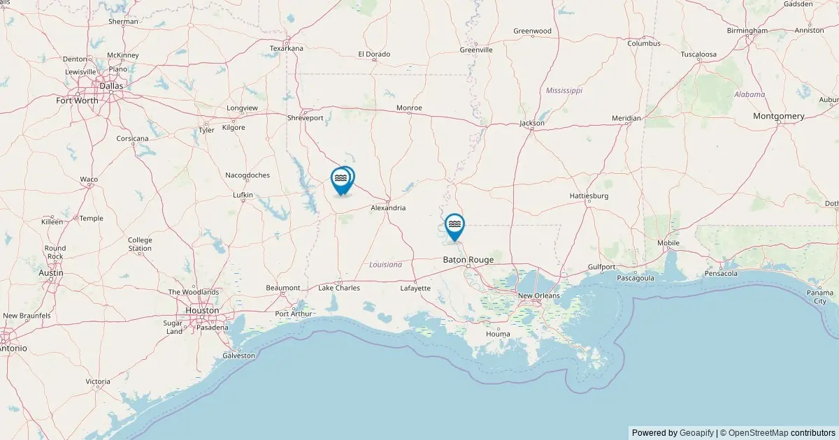
Comprehensive geographical data maintained by the federal government highlights a lesser-known dimension of the Louisiana landscape: its official named waterfalls. According to records from the United States Geological Survey’s Geographic Names Information System, Louisiana is home to three officially named waterfalls. This tally places Louisiana at 48th in the national rankings for total named falls, placing it near the bottom of national counts but preserving a small, highly distinct collection of hydrological features scattered across its terrain.
While the state is predominantly recognized for its vast coastal marshes, expansive river deltas, low-lying bayous, and floodplain basins, local geological variations create conditions where running water drops over exposed rock strata and sediment layers. The official federal mapping dataset, updated following a comprehensive query of The National Map’s ArcGIS REST service, isolates these specific locations, providing exact geographic coordinates, administrative boundaries, and direct links to federal historical records for each site.
The documentation of these landforms provides a clearer picture of how water moves across the state’s varied topographies, offering researchers, outdoor recreationists, and cartographers a complete look at Louisiana’s officially cataloged falling waters.
Geographical Distribution Across Louisiana Parishes
The spatial distribution of named waterfalls in Louisiana is narrowly concentrated within specific geographic regions where elevation shifts and erosion patterns allow for distinct aqueous drops. The federal dataset shows that only two civil divisions within the state contain officially recognized named waterfalls.
Natchitoches Parish leads the state in waterfall concentration, serving as the location for two of the three recognized falls. Located in the north-central region of Louisiana, Natchitoches Parish features rolling pine hills, sandstone bluffs, and dissected watersheds that break away from the flat alluvial plains of the Red River valley. The local geology of this area creates natural gradients where small tributaries cut through harder substrate layers, forming low-elevation drops and cascades cataloged within the federal database.
West Feliciana Parish contains the state’s third officially named waterfall. Situated in east-central Louisiana along the eastern banks of the Mississippi River, West Feliciana Parish is widely known for its dissected loess bluffs and deep ravine systems, often referred to as the Tunica Hills region. The steep topography of these ravines creates localized drops along upland creek beds, where seasonal and perennial streams carve paths down to the surrounding river basins.
Together, these two parishes encompass the entirely known list of federal waterfall designations within Louisiana borders. Outside of Natchitoches and West Feliciana, no other parish in the state contains a feature officially classified under the federal "Falls" designation.
Understanding the USGS GNIS Data and Methodology
The primary database for identifying and categorizing these natural features is the Geographic Names Information System, maintained by the United States Geological Survey. Established in 1890, the GNIS serves as the official federal standard for U.S. place names, geographic features, and administrative locations. The dataset provides a standardized repository of named geographical entities to maintain consistency across federal, state, and municipal mapping initiatives.
The data for Louisiana’s waterfalls was retrieved through a specialized spatial query of The National Map’s ArcGIS REST service, specifically isolating geographic features classified under the feature class of "Falls" within the state’s geographic boundaries.
It is important to note the distinction made by federal cartographers regarding what constitutes an official entry. The federal database records only features that carry an established, recognized proper name documented through official records, historical maps, or local civic usage. Consequently, while the true physical count of cascading water features across Louisiana is higher when including unnamed seasonal drop-offs, intermittent rapids, and temporary runoff channels, exactly three features possess the historical and administrative criteria required for an official federal name listing.
Additionally, the GNIS system focuses strictly on nomenclature, geographic location, county/parish placement, and administrative tracking. It does not measure physical characteristics such as vertical drop height, volume of discharge, or structural classification. For structural measurements and physical dimensions of these falls, researchers reliance shifts to specialized repositories such as the World Waterfall Database, which tracks physical metric details independently of federal naming registries.
Accessibility, Land Ownership, and Visitor Guidelines
Navigating to Louisiana’s named waterfalls requires an understanding of land tenure and jurisdictional oversight. The majority of named falls in the state are located on publicly accessible land managed by federal, state, or municipal agencies. These parcels include areas within state parks, tracts within Kisatchie National Forest, properties under the jurisdiction of the Bureau of Land Management, and various local parish or municipal reserves.
However, land boundaries in these rural and forested regions can be intricate. Certain water features or their immediate surrounding corridors rest on private property or tribal lands, which carry specific access restrictions and legal protections. Visitors planning to observe these natural sites are advised to confirm the underlying land ownership and consult the appropriate land management entity before visiting to ensure public access is permitted and to prevent trespassing.
Accessing the physical sites typically involves a multi-stage approach. The geographic coordinates provided within the federal database direct travelers to the nearest public roadway or established vehicle access point. From those locations, reaching the water feature itself often requires traversing foot trails or unpaved paths, ranging from brief walks to moderate hikes through native upland terrain and ravine systems.
Because these natural areas can be sensitive to foot traffic and environmental disruption, land managers emphasize sticking to designated trails, observing posted signage, and respecting both public conservation rules and surrounding private boundary lines.
Seasonal Hydrology and Peak Viewing Conditions
The flow rates and visual characteristics of Louisiana’s waterfalls fluctuate substantially throughout the year, driven primarily by regional precipitation patterns and climate dynamics. Unlike high-altitude mountain cascades fed by massive continuous snowpack, Louisiana’s falls rely on localized watershed drainage, seasonal rainfall, and immediate ground saturation.
Peak flow conditions across the state generally occur during the spring months. Heavy seasonal rainfall, combined with localized runoff, fills tributary systems and pushes water levels to their maximum volume. Secondary high-flow events occur following significant atmospheric rain systems and tropical weather events during the late summer and autumn months.
Conversely, late summer and early autumn often bring drier ambient conditions, resulting in lower water volume across small tributaries. While low-flow periods reduce the volume of cascading water, they frequently offer clearer stream conditions and enhanced visibility of the underlying geological structures, rock beds, and surrounding forest vegetation as autumn foliage changes.
In rare instances during severe winter weather events, low temperatures in elevated or sheltered valley microclimates can cause localized freezing along stream margins. In these brief windows, shaded drops and trickling cascades can form temporary ice structures over exposed rock ledges, presenting a sharp contrast to the state’s typical temperate hydrological patterns.
Answers to Key Questions Regarding Louisiana Waterfalls
How many waterfalls are there in Louisiana?
The United States Geological Survey’s Geographic Names Information System formally cataloged 3 named waterfalls in Louisiana. While the physical landscape contains numerous small, unnamed, seasonal cascades that emerge following heavy rainfall, three represents the official federal count of falls carrying an established, officially recognized proper name.
Which parish has the most waterfalls in Louisiana?
Natchitoches Parish contains the highest number of named waterfalls in the state, with 2 cataloged features. West Feliciana Parish holds the state’s remaining 1 named waterfall. No other parishes in Louisiana currently contain officially cataloged named falls within the federal database.
Are Louisiana’s waterfalls accessible to the public?
Most of the cataloged waterfalls in Louisiana sit within publicly managed lands, such as state parks, national forest boundaries, or municipal properties. However, some surrounding lands or access corridors cross private or tribal property lines. Visitors should verify access rules with local land managers prior to traveling. Driving directions from federal geographic coordinates generally lead to the nearest public road, with reaching the water feature typically requiring a short to moderate hike.
When is the best time of year to visit these natural sites?
Peak water volume typically occurs during the spring due to seasonal rain events, as well as immediately following heavy rainfall throughout the year. The late summer and early fall months generally feature lower water levels but provide clearer stream flow, easier footing, and surrounding seasonal foliage.
What is the source of this geographical data?
The data is derived from the USGS Geographic Names Information System (GNIS), established in 1890 as the primary authority for federal geographic naming standardizations. The specific dataset reflects a spatial extraction performed via The National Map’s ArcGIS REST service in May 2026, filtering specifically for features categorized under the "Falls" classification within Louisiana. Physical dimensions such as fall height are maintained independently by external datasets like the World Waterfall Database.