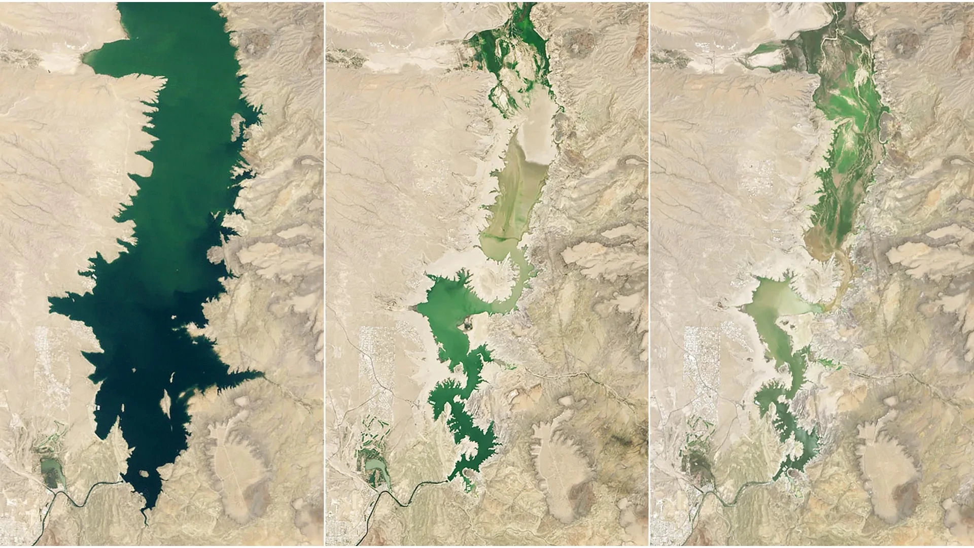
In recent years, however, unusually dry conditions across the expansive Rio Grande basin have placed mounting, unprecedented pressure on those essential water supplies. The entire region has endured a prolonged and severe drought, testing the resilience of local ecosystems and agricultural communities alike. These punishing conditions worsened dramatically when the river’s primary headwaters in the southern Rocky Mountains experienced the earliest snowmelt on record, disrupting the natural seasonal cadence of water flow that downstream users have relied upon for generations.
Together, this lack of winter precipitation and the premature runoff helped push Elephant Butte Reservoir, the largest body of water in New Mexico, down to its lowest level since 1971. When satellite imagery captured the lake, the reservoir held a meager 1.4 percent of its total capacity, painting a stark picture of hydrological distress. By contrast, historical records show the reservoir was nearly full on June 2, 1994, and water levels remained relatively high and stable during much of the period from 1985 through 2000. During another severe drought cycle in the past, the lake had previously reached an annual low of 2.9 percent capacity on July 8, 2013, a figure that now underscores just how severe the current deficit has become.
Elephant Butte Falls to 1.4 Percent Capacity
The extreme decline in water levels exposed vast stretches of lakebed, revealing long-submerged debris along the shoreline and causing thick layers of sediment to cover boat ramps at Elephant Butte Lake State Park, effectively cutting off recreational access for boaters and tourists. Still, hydrologists and state officials noted that the reservoir appeared to have finally reached its lowest point of the year in late July. State officials reported that agricultural water releases officially ended after July 28, marking the conclusion of the heavy irrigation demand season and allowing the reservoir to slowly begin the process of recovering and rising again, albeit from a profoundly depleted baseline.
The persistent and deepening drought has also served to highlight much broader, long-term concerns regarding the future availability of water along the entire Rio Grande corridor. Communities, municipalities, and agricultural water users in both New Mexico and Texas rely heavily on a delicate balance of surface water and groundwater drawn from throughout the valley. Managing those increasingly limited and fiercely contested supplies requires careful, data-driven decisions about how water is stored, allocated, and shared among competing interests, all while the margin for error grows vanishingly thin.
NASA Satellites Help Track a Shrinking Water Supply
To meet these mounting challenges, several sophisticated technological efforts backed by NASA’s Western Water Action Office are actively working to provide regional water managers with significantly better information for making critical allocation decisions. These collaborative projects harness advanced NASA Earth observations and powerful analytical tools to radically improve the scientific understanding of real-time water availability, thereby supporting more efficient and equitable resource distribution across the basin.
One key initiative successfully created a sophisticated predictive model that combines high-resolution NASA satellite measurements of vital factors including surface soil moisture and evapotranspiration rates. The resulting system operates as a near-real-time tool that supplements the traditional water allocation methods and monitoring practices already utilized by the Elephant Butte Irrigation District. By integrating space-based observations with local ground data, water managers gain a clearer, more timely picture of how much moisture is being lost to the atmosphere and how much remains available for crop uptake.
Another related project successfully combined satellite measurements of water surface heights with high-resolution observations gathered from uncrewed aerial drones and specialized instruments deployed directly on the ground. Researchers utilized this multi-layered combination of data to examine closely how regional groundwater pumping influences the overall flow of the Rio Grande. According to the Western Water Action Office, this granular insight helps regulatory officials better understand the complex interplay between surface flows and subterranean aquifers, ultimately aiding them in managing water rights more fairly and sustainably.
Furthermore, NASA scientists are actively participating in a comprehensive federal study focused specifically on the Upper Rio Grande basin. This ongoing work seeks to deepen scientific understanding of the region’s total water needs, accurately estimate how much water resources may realistically be available in the future under changing climatic conditions, and develop advanced data-driven tools to help local managers proactively respond to those escalating challenges.