Despite remaining stubbornly offshore, Hurricane Simon unleashed its fury on Mexico’s Pacific coast, battering the region with destructive winds, heavy downpours, and severe coastal flooding. While emergency management teams on the ground grappled with the immediate threats of rising water and potential landslides, space-borne instruments were recording an entirely different kind of spectacle far above the storm. High in the upper reaches of Earth’s atmosphere, NASA and NOAA satellites captured the extraordinary sight of enormous, rippling waves propagating through the stratosphere and mesosphere—a rare atmospheric phenomenon triggered by the immense energy surging up from the hurricane below.
Hurricane Simon represents the latest chapter in an exceptionally active 2026 Eastern Pacific hurricane season, which has repeatedly tested the resilience of coastal communities across the region. On October 11, 2026, the storm achieved Category 4 status on the Saffir-Simpson hurricane wind scale, moving dangerously close to the Mexican coastline on a north-northwest trajectory. At its peak intensity, Simon generated sustained winds reaching a staggering 250 kilometers (155 miles) per hour, placing it among the most formidable tropical cyclones of the season.
Hurricane Simon Batters Mexico’s Pacific Coast
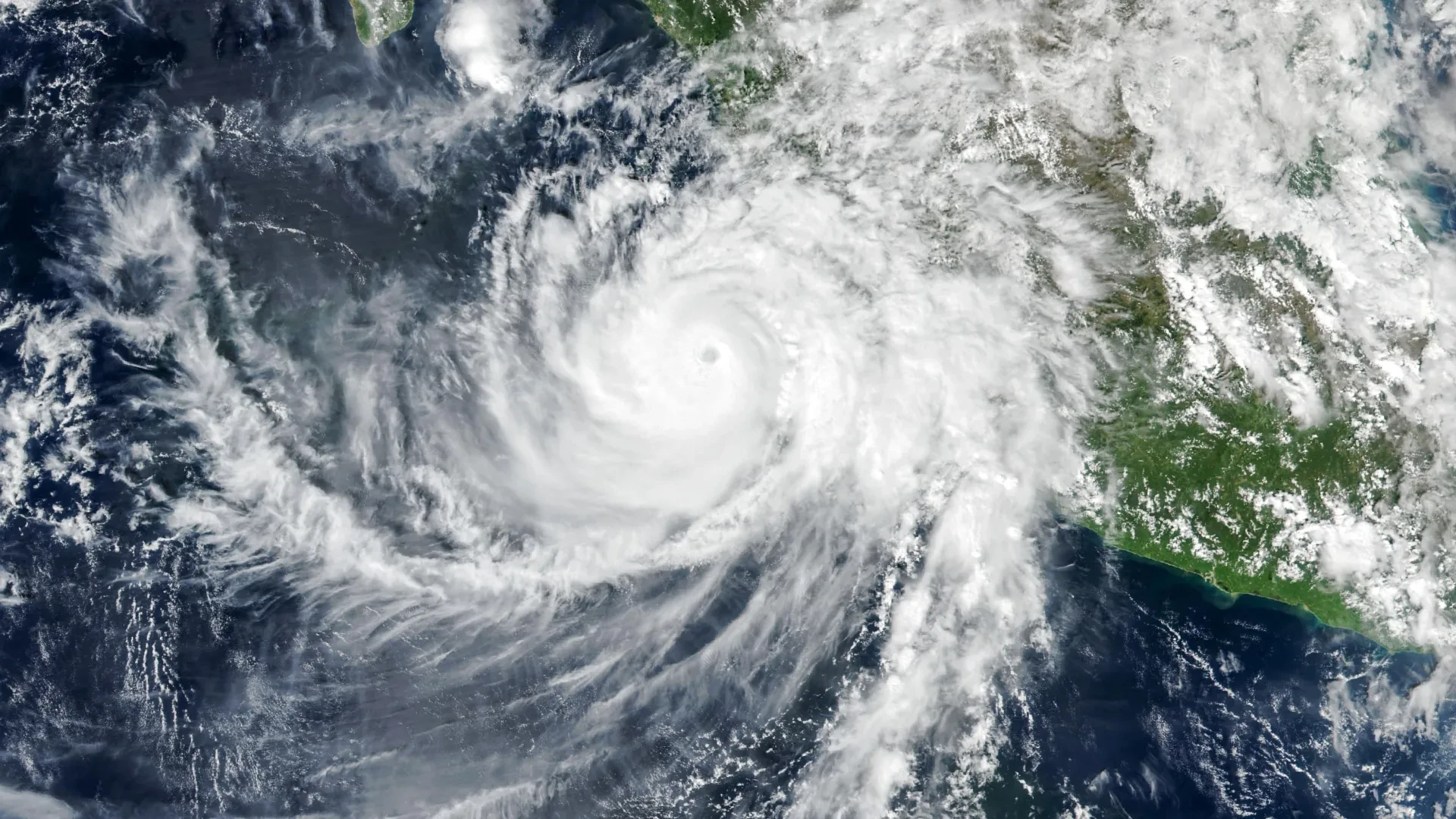
At approximately 2:30 p.m. local time, corresponding to 20:30 Universal Time, on October 11, the Visible Infrared Imaging Radiometer Suite (VIIRS) instrument aboard NASA’s Suomi NPP satellite looked down from orbit to capture a striking, high-resolution image of the massive weather system. At that exact moment, the eye of Hurricane Simon was situated roughly 50 kilometers (30 miles) offshore, hovering precariously between the major coastal cities of Manzanillo and Puerto Vallarta.
According to advisory updates from the National Hurricane Center (NHC), the storm’s maximum sustained winds had eased slightly to approximately 210 kilometers (130 miles) per hour by the time the satellite imagery was acquired. Nevertheless, despite this minor reduction in wind speed, the hurricane’s powerful inner core remained perilously close to land, posing a severe and immediate threat to population centers, infrastructure, and maritime operations along the western coast of Mexico.
As the storm crawled along the coastline, the rugged topography of the Sierra Madre mountain range played a critical role in mitigating its worst-case potential. The towering peaks and complex terrain helped disrupt Simon’s circulation, gradually reducing the storm’s overall intensity and shrinking the geographical footprint affected by its most destructive winds. Even with this natural barrier dampening its power, the hurricane unleashed torrential rainfall and severe coastal flooding across multiple communities, including the vital port city of Manzanillo. Disaster response agencies warned that the unrelenting downpours significantly heightened the risk of dangerous, life-threatening mudslides in the steep, water-saturated mountainous terrain surrounding the coastal corridor.
NASA Captures Strange Waves Above the Hurricane
While the visible effects of Hurricane Simon were causing widespread disruption and anxiety on the ground and across coastal waters, orbital instruments detected an equally fascinating phenomenon unfolding miles above the cloud tops.
During the early morning hours of October 11, the immense thermal and mechanical energy released by the storm generated massive, rippling disturbances that traveled vertically, punching deep into Earth’s upper atmosphere. A detailed nighttime satellite image, captured by the VIIRS instrument flying aboard the NOAA-21 satellite, revealed intricate atmospheric gravity waves spreading outward in concentric patterns from the center of the hurricane.
These complex waves are born from intense convective activity taking place deep within the storm system. In the immediate vicinity of the hurricane’s eyewall, the intense release of latent heat acts as a powerful engine, fueling vigorous convection that forces vast quantities of warm, moist air to surge rapidly upward. This process builds towering cumulonimbus clouds that can pierce high into the troposphere.
The tremendous updrafts and downdrafts churning inside these towering convective structures act like a stone tossed into a pond, disturbing the surrounding air masses and generating atmospheric waves. These disturbances then propagate vertically, traveling upward through the stratosphere and into the mesosphere. Unlike ocean waves, which rely on a liquid medium, atmospheric gravity waves are oscillations of air parcels, where buoyancy and gravity act as the restoring forces that drive the wave motion.
Why the Rare Atmospheric Ripples Were Visible
Although intense tropical cyclones frequently generate atmospheric gravity waves, capturing them from space is an exceptional event. Under normal circumstances, powerful winds and turbulent shearing forces in the upper atmosphere can distort, weaken, or completely disperse these delicate disturbances before they ever reach the mesosphere. It is only when they manage to ascend high enough that they can interact with a phenomenon known as airglow, making their presence visible to specialized satellite sensors.
Airglow is a faint, natural luminescence produced by chemical reactions among gases residing in the upper layers of Earth’s atmosphere. When atmospheric gravity waves pass through this glowing layer of gas, they induce subtle, periodic compressions and expansions that alter the density and temperature of the air. This creates faint variations in brightness, revealing the distinctive ripple patterns of the waves to sensitive space-borne optics.
The day-night band of the VIIRS instrument is specifically engineered to be sensitive enough to detect this extremely faint natural light in the dark of night. However, this high sensitivity comes with a challenge: the sensor also collects moonlight reflected off Earth’s surface and scattered through the atmosphere. This lunar illumination often washes out the much weaker signals of airglow, rendering the subtle atmospheric ripples invisible to satellites.
Fortunately for atmospheric scientists, environmental conditions aligned perfectly during the observation of Hurricane Simon. The region was experiencing very little illumination from the Moon, creating a dark background that allowed the delicate atmospheric ripples to stand out with exceptional clarity. This rare convergence of factors enabled the satellite to capture striking, high-contrast imagery of the upper-atmosphere waves.
Hurricane Simon’s Unpredictable Path Raises Concerns
Back at Earth’s surface, the immediate crisis was compounded by forecasting uncertainty. By the morning of October 13, meteorologists and forecasters at the National Hurricane Center were still struggling to achieve a clear consensus regarding Simon’s future trajectory and potential intensity changes.
In official discussions, the National Hurricane Center characterized its confidence in the storm’s intensity and track forecasts as "very low confidence." This unusual level of uncertainty reflected how persistently Simon had deviated from standard model predictions, repeatedly behaving in ways that defied traditional meteorological expectations.
At that stage in the cyclone’s lifecycle, forecasters were weighing several plausible scenarios, including the possibility that the storm might execute a northward turn, potentially entering the Gulf of California before making a direct landfall on the Mexican mainland.
Regardless of the exact track the storm ultimately decided to take, extensive ocean swells generated by Simon’s massive wind field were projected to create extremely hazardous surf and rip current conditions along substantial portions of southwestern and west-central Mexico over the succeeding days, keeping local authorities and coastal residents on high alert.