On the morning of August 26, a catastrophic flash flood tore through the rugged Himalayan border region shared by Nepal and the Chinese autonomous region of Tibet. The disaster claimed the lives of more than 1,300 people, leaving thousands more missing and triggering widespread devastation across mountain valleys and downstream river basins. In the weeks following the catastrophe, scientists have scrambled to analyze satellite imagery, drone footage, and seismic recordings to reconstruct the sequence of events and understand the powerful natural forces behind the tragedy.
While initial assessments pointed toward a sudden glacial collapse, ongoing scientific analysis has reframed the disaster as a complex "multi-hazard cascade." Researchers have determined that the event was ultimately set in motion by a massive bedrock failure high on a mountain slope, dragging tons of glacial ice and debris down with it.
The disaster has drawn sharp focus from political leaders and climate researchers alike. Nepal’s Prime Minister, Balendra Shah, has publicly described the floods as a stark signal that the environmental risks borne by communities throughout the Himalayan region are escalating rapidly due to changing climatic conditions. Although climate skeptics have attempted to use the initial confusion over the bedrock failure to downplay the influence of global warming, researchers emphasize that while direct attribution of single-event landslides remains challenging, rapid regional warming is demonstrably increasing the likelihood of such extreme geohazards.
What Happened?
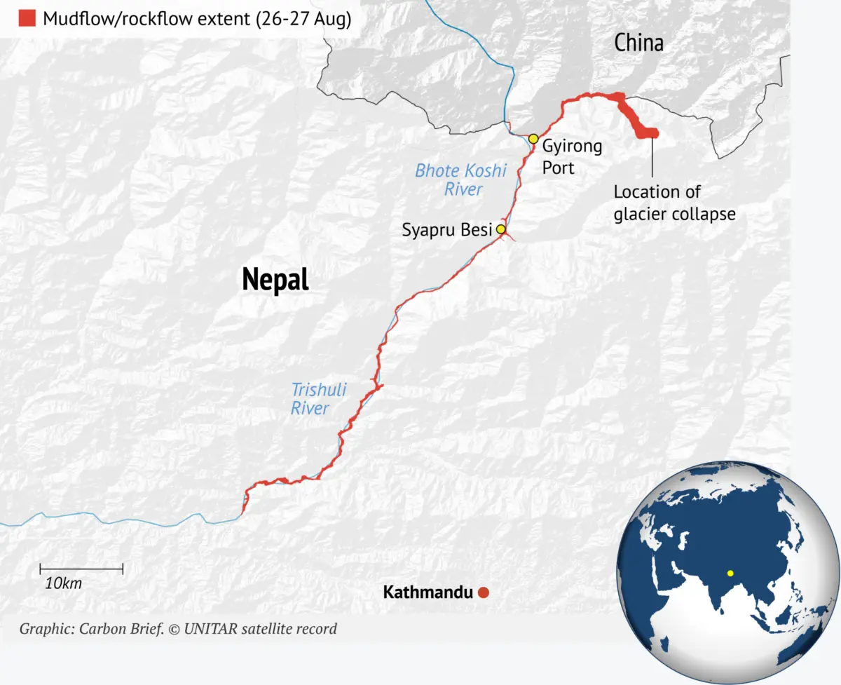
Detailed reports compiled by scientific consortia, including high-mountain experts from the HiRisk group, have outlined the exact progression of the disaster. The sequence began at approximately 8:37 a.m. local time on August 26, when an immense mass of solid bedrock and overlying glacial ice broke away from a slope on the Langtang-Lirung mountain in the Nepalese Himalaya. The mass plunged from an elevation of roughly 5,200 meters above sea level directly down to the valley floor at 3,000 meters.
The impact of the massive landslide generated enough ground shaking to register initially as a magnitude 4.4 earthquake on instruments operated by the US Geological Survey (USGS). Later that day, the USGS clarified that the seismic signature was not tectonic in origin, but rather the result of a catastrophic glacier collapse and debris flow equivalent to a magnitude 5.2 earthquake.
Upon crashing into the valley floor, the avalanche of melting ice, water, and pulverized rock slammed directly into the Lhende Khola, a high-altitude river tracing the border between Nepal and China. Known downstream as the Bhote Koshi in Nepal and the Poiqu or Poqu in Tibet, this vital waterway feeds an extensive network of rivers across the region, including the Trishuli river.
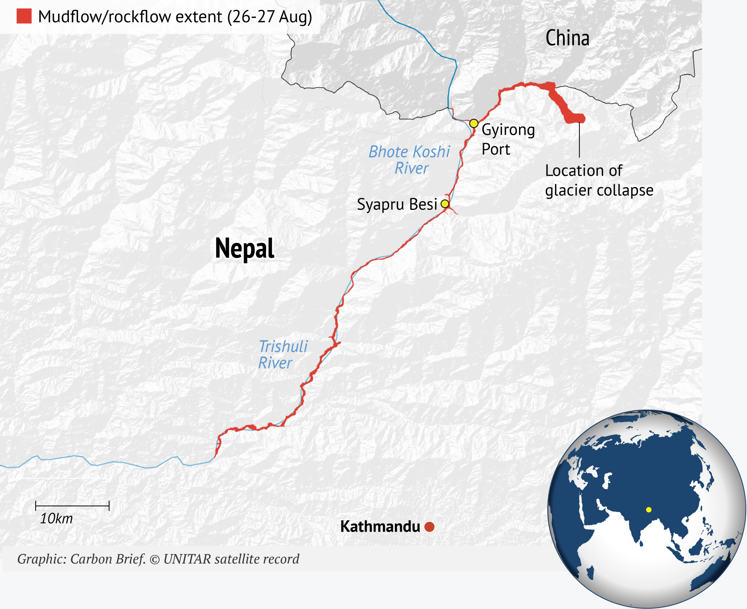
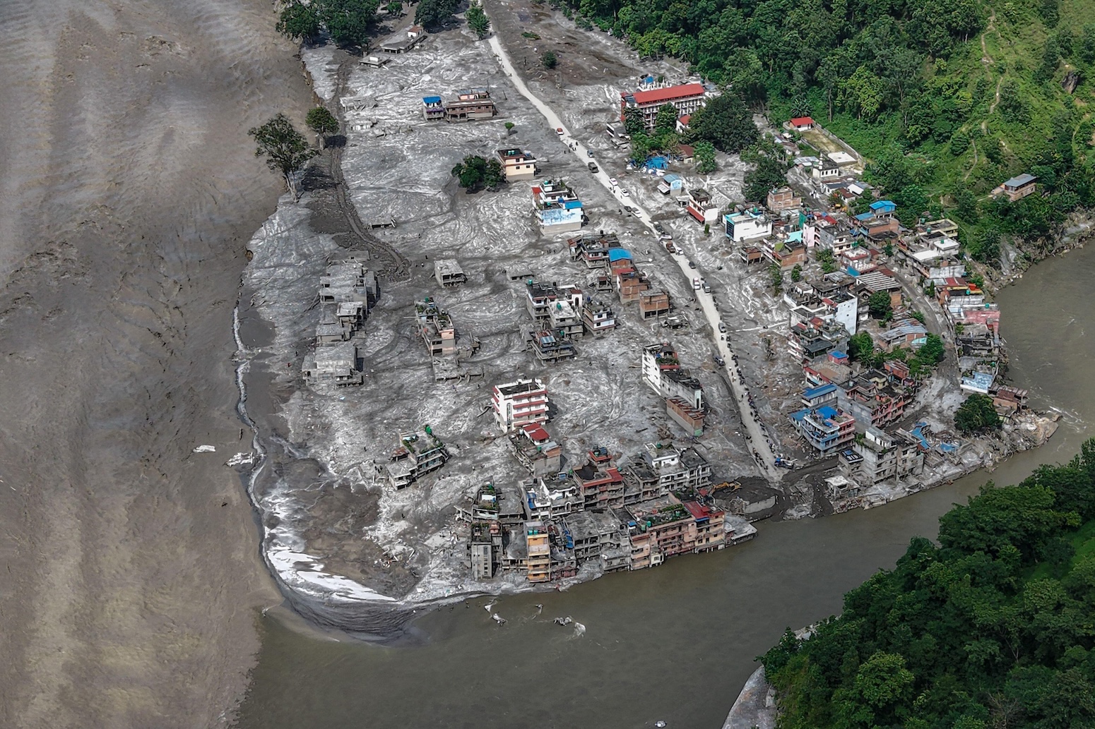
As the torrent surged, a massive debris lake temporarily formed on the valley floor. When this natural dam burst, a towering wall of water, mud, and boulders raced downstream at speeds reaching up to 30 kilometers per hour. The flash flood destroyed settlements, roads, bridges, hydropower infrastructure, and border posts across both Nepal and Tibet, eventually reaching the Nepalese town of Mugling more than 130 kilometers downstream by early afternoon.
Independent reports from hazards researchers noted the staggering scale and speed of the floodwaters. In the Nepalese municipality of Galchhi, the Trishuli river rose by an astonishing nine meters in just 30 minutes. Glaciologists subsequently warned that the danger did not pass with the initial surge. A secondary barrier lake, holding millions of cubic meters of water, formed at a river convergence in Tibet and subsequently burst two days later on August 28, causing secondary river level spikes.
The economic toll of the disaster has been severe. Officials from Nepal’s National Disaster Risk Reduction and Management Authority estimated that property and infrastructure losses exceeded $2.5 billion. Additional expenses required to reconstruct roads, establish temporary shelters, restore drinking water supplies, and rebuild electrical power grids were projected to cost tens of millions of dollars more.
How Did Bedrock Collapse Trigger the Flash Floods?
In the immediate aftermath of the catastrophe, early reports suggested that a collapsing glacier or a tectonic earthquake was the primary catalyst. However, subsequent high-resolution satellite imagery revealed that an enormous chunk of the mountainous bedrock beneath the glacier had given way first.
Geomorphologists studying the site noted that the failure occurred in the solid, hard rock underlying looser geologic layers. Rather than a standalone glacier failure, the mountain slope below the ice gave out, dragging the overlying glacier down with it due to mechanical structural failures that had accumulated over extended periods.
Experts note that failures of deep bedrock in high-mountain environments are becoming increasingly common as rapid deglacierization alters stress patterns on steep slopes. Similar catastrophic events have been documented globally, including the Chamoli disaster in the Indian Himalaya in 2021, a massive landslide in Switzerland last year, and comparable incidents in Alaska.
The presence of buried ice within the valley floor further amplified the disaster. When the initial landslide struck, it interacted with this subterranean ice and meltwater, transforming the rockslide into a hyper-concentrated mudflow that packed lethal destructive power. Without this massive influx of water and mobile debris, the geological event would have remained a localized rock-slope failure rather than a regional humanitarian catastrophe.
How Have Temperatures Risen in the Affected Region?
While global average temperatures have risen by roughly 1.4 degrees Celsius since pre-industrial times, warming is far from uniform across the globe. Mountainous regions, in particular, are experiencing accelerated temperature increases compared to lowland areas.
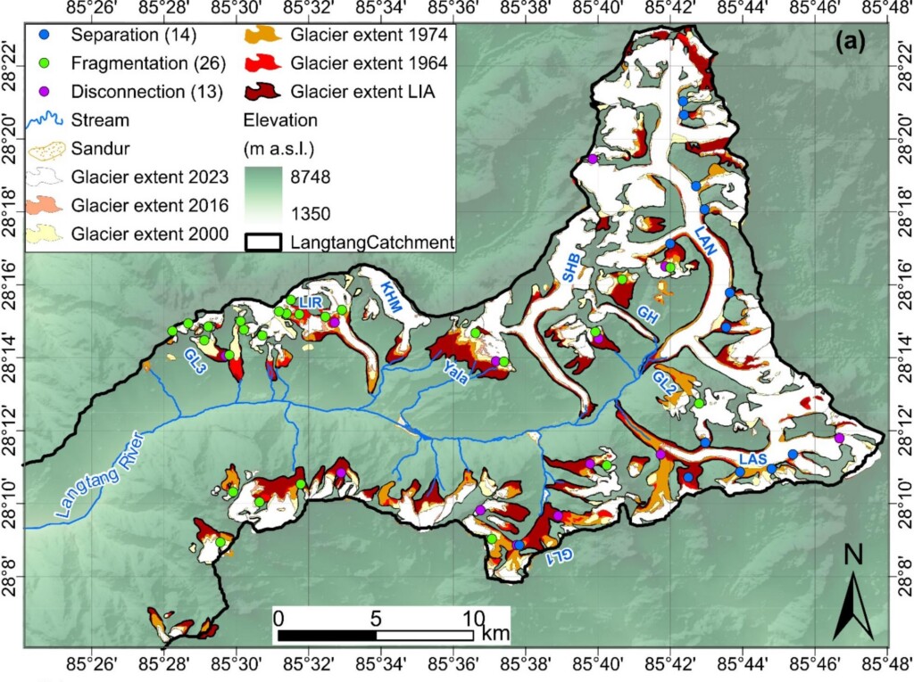
Research focused on the Langtang catchment—a river basin in central Nepal containing extensive glacial coverage—indicates that high-elevation glacial zones situated 4,000 meters above sea level warmed at a rate of 0.31 degrees Celsius per decade between 1960 and 2023. This rate is more than three times higher than measurements recorded at lower-elevation weather stations in the region.
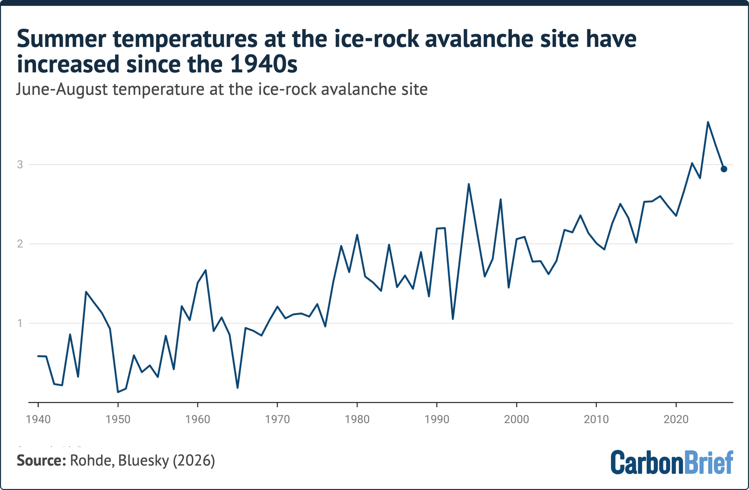
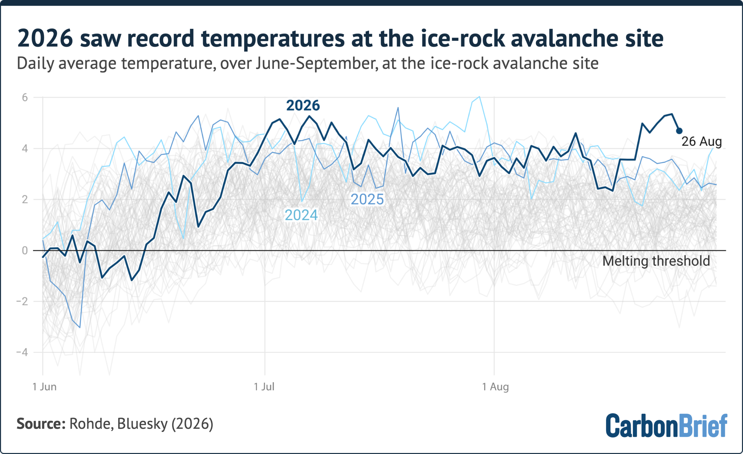
Reanalysis data covering the specific 5,200-meter elevation site of the bedrock collapse shows a clear upward trend in summer temperatures dating back to 1940. The summer months leading up to the August disaster recorded some of the highest temperatures in local observational history. Climate analysts examining daily averages noted that the days preceding the collapse experienced the hottest August temperatures ever recorded at the site, leaving the glacier and underlying rock mass thinned, weakened, and uniquely vulnerable during one of the warmest summers on record.
How Have Rising Temperatures Affected Mountain Stability?
The accelerated warming trend has directly impacted the stability of high-altitude terrain through the thawing of permafrost—ground that remains frozen for consecutive years. Sensors monitored by research teams in the region indicate that permafrost at elevations up to 5,200 meters has been thawing actively for years, transitioning solid rock foundations into fragmented terrain during warm seasons.
This transition creates mechanical stress as frozen and thawed ground interact along disparate densities and movement patterns. Furthermore, permafrost acts as a natural cementing agent, or glue, holding fractured rock faces together. As the permafrost melts, the structural integrity of the rock slope degrades.

The thawing process also introduces liquid water into joints and fractures within the bedrock, generating internal hydrostatic pressure that facilitates structural failure. During the days preceding the disaster, high temperatures drove significant ice and permafrost melt in the absence of heavy rainfall, providing the internal water pressures necessary to trigger the catastrophic slope failure.
How Have Glaciers Retreated in the Affected Region?
Glaciers across the Hindu Kush Himalaya region are shrinking at an accelerating pace. Studies indicate that the rate of glacier retreat in the Himalayas has doubled since the late 20th century, with melting intensifying significantly after the year 2000 alongside elevation-dependent atmospheric warming.
The specific glacier involved in the Langtang-Lirung disaster retreated by approximately 450 meters between 1990 and 2020. Glaciologists explain that this substantial retreat removes the lateral mechanical support that the glacier previously provided to the underlying rock slope. As the ice pulls back, upper rock slopes are left exposed and structurally destabilized.

This widespread shrinkage poses growing hazards to the nearly two billion people living downstream across South Asia, elevating risks associated with both rock-ice avalanches and sudden glacial lake outburst floods.
Can the Event Be Attributed to Climate Change?
In the wake of the disaster, policymakers, media outlets, and environmental campaigners pointed directly to human-caused climate change as the driving force behind the catastrophe. However, physical scientists have exercised caution, noting that rapid rock-ice avalanches involve complex chains of causality and lack the extensive historical observational records necessary for straightforward single-event attribution studies.
Researchers emphasize that slope failures in the Himalaya have occurred naturally for millennia due to the inherent tectonic and geological activity of the world’s highest mountain range. Therefore, the physical mechanics of the bedrock collapse could theoretically occur in the absence of anthropogenic warming.

Nevertheless, the scientific consensus strongly indicates that a changing climate significantly increases the probability of such events. Factors such as accelerated permafrost thaw, extreme summer heatwaves, and long-term glacial retreat all act to prime mountain slopes for catastrophic failure.
To address these complex dynamics, specialized research teams, including the World Weather Attribution service, have conducted rapid analyses focusing on temperature trends in the region. Their findings show that July and August temperatures at the collapse site have increased by roughly 1.5 degrees Celsius due to human-induced climate change, outpacing average global warming rates. While a full attribution analysis of the landslide itself remains beyond the scope of current rapid-response methodologies, scientists maintain that permafrost degradation, glacial thinning, and historical seismic events have collectively pushed high-mountain hazards beyond previous adaptation limits.