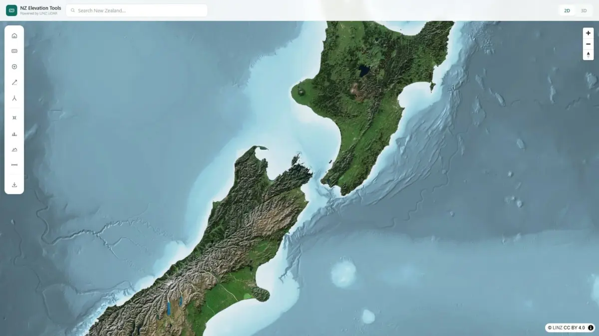
A new browser-based geospatial application, NZ Elevation Tools, has been launched to make New Zealand’s high-resolution elevation data instantly accessible to professionals and outdoor enthusiasts alike. Built directly upon the national Light Detection and Ranging (LiDAR) dataset collected by Land Information New Zealand (LINZ)—widely recognized as the most detailed elevation data ever gathered for the country—the web tool allows users to examine terrain features directly within a standard web browser without requiring specialized Geographic Information System software or heavy data downloads.
The application introduces a fast, interactive mapping environment covering the entirety of New Zealand. By opening the viewer, users can click anywhere on the interactive map to retrieve exact point elevation measurements. Beyond simple point queries, the interface allows users to draw a line across any feature on the landscape—such as a ridge, steep hillside, or river valley—and generate an immediate, dynamic terrain profile. To facilitate comprehensive spatial analysis, the platform also allows users to switch seamlessly between standard two-dimensional views and fully interactive three-dimensional models of the entire country.
The underlying dataset powering NZ Elevation Tools represents a significant milestone in New Zealand’s public mapping infrastructure. For years, government agencies and regional authorities coordinated by LINZ have carried out extensive airborne survey initiatives to map the country’s varied and often rugged topography using LiDAR technology. By emitting rapid laser pulses from airborne equipment to measure precise distances to the earth’s surface, LiDAR captures physical landforms with exceptional accuracy. The resulting data captures fine-grained surface variations, penetrating forest canopies and uncovering micro-topography that traditional mapping approaches often miss.
While LINZ’s national LiDAR coverage has created an extraordinary foundation of geographic data, working with raw elevation datasets has traditionally presented major technical hurdles. LiDAR files are typically distributed as dense point clouds or large raster digital elevation models that frequently span gigabytes or terabytes of storage space. Analyzing these raw files historically required proprietary software suites, high-performance workstation hardware, and technical expertise in spatial data processing. Consequently, the practical utility of high-precision elevation data often remained restricted to specialized spatial analysts and dedicated municipal planning departments.
NZ Elevation Tools removes these accessibility barriers by delivering full nationwide elevation coverage through a fast, web-native interface that runs entirely in the user’s browser. Leveraging modern web rendering engines and streamlined spatial data delivery systems, the tool allows users to perform real-time elevation queries without installing software plugins, managing local file storage, or performing complex spatial processing. The viewer rapidly streams data on demand, providing real-time terrain insights whether a user is looking at urban development zones or remote alpine backcountry.
The availability of a lightweight, highly accurate elevation viewer offers immediate practical benefits across several commercial and professional sectors, particularly surveying and civil engineering. For surveyors and civil engineers conducting initial feasibility studies, accurate preliminary surface data is critical for evaluating site conditions. Rather than relying on generalized topographic contours or organizing initial field measurements prior to baseline planning, engineering teams can use the web interface to verify true surface heights, assess natural slopes, and examine terrain dynamics along potential construction corridors or road alignments.
The application also serves as a practical asset for agricultural land management and rural operations throughout New Zealand. Farmers and station managers routinely manage uneven landforms, complex drainage catchments, and variable slope profiles when planning pasture development, managing soil conservation, and installing water conveyance infrastructure. By drawing elevation profiles across fields and hillside paddocks, rural managers can analyze water flow paths, assess erosion risks, evaluate slope steepness for machinery safety, and determine optimum placement for livestock fencing and access tracks across complex terrain.
In addition to commercial and agricultural applications, the tool directly addresses the needs of New Zealand’s active outdoor community. The country’s wilderness areas, including the Southern Alps and extensive national park networks, present complex and challenging terrain for trampers, bushwalkers, mountaineers, and hunters. Navigating remote backcountry safely requires an accurate understanding of ridge heights, steepness, and elevation gain across proposed routes. Standard paper or digital topographic maps rely on contour lines that summarize elevation changes at fixed intervals, which can obscure small cliffs, hidden gullies, and rapid changes in slope grade.
Through the tool’s line-drawing terrain profiling feature, outdoor enthusiasts can map out planned walking vectors or hunting traverses to view an exact cross-sectional breakdown of the land. The dynamic elevation profile provides immediate clarity on vertical changes, showing exactly how steep a climb will be and where sudden terrain drops occur. Combined with the viewer’s ability to flip between two-dimensional overhead maps and three-dimensional landform representations, field users can evaluate terrain visibility, line-of-sight, ridge heights, and access paths before stepping foot on the trail.
The development of NZ Elevation Tools highlights an ongoing trend within the geospatial domain toward democratizing complex geographic information. The tool was created by Daniel O’Donohue, a geospatial specialist who is also the creator and host of The MapScaping Podcast, a platform focused on geospatial technology and spatial data applications. With a background in spatial analysis, O’Donohue designed the tool to streamline how high-density spatial data is delivered to non-specialist users, transforming massive public datasets into functional, everyday tools.
By converting LINZ’s detailed LiDAR archives into an accessible, browser-native map viewer, NZ Elevation Tools demonstrates how open government spatial data can be unlocked for broad practical use. Whether assisting surveyors with preliminary site evaluation, guiding farmers through rural land planning, or helping trampers analyze steep mountain ridges, the platform connects high-precision elevation data directly to the people who need accurate height information across New Zealand.