Despite remaining offshore, Hurricane Simon battered Mexico’s Pacific coast with powerful winds, torrential rainfall, and severe flooding, leaving coastal communities on high alert during the active 2026 Eastern Pacific hurricane season. At the same time, advanced Earth-observing satellites captured an extraordinary and rarely seen phenomenon high above the tempest: massive, concentric waves rippling through the planet’s upper atmosphere.
Hurricane Simon marked the latest in a relentless series of powerful tropical cyclones to sweep across the Eastern Pacific during the busy 2026 season. On October 11, 2026, the dangerous Category 4 hurricane moved uncomfortably close to Mexico’s rugged coastline as it tracked on a general north-northwestward path. At the height of its initial intensity over open waters, the system packed sustained winds reaching an astonishing 250 kilometers (155 miles) per hour, making it a formidable weather threat.
Hurricane Simon Batters Mexico’s Pacific Coast
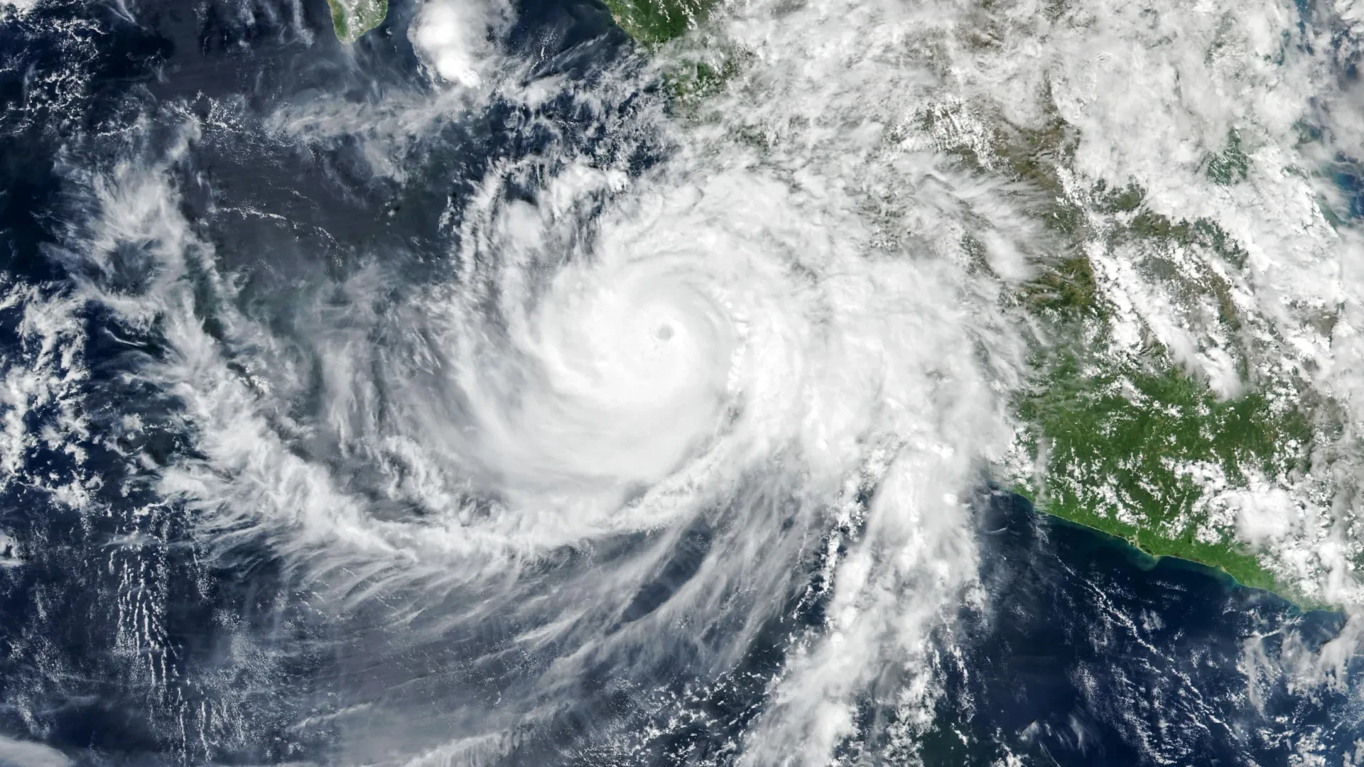
At approximately 2:30 p.m. local time (20:30 Universal Time) on October 11, the Visible Infrared Imaging Radiometer Suite (VIIRS) instrument aboard NASA’s Suomi National Polar-orbiting Partnership (Suomi NPP) satellite captured a striking, high-resolution image of the massive storm. At that exact moment, Simon’s well-defined eye was located roughly 50 kilometers (30 miles) offshore, menacingly positioned between the major coastal cities of Manzanillo and Puerto Vallarta.
According to updates provided by the National Hurricane Center (NHC), the storm’s maximum sustained winds had slightly decreased to approximately 210 kilometers (130 miles) per hour by the time the satellite imagery was acquired. Nevertheless, despite this slight downward trend in peak wind speed, the hurricane’s fierce inner core remained close enough to the shoreline to pose an immediate and severe danger to populated areas along the western coast of Mexico.
As the system crawled northward, the towering Sierra Madre mountain range played a crucial role in mitigating the storm’s full potential. The rugged, elevated terrain acted as a physical barrier that helped limit Simon’s overall strength, reducing the hurricane’s absolute intensity and physically shrinking the geographical area impacted by its destructive gale-force winds.
Even with the moderating influence of the mountains, the storm delivered torrential downpours and widespread flooding to low-lying coastal communities, including the vital port city of Manzanillo. Meteorological authorities and news reports emphasized that the relentless volume of heavy rain drastically elevated the threat of dangerous, fast-moving mudslides and landslides across the steep terrain of the nearby mountainous regions, prompting local emergency management agencies to enforce safety warnings and evacuation advisories.
NASA Captures Strange Waves Above the Hurricane
While Hurricane Simon churned aggressively across the surface of the Pacific Ocean, scientific instruments orbiting hundreds of kilometers above the planet detected something remarkable and ethereal unfolding far above the cloud tops.
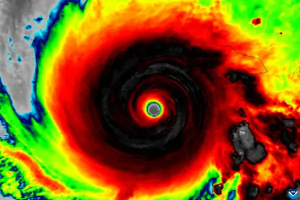
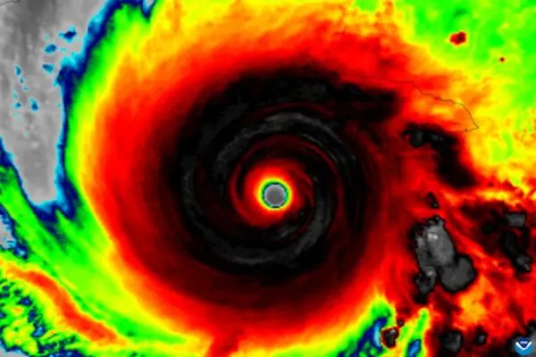
During the early morning hours of October 11, the violent convective activity powering the storm generated rippling disturbances that broke free from the troposphere and traveled far upward into Earth’s upper atmosphere. A detailed nighttime satellite image, captured by the VIIRS instrument flying aboard the NOAA-21 satellite, revealed intricate atmospheric gravity waves spreading outward in vast concentric circles originating from the center of the hurricane.
These complex wave patterns are generated by intense thermodynamic activity occurring deep within the storm system. Near the hurricane’s eyewall, the massive release of latent heat fuels powerful convection, forcing vast quantities of warm, moist air to surge rapidly upward. This violent vertical momentum builds towering cumulonimbus cloud structures that pierce the upper limits of the lower atmosphere.
The powerful updrafts surging inside these towering storm clouds violently disturb the surrounding air masses, generating atmospheric waves that propagate upward into the stratosphere and mesosphere. Unlike familiar ocean waves that move horizontally through a liquid medium, atmospheric gravity waves are dynamic pressure and density disturbances that propagate through compressible air, utilizing gravity as the primary restoring force to push displaced air back toward equilibrium.
Why the Rare Atmospheric Ripples Were Visible
Although powerful tropical cyclones frequently generate atmospheric gravity waves during their lifecycles, orbiting satellites are rarely able to capture them visually. High-altitude winds sweeping through the stratosphere and mesosphere often disrupt, distort, or completely disperse these delicate disturbances long before they can become observable, particularly because they typically require a specific optical phenomenon known as airglow to reveal themselves to spaceborne sensors.
Airglow is a faint, natural luminescence produced by chemical reactions among gases residing high in Earth’s upper atmosphere. When atmospheric gravity waves travel upward and pass through this continuously glowing atmospheric layer, they induce subtle, periodic variations in local air density and temperature. These fluctuations create distinct patterns of alternating brightness and dimming that can outline the otherwise invisible ripple structures.
The day-night band of the VIIRS instrument is exceptionally sensitive, possessing the capability to detect this faint upper-atmospheric light. However, that same high sensitivity creates observational challenges, as the sensor also picks up ambient moonlight reflected off Earth’s surface and lower cloud layers, which can easily wash out and obscure the much weaker luminescence of airglow.
Fortunately, environmental and astronomical conditions aligned in an unusually favorable manner when the satellite observed Hurricane Simon. With minimal illumination from the Moon casting light across the scene, the delicate atmospheric ripples stood out with remarkable clarity against the dark background, allowing the satellite to record the striking ripple formations in unprecedented detail.
Hurricane Simon’s Unpredictable Path Raises Concerns
By the morning of October 13, forecasters and meteorologists at meteorological centers were still grappling with high levels of uncertainty regarding Simon’s future trajectory and potential intensity fluctuations.
The National Hurricane Center explicitly characterized its confidence in the storm’s intensity and track forecasts as resting at "very low confidence," a stark reflection of how the hurricane had repeatedly defied standard predictive models and behaved differently than initially anticipated.
At the time, one primary scenario under consideration by forecasters suggested that Simon might eventually execute a northward turn, potentially entering the mouth of the Gulf of California and threatening a direct landfall further north.
Regardless of the storm’s exact eventual path, massive, persistent ocean swells generated by the powerful hurricane were projected to churn across the open water and slam into portions of Mexico’s southwestern and west-central coastlines over the subsequent days, creating treacherous marine and surf conditions for coastal areas.
NASA Earth Observatory images by Michala Garrison, using VIIRS data from NASA EOSDIS LANCE, GIBS/Worldview, the Suomi National Polar-orbiting Partnership, and the Joint Polar Satellite System.