
From the exclamation marks of Saint-Louis-du-Ha! Ha! in Quebec to the ubiquity of Springfields across the United States, the tiny two-letter municipality of Ea in the Basque Country, or the famously whimsical British road signs pointing travelers toward Ham and Sandwich in Kent, names define human geography. They are fundamental anchors of identity, navigation, and spatial awareness, telling us where we stand, where our communities have been, and where we intend to travel.
Capturing this immense, constantly shifting linguistic landscape is one of the most ambitious undertakings in modern cartography. To date, volunteer contributors to OpenStreetMap, the community-driven global mapping platform, have cataloged more than 115 million geographic names across the planet. Behind this milestone lies an intricate, decentralized data architecture that balances local spoken languages, complex international naming standards, official government edicts, and the practical requirements of digital mapmaking.
The process of recording names is rarely straightforward. Geography is fraught with contested borders, political realignments, regional dialects, and competing historical claims. By relying on a flexible tagging structure and adhering to an empirical "on-the-ground" methodology, OpenStreetMap has established a global database that allows communities to document the world as it actually exists, while providing mapmakers the latitude to render that data to suit virtually any audience.
Local Names and the Fundamental ‘On-the-Ground’ Principle
At the core of OpenStreetMap’s naming conventions is the primary name= tag. Within the project’s data model, this tag is reserved for the primary verbal identifier that people on the ground use to refer to a specific feature. In the vast majority of cases, this corresponds to the most common name spoken in the local language of the territory where the feature is situated.
When a contributor in Paris maps a street, for example, they label it with name=Rue des Beaux-Arts, reflecting the actual signage and daily vernacular used by residents. This convention applies uniformly across every category of spatial feature, ranging from local bakeries and neighborhood avenues to vast lakes, mountain ranges, and international bodies of water. The objective is to record reality rather than impose an external or Anglicized perspective.
To maintain consistency across millions of edits, the OpenStreetMap community has formulated foundational rules. Foremost among them is the "on-the-ground rule," which dictates that map data should reflect verifiable, empirical conditions visible and spoken within the immediate physical environment. Mappers are discouraged from entering theoretical names, speculative titles, or cartographic descriptions in place of genuine toponyms.
The visualization of these names can vary substantially depending on how the underlying data is rendered. Visitors to the main OpenStreetMap website encounter the platform’s default map style, known as "osm-carto." This cartographic style renders the primary name= tag directly onto the map tiles, displaying features in their native local script and tongue. While the site provides an integrated layer switcher allowing visitors to sample alternative rendering styles, the default view deliberately avoids tailoring names based on the visitor’s geographic location or browser language. This design choice is rooted partly in technical efficiency and partly in a commitment to presenting an unvarnished representation of local realities.
Managing Multilingual Realities and Dialects in a Global Database
Human geography is rarely monolingual. A single mountain, river, or public building may carry distinct designations across different cultural, ethnic, and linguistic groups living in the same region, or have widely recognized translations used by international travelers. To accommodate this complexity, OpenStreetMap supplements the basic name= tag with an expansive suite of secondary attributes.
Features can carry dedicated tags denoting historical designations, local variants, official state titles, and informal nicknames. Crucially, any naming key can be modified using standardized ISO language codes. A contributor mapping a major landmark can preserve its native local name under name=, while simultaneously adding name:en= for its English translation, name:fr= for French, or name:de= for German.
This tagging hierarchy extends far beyond basic national languages. The system can handle specific writing scripts, regional orthographies, and distinct geographic dialects. Recognizing that the English spoken in the United Kingdom carries different conventions and terminology from the English spoken in Australia or North America, mappers can deploy regionally targeted tags to capture precise nuances.
The result is a deeply layered database where a single spatial polygon or point can host dozens of valid names simultaneously. While the primary osm-carto style on the website maintains a standardized view showing only the local name=, the platform’s architecture is evolving. Ongoing development on a modernized vector tile layer aims to grant users the ability to dynamically switch the displayed names to their own preferred language. Elsewhere across the broader ecosystem, specialized mapmakers have already produced bespoke styles that filter data to show names exclusively in German, English, or other selected languages.

One Database, Unlimited Maps: The Power of Open Geographic Data
A persistent misconception among casual observers is that the OpenStreetMap website is intended to function as a singular, finished map for general consumers. In reality, the website exists primarily as an operational portal for the contributors who curate the data. The true power of the initiative lies in its role as an open, shared geospatial storehouse.
All data collected by the community is published freely under the Open Database License (ODbL). Under this framework, any individual, public agency, non-profit group, or commercial enterprise can access the database, extract features, and produce customized maps without licensing fees. OpenStreetMap data is routinely integrated into mobile navigation apps, humanitarian relief tools, academic research, logistics platforms, and major commercial video games.
Because the underlying data is disentangled from a single visual presentation, downstream users possess complete creative and editorial control. A logistics firm operating across Europe can design internal maps that prioritize international transportation corridors labeled in a single operational language. A local historic preservation society can build an interactive viewer highlighting historical toponyms that have otherwise disappeared from public road signs. The platform provides the raw, highly structured materials; the end user decides which names to elevate.
When Decrees Meet Common Usage: The Handling of Official Names
One of the most delicate challenges in contemporary cartography occurs when governmental bodies issue official decrees that diverge from everyday vernacular. While a government’s administrative designation frequently matches what citizens actually call a place, political decisions can abruptly introduce new names that conflict with ongoing, widespread public use.
In OpenStreetMap, official designations that differ from popular usage are preserved within the dedicated official_name= tag, rather than overriding the primary name= tag. This distinction prevents sudden administrative edicts from erasing the terms that residents, visitors, and emergency services actively employ on the ground.
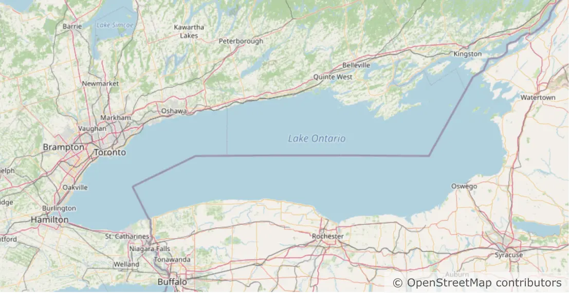
A clear demonstration of this methodology occurred following an executive order concerning Lake Ontario, which led to a targeted community discussion regarding the body of water’s representation. While an official initiative sought to designate the landmark as "Lake America," everyday regional usage overwhelmingly remained "Lake Ontario."
Following active deliberation among community mappers, the lake’s primary designation was retained as name=Lake Ontario, honoring the established linguistic reality on both sides of the border. Simultaneously, the specific US-English administrative designation was integrated through the tag official_name:en-US=Lake America.
This layered approach serves both historical accuracy and practical navigation. By incorporating the secondary tag, applications, search engines, and spatial databases powered by OpenStreetMap can successfully resolve search queries for "Lake America" and guide users directly to Lake Ontario, without misrepresenting the name that millions of people continue to speak, read, and write every day.
A Flexible Architecture for a Complex World
The ability to resolve these linguistic and administrative tensions stems from OpenStreetMap’s decentralized, non-commercial structure. Because the project is maintained by a global public rather than a single corporate entity or state agency, it is not bound to commercial marketing considerations or national political interests.
By anchoring its core practices to empirical observation—verifying what names are actually posted on road signs, printed on municipal directories, and spoken by local populations—the platform maintains a reliable baseline of geographic truth. At the same time, its robust taxonomy of language suffixes and functional tags ensures that official edicts, minority languages, and global translations are documented rather than discarded.
As digital cartography moves deeper into an era of dynamic vector maps, personalized navigation systems, and cross-border data exchanges, the demand for nuanced geographic data will only increase. OpenStreetMap’s flexible architecture ensures that whether an explorer is searching for a major landmark under an official administrative title or navigating past rural road signs pointing toward Ham and Sandwich, the map reflects the world as it is actually known.


