Whether referring to the distinctively punctuated municipality of Saint-Louis-du-Ha! Ha! in Quebec, the dozens of communities sharing the name Springfield across the United States, or the concise coastal enclave of Ea in the Basque Country of Spain, place names serve as the fundamental framework of human geography. They tell us where we are, indicate where we have come from, and guide us toward our destinations. Without names, a map ceases to be a functional guide and becomes an abstract collection of lines, polygons, and coordinates.
Within the collaborative digital ecosystem of OpenStreetMap, the challenge of naming the planet is both an immense technical undertaking and an exercise in community-driven consensus. To date, the project’s global network of volunteer cartographers has cataloged more than 115 million distinct name entries. Every recorded entity—from expansive oceans and international borderlines to neighborhood grocery stores, transit stops, and narrow residential lanes—relies on a carefully structured tagging architecture designed to document the world as it actually exists.
Behind that simple reality lies a delicate balance between local linguistic identity, official government edicts, and international cartographic utility. OpenStreetMap’s methodology reveals how an open-source, crowdsourced database manages geography across borders, languages, and political divides.
Local Name of Features on www.openstreetmap.org
At the core of OpenStreetMap’s philosophy is the documentation of how places are known to the people who inhabit them. In the project’s data schema, this verbal identifier is designated by the primary name= tag. In general practice, this tag is reserved for the most common name of a feature in the local language of the territory where it is situated.
The rule is straightforward in application: cartographers document what a place is called on the ground. If a contributor is mapping a thoroughfare in Paris named Rue des Beaux-Arts, the feature receives the tag name=Rue des Beaux-Arts. This ensures that anyone consulting the primary data layer understands the name as it appears to an observer standing directly in front of the physical street sign.
This principle is directly reflected in the visual presentation on OpenStreetMap’s central portal. While the underlying geographic database supports an endless variety of map styles, the main website displays a default raster style known to the community as "osm-carto." For technical and philosophical reasons, this default view renders the primary name= tag as-is, without altering the text based on the viewer’s physical location, browser settings, or national origin. An English speaker viewing a map of Tokyo or Athens through this layer will see the local Japanese or Greek scripts rather than an automated transliteration.
Maintaining accuracy across more than 115 million entries requires active stewardship. The global volunteer base regularly reviews additions to verify that names accurately reflect current reality, cross-referencing field observations, open public registries, and community consensus to prevent map vandalism, administrative overreach, or cartographic errors.
Additional Names of Features on www.openstreetmap.org
Human geography is rarely unilingual, and places frequently carry multiple names simultaneously. A capital city, a historic valley, or a boundary-spanning mountain range may be known by an official title, an ancient colloquialism, an indigenous designation, and dozens of foreign-language equivalents.
To accommodate this complexity without sacrificing the primacy of the local label, OpenStreetMap implements a granular taxonomy of secondary name tags. These keys categorize names based on their practical function and historical or legal context:
official_name=captures the legally recognized designation established by an administrative body.old_name=preserves historical names that have fallen out of common use but remain relevant for historical research and navigation.alt_name=records accepted alternative names, acronyms, or informal monikers used by local populations.loc_name=documents distinctly localized names that may differ from formal regional nomenclature.
Alongside functional classifications, OpenStreetMap uses standardized international language suffixes. Cartographers can append ISO language codes directly to naming keys to store multilingual variants. For instance, while a feature’s primary name= tag might remain in French, contributors can concurrently add name:en= for the English equivalent, name:es= for Spanish, or name:de= for German.
This linguistic framework is designed to capture regional nuances, distinct writing systems, and specific dialects. Under this model, the database can easily differentiate between the English spoken and written in Great Britain and that used in Australia or the United States. As a result, a single geographic feature in OpenStreetMap often carries a rich metadata profile containing dozens of localized and linguistic variations.
While the default osm-carto style on openstreetmap.org does not dynamically alter its rendering according to user location, alternative styles and external mapping services routinely take advantage of these secondary tags. Furthermore, ongoing technical initiatives within the project, including the active development of vector tile layers for the main website, aim to give users the ability to display maps rendered dynamically in their own preferred languages. Specialized third-party maps already exist that cater entirely to specific linguistic audiences, drawing on OpenStreetMap data to produce atlases rendered entirely in German, English, or other world tongues.

One Database – Unlimited Maps: Create the Map You Want
A frequent point of misunderstanding regarding OpenStreetMap is the conflation of its public-facing website with the entirety of the project. The platform hosted at openstreetmap.org is primarily designed to serve the community of active mappers, offering a reliable reference tool to monitor and verify contributions rather than acting as a rigid, one-size-fits-all commercial navigation product.
The real strength of the project lies in its role as a free, open-access geographic database. Distributed under the Open Database License (ODbL), OpenStreetMap allows anyone—from academic researchers and non-governmental humanitarian teams to commercial software developers and multinational technology corporations—to download, analyze, and render its data without paying licensing fees, provided they adhere to the terms of the open license.
Because the data is structurally separated from its visual representation, developers have complete autonomy over how geographic features are displayed. An organization building a regional public transit app can strip away superfluous consumer data to focus strictly on rail networks and station names. A video game developer can extract road layouts and building footprints to generate synthetic urban environments. Humanitarian agencies responding to natural disasters can highlight damaged bridges and medical clinics while filtering out commercial establishments.
By giving users direct access to raw naming metadata, OpenStreetMap ensures that anyone can construct a customized map tailored to their specific operational, linguistic, or cultural requirements.
What About Official Names?
In many parts of the world, the official name codified by a government agency aligns precisely with the everyday name used by residents. When divergence occurs, however, OpenStreetMap’s commitment to real-world usage creates unique cartographic challenges.
When administrative authorities attempt to impose top-down changes that contrast with everyday reality, the project’s community guidelines prioritize verifiable on-the-ground usage over administrative decree. In such scenarios, the traditional name remains in the primary name= tag, while the legal or administrative variant is assigned to the official_name= key.
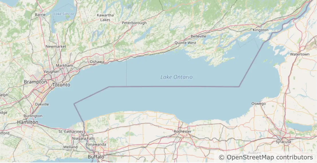
A prominent demonstration of this mechanism arose during public discourse surrounding executive measures concerning Lake Ontario, which prompted discussions regarding the application of the name "Lake America." Following deliberation on the OpenStreetMap community forums, contributors documented the administrative development by assigning the tag official_name:en-US=Lake America to the waterbody’s entry in the database.
However, because the broad English-speaking public and the populations inhabiting the lake’s shores continue to refer to the body of water as Lake Ontario, the primary name= tag remained unchanged.
This dual-tagging approach preserves empirical accuracy without disregarding administrative reality. It also directly benefits digital utility: because search engines, geocoders, and navigational applications built on OpenStreetMap index both primary and secondary attributes, a user entering either "Lake Ontario" or "Lake America" into an OpenStreetMap-powered interface will be directed to the correct body of water without disrupting the primary naming conventions recognized by millions of local residents.
The Name of the Game
OpenStreetMap’s flexible architecture provides a practical solution to one of the oldest debates in cartography: who gets to decide what a place is called. By decoupling the underlying geographic record from any single visual rendering, the project avoids the rigid constraints of traditional, centrally administered atlases.
Through its foundational "on the ground rule," non-commercial structure, and decentralized community governance, OpenStreetMap ensures that its maps remain anchored in direct human observation rather than commercial interests or political expedience. For developers, researchers, and everyday citizens seeking an adaptable, accurate, and globally inclusive record of the world’s places, OpenStreetMap remains a uniquely independent authority in digital cartography.