Grassroots cartographers, open-data advocates, and community organizers from around the world gathered virtually on Saturday, March 28, for the Local Chapters and Communities Congress 2026 (LCCC 2026). Organized under the auspices of the OpenStreetMap Foundation’s Local Chapters and Communities Working Group (LCCWG), the two-hour congress brought together more than 30 participants representing established national chapters, regional mapping collectives, and independent user groups across multiple continents.
The annual congress functions as a dedicated forum for peer exchange within the OpenStreetMap (OSM) ecosystem. It provides a platform where leaders and volunteers—whether formally affiliated with the OpenStreetMap Foundation (OSMF) as recognized Local Chapters or coordinating informal local mapping meetups—can discuss organizational strategies, exchange operational models, and explore mutual solutions to sustain local mapping communities. Attendees joined the session from a diverse array of countries, including Italy, Indonesia, Greece, the United States, Belgium, Kenya, Canada, Brazil, and Malawi, reflecting the global footprint of the open-source geospatial project.
Community Highlights and Grassroots Mapping Initiatives
The congress opened with a global tour of community activities, giving representatives an opportunity to share recent projects, milestones, and localized challenges. The presentations highlighted how OpenStreetMap’s flexible data model is applied to solve distinct geographical, environmental, and cultural needs across different territories.
In Southeast Asia, participants highlighted targeted mapping campaigns addressing critical environmental and linguistic priorities. Representatives from the Philippines described focused initiatives to map rivers and streams, contributing essential hydrological data to aid environmental planning, resource management, and disaster risk reduction. In Indonesia, local contributors focused on mapping toponyms, systematically documenting indigenous and local place names to preserve linguistic heritage and improve cartographic precision in areas undergoing rapid regional development.
European communities also reported notable milestones in both community building and technical coordination. Participants from Spain celebrated the organization of the country’s first national State of the Map (SotM) conference, marking an important step forward for the Spanish community in fostering a unified national network of contributors. In Greece, organizers detailed continuous efforts to expand the active contributor base and improve local infrastructure layers, while mappers from Belgium contributed perspectives on sustaining active user networks within a multilingual administrative landscape.
In North America, grassroots initiatives demonstrated the impact of localized organizing and data interoperability. Contributors from the United States shared the experiences of MapRVA, a local mapping group based in Richmond, Virginia, illustrating how regular, city-scale mapping efforts can tackle neighborhood-level infrastructure needs. Meanwhile, Canadian participants highlighted mapping initiatives in Quebec focused on developing and maintaining spatial datasets in accessible, shareable formats to promote wider reuse among public institutions and local communities.
African mapping groups emphasized community-driven data collection through intensive, hands-on events. In Kenya, organizers continued to utilize collaborative mapathons to train new contributors, mobilize youth networks, and map previously unmapped or rapidly changing regions to support civic infrastructure and humanitarian planning. Representatives from Malawi and Brazil echoed the significance of local engagement, underscoring that direct community involvement remains the foundational element for maintaining accurate and timely open geographic data.
Updates from the OpenStreetMap Foundation Board
Following the community round-up, members of the OSMF Board provided a comprehensive report detailing the foundation’s institutional activities, financial developments, and administrative priorities over the past year.
The board reviewed key milestones from 2025, which saw an expansion in both institutional support and corporate partnerships. The foundation welcomed new corporate members into its network, including spatial computing company Niantic Spatial and the regional administration of Regione Marche in Italy. Financially, the foundation achieved a major breakthrough by securing a €384,000 grant from the Sovereign Tech Fund, an initiative that finances foundational open-source digital infrastructure. This non-dilutive public funding supports the maintenance, stability, and ongoing development of the technical architecture underpinning the global OSM platform.
On the organizational front, the OSMF expanded its network of formally recognized affiliates by officially welcoming AC3 in Colombia as a new Local Chapter. The formal status strengthens the connection between South American contributors and the global governance structure, establishing a recognized institutional counterpart in the region.
Looking ahead, board members outlined several operational and administrative priorities. To manage the increasing complexity of the foundation’s day-to-day work, the OSMF is actively fundraising to establish and finance an additional dedicated operations position. Administratively, the foundation is taking steps to establish a legal subsidiary in Belgium to facilitate European operations, enhance organizational resilience, and simplify cross-border administrative and legal procedures.
Board members are also preparing for an upcoming face-to-face meeting scheduled to take place in Madrid, Spain, where directors will address mid-term strategic planning. Meanwhile, logistical preparations are moving forward for State of the Map 2026, the premier global gathering of the OSM community, which will be held in Paris from August 28 to 30. Attendees of the congress were encouraged to participate in the Paris conference, where the board will host an in-person "Ask Me Anything" (AMA) session to engage directly with contributors and answer community questions.
Overcoming Challenges: Insights from the Open Discussion
The central segment of the congress shifted to an interactive open floor discussion moderated by the LCCWG. Using the interactive presentation tool Menti, organizers collected real-time, asynchronous feedback from participants before opening the floor to deliberate on the systemic hurdles confronting local communities. The discussion was structured around several guiding questions targeting the primary friction points within the global movement.

Barriers for New Contributors
When asked to consider the single hardest barrier confronting prospective mappers, participants emphasized the steep learning curves and social friction that often accompany entry into the project. Contributors noted that confusing technical documentation and the absence of clear, intuitive entry points frequently overwhelm beginners.
Language barriers emerged as a recurring obstacle, particularly for non-English-speaking groups navigating centralized documentation, technical communication channels, and tagging systems that remain heavily dominated by English. Furthermore, several participants raised concerns regarding community culture, observing that newcomers can occasionally feel unwelcome or intimidated when their initial edits are scrutinized or abruptly corrected by experienced contributors without constructive context.
Sustainability and Growth Constraints
Turning to the factors that undermine the growth and long-term sustainability of regional groups, participants pointed directly to resource scarcity and logistical constraints. Finding adequate time and securing predictable funding to organize workshops, manage infrastructure, and conduct public outreach remain persistent struggles for volunteer organizers.
Additionally, community leaders cited geographical fragmentation as a major barrier, explaining that connecting and coordinating isolated mappers across large administrative or geographic regions requires sustained energy that purely volunteer-run groups struggle to maintain over extended periods.
Gaps Between Global Priorities and Local Realities
The consultation probed whether participants experienced a disconnect between the centralized, global structures of OpenStreetMap and the practical realities faced on the ground. Responses underscored a persistent gap between global technical initiatives and localized contributor needs.
While centralized governance often prioritizes high-level technical infrastructure, data licensing issues, and global software engineering, regional communities are frequently consumed with basic operational concerns, such as securing access to local aerial imagery, establishing legitimacy with municipal authorities, and bridging digital divides in areas with limited technical literacy or internet connectivity.
Community Expectations from the OSMF
Participants outlined several specific areas where they believe the OSMF and the broader international network could provide more meaningful support. Direct financial assistance—such as micro-grants for local events, hardware, and travel—was prominently cited as a critical requirement to catalyze local organizing.
Beyond monetary aid, contributors expressed a strong desire for institutional recognition and appreciation of volunteer labor from the global body. Participants called for clearer, more accessible leadership structures and deliberate efforts to foster friendlier, more welcoming community spaces that prioritize psychological safety and collaborative problem-solving over gatekeeping.
Mechanisms for Sustaining Engagement
Despite structural headwinds, participants showcased effective methods they have adopted to maintain unity and engagement within their groups. Informal virtual gatherings, commonly referred to as "mappy hours," were highlighted as effective, low-barrier formats for regular social contact and informal knowledge exchange.
For formal engagement, annual in-person events and localized State of the Map conferences continue to serve as vital anchor points for community building. On an ongoing operational level, organizers rely heavily on mobile chat applications, social media platforms, and focused instant-messaging channels to coordinate daily updates, share announcements, and run peer-to-peer training sessions for both novice and advanced contributors.
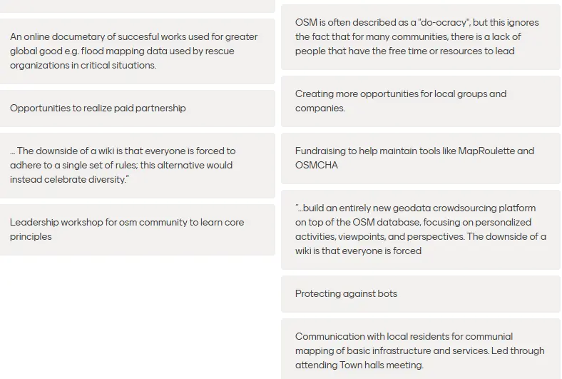
The session concluded with an open ideation exercise collecting broad strategies to protect and expand OpenStreetMap’s volunteer base. These contributions, compiled into visual summaries, reflected an ongoing consensus that lowering technical barriers, decentralizing governance, and investing directly in human networks are essential steps to ensure the sustainability of the global map.
Engaging with the Local Chapters and Communities Working Group
The Local Chapters and Communities Working Group serves as an ongoing conduit for collaboration, ensuring that the dialogue generated during events like LCCC 2026 continues throughout the year. The working group remains open to contributors, community leads, and mapping advocates seeking to share best practices, request guidance on forming recognized Local Chapters, or contribute to policies that support grassroots mapping groups worldwide. Detailed meeting minutes, presentation materials, and full records of the asynchronous discussions from the congress remain accessible to the public via the community’s shared documentation channels.