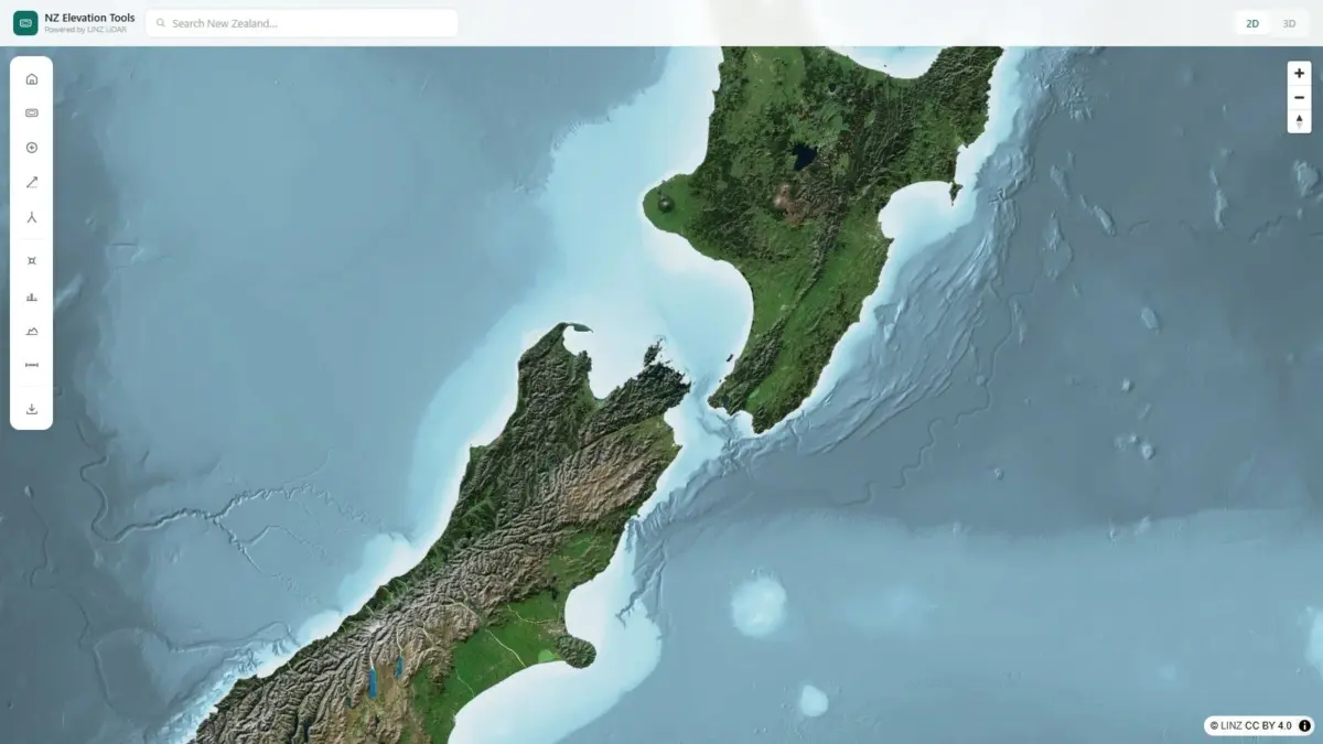
A new web-based spatial application named NZ Elevation Tools has been launched, offering streamlined interactive access to New Zealand’s national Light Detection and Ranging (LiDAR) data collected by Land Information New Zealand (LINZ). Built directly into a standard web browser, the platform allows users across a wide range of industries and outdoor pursuits to explore high-resolution topographic information, extract accurate point elevations, generate real-time terrain profiles, and inspect landforms in both two-dimensional and three-dimensional representations without installing dedicated spatial software.
The underlying elevation foundation of the application is drawn from LINZ LiDAR datasets, which constitute the most detailed elevation data ever collected across New Zealand. LiDAR technology utilizes airborne laser sensors to scan ground surfaces, capturing millions of individual elevation measurements across complex landscapes. While these extensive datasets provide unprecedented topographic precision, raw LiDAR files traditionally require significant computing power, specialized Geographic Information System (GIS) software, and technical data transformation skills to process and interpret effectively.
NZ Elevation Tools addresses these technical barriers by converting complex elevation datasets into an accessible, high-performance web viewer. The platform operates entirely within client-side web browsers, delivering high responsiveness when rendering multi-layered spatial data. Users can navigate across New Zealand’s varied geography, clicking on any specific coordinate to retrieve an exact elevation reading based on official LINZ measurements rather than relying on generalized visual estimates or low-resolution terrain models.
In addition to point queries, the application incorporates an interactive terrain profiling engine. By drawing a line across any section of the digital map, users can instantly generate a detailed cross-sectional profile of the underlying landscape. This functionality displays continuous elevation changes along the chosen path, highlighting changes in gradient, peak heights, valley depths, and structural shifts in terrain. To support different visualization needs, the platform provides continuous switching between planimetric 2D map views and fully interactive 3D terrain visualizations covering the entire country.
The launch of the application targets both technical spatial professionals and general field users who require verified spatial height figures. Among its primary user base are surveyors, civil engineers, primary producers, farmers, trampers, and hunters. Each group stands to benefit from quick, reliable height measurements in field environments or during desktop evaluations where traditional GIS workflows might prove too slow or resource-intensive.
In professional survey and engineering workflows, preliminary site investigations frequently require accurate landform measurements to assess slope stability, identify structural contours, and evaluate regional topography. By providing direct access to LINZ LiDAR figures through an effortless browser interface, initial assessments, scoping studies, and feasibility reviews can be conducted efficiently. The immediate display of exact ground heights reduces reliance on interpolated topographic maps during early planning phases.
For the primary production and agricultural sectors, accurate elevation insights support critical land management decisions. Farmers and rural property managers across New Zealand navigate complex topographic conditions, ranging from low-lying floodplains to steep hill country. Access to exact elevation values and dynamic cross-sectional profiles assists in evaluating surface runoff patterns, identifying optimal drainage routes, planning irrigation infrastructure, positioning fence lines along natural gradients, and assessing slope steepness to prevent soil erosion during land development.
Outdoor recreation in New Zealand’s backcountry—including tramping, alpine trekking, and hunting—demands rigorous spatial planning due to the rugged and often unforgiving nature of the local terrain. Traditional topo maps and static satellite imagery can obscure sharp elevation drops, dense vegetation contours, and subtle ridgelines. By utilizing the terrain profile tool within NZ Elevation Tools, outdoor enthusiasts can analyze proposed routes prior to departure, checking exact ridge heights, identifying severe gradient changes, estimating cumulative elevation gain, and gaining clearer insight into backcountry geography.
The application was created by Daniel O’Donohue, a geospatial specialist and creator of The MapScaping Podcast, an established media platform within the global geospatial community. Leveraging a professional background in spatial analysis and data visualization, O’Donohue developed the browser tool to bridge the divide between complex technical data repositories and end users who require fast, functional insights.
New Zealand’s physical environment presents unique mapping challenges due to its dynamic tectonic setting, extreme elevation variation over short horizontal distances, and diverse terrain ranging from coastal lowlands to towering alpine ranges. Historical national mapping projects often relied on coarse digital elevation models (DEMs) or standard contour lines derived from photogrammetry, which lacked the fidelity necessary to capture localized terrain variations.
The systematic rollout of high-density LiDAR by Land Information New Zealand represented a major advancement in national spatial infrastructure. LiDAR mapping uses airborne laser scanning to penetrate vegetation cover, capturing the true ground surface with sub-meter horizontal and vertical accuracy. This detailed data infrastructure serves vital national interests, including natural hazard modeling, flood risk assessment, forestry management, and regional development planning.
Despite the public availability of LINZ open data initiatives, the sheer volume of high-density spatial files has historically limited direct usage to organizations with dedicated geospatial teams and specialized computing infrastructure. Large file sizes, complicated coordinate reference system transformations, and heavy rendering demands often precluded non-GIS specialists from utilizing the data in everyday tasks.
NZ Elevation Tools resolves these logistical challenges by streaming spatial datasets smoothly in a web browser, handling underlying data transformations transparently. Users can navigate the terrain without downloading multi-gigabyte tile sets or configuring local database connections. The interface balances high-fidelity visualization with light computational demand, ensuring that complex 3D terrain models render smoothly across standard desktop and mobile browser environments.
By integrating two-dimensional spatial context with three-dimensional perspective viewing, the tool helps users interpret complex topography more intuitively. While 2D elevation views provide traditional mapping perspectives suitable for linear distance measurements and spatial orientations, 3D renderings offer an immediate visual grasp of relief, aspect, slope steepness, and shadow effects across mountainous regions, river valleys, and coastal cliffs.
The dynamic profiling tool is particularly useful for analyzing linear corridors across complex ground surface conditions. When users draw a transect across the map interface, the system calculates elevation values along the line, constructing an accurate elevation profile graph in real time. This capability provides instant visibility into topographic barrier height, sightlines, and gradient variations along proposed access paths, pipelines, transport corridors, or recreational trails.
The development of NZ Elevation Tools highlights an ongoing shift within the broader geospatial industry toward light, purpose-built web mapping interfaces. As open data policies increasingly make high-value spatial datasets publicly available worldwide, modern web development techniques enable the creation of specialized software applications that extract real utility from raw geographic data.
By converting LINZ’s detailed LiDAR coverage into an accessible online tool, NZ Elevation Tools demonstrates how open spatial data can be repurposed into intuitive, practical utilities for both professional and public use. The platform offers direct access to New Zealand’s official elevation record, serving anyone who needs rapid, dependable terrain height information across the country’s diverse landscapes.