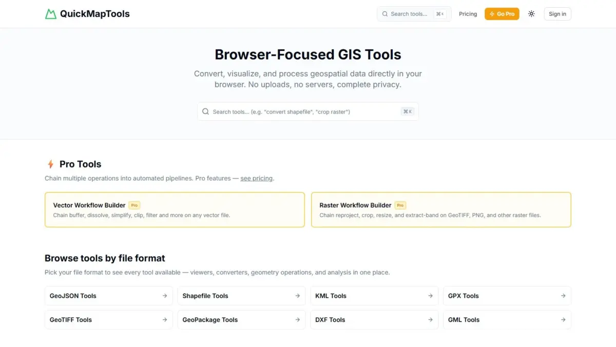
A new web-based geospatial processing tool, QuickMapTools, has emerged to provide broad spatial data operations entirely within modern web browsers without transferring user files to external servers. Designed to eliminate the operational friction of launching full desktop Geographic Information Systems (GIS) software for routine processing tasks, the platform allows users to perform critical geometry manipulations, coordinate transformations, file format conversions, and data visualizations on demand. By leveraging client-side WebAssembly technology, QuickMapTools executes spatial computations directly on the user’s local hardware, guaranteeing that raw geographic data remains contained within the browser session and never leaves the host device.
The browser-focused utility suite caters to a vast spectrum of spatial data structures spanning both vector and raster domain standards. Among the primary supported vector formats are Shapefiles, GeoJSON, Keyhole Markup Language (KML), GPS Exchange Format (GPX), GeoPackage, Drawing Exchange Format (DXF), and Geography Markup Language (GML). On the raster side, the platform integrates full compatibility with high-resolution spatial formats such as GeoTIFF. Through an intuitive interface organized systematically by file format, users can perform fundamental operations—including clipping complex raster layers to specific spatial boundaries, executing buffer operations around vector geometries, converting legacy file types into modern spatial web standards, and reprojecting spatial layers across various coordinate reference systems—all without necessitating software installations, plugin downloads, or cloud server interactions.
The technical architecture underlying QuickMapTools represents a significant shift in how web-based geospatial processing is delivered to end users. Traditionally, browser-based mapping applications operated through one of two models: heavy reliance on server-side processing, where datasets are uploaded to remote servers to execute geometric calculations before returning results, or lightweight client-side JavaScript execution limited in performance and memory capacity. QuickMapTools bridges this gap by deploying WebAssembly, a high-performance binary instruction format designed to run natively inside modern web browser engines at near-native execution speed. By running compiled geospatial libraries directly within the client environment, the platform enables compute-intensive spatial operations—such as calculating complex vector buffers or performing spatial overlays and raster pixel clipping—directly inside the user’s browser runtime.
A central defining feature of the platform is its strict adherence to zero-data-transfer protocols. In conventional cloud-based conversion utilities, users must routinely upload raw spatial files to third-party web servers, exposing sensitive geospatial information to potential intercept risk, regulatory non-compliance, or unexpected data retention policies. QuickMapTools mitigates these operational risks entirely by ensuring that zero bytes of uploaded data are transmitted across the internet. Because file parsing, geometry transformation, raster processing, and file rendering occur entirely in local browser memory, spatial professionals operating under strict corporate governance, non-disclosure agreements, spatial privacy guidelines, or government security mandates can safely process proprietary spatial layers without violating internal data protection protocols or privacy mandates.
Beyond security considerations, the tool addresses a longstanding operational challenge within the geospatial industry: the heavy operational overhead associated with basic spatial tasks. For decades, spatial analysts, urban planners, software developers, and cartographers routinely faced the inconvenience of launching resource-intensive desktop GIS suites simply to carry out trivial operations—such as inspecting a KML file’s contents, reprojecting a Shapefile, or generating a quick buffer around a geometry line string. Desktop applications often require significant system resources, long startup times, and complex menu navigation for elementary tasks. QuickMapTools streamlines these daily tasks into immediate, browser-accessible interactions organized directly around specific file formats, providing instant functionality without system performance degradation or tedious setup procedures.
QuickMapTools is structured around a freemium operational model designed to accommodate both casual spatial users and enterprise power users. The platform’s foundational tools—comprising individual format viewers, file converters, coordinate reprojectors, and basic geometric tools for every major spatial format—are available completely free of charge. For advanced users managing complex or repetitive analytical workloads, the platform introduces a Pro tier. The Pro tier expands upon atomic, single-step operations by offering chained vector and raster workflow pipelines. These pipelines enable users to construct automated, multi-step processing sequences—such as chaining a coordinate transformation to a vector buffer, followed by a spatial clip of a raster GeoTIFF—allowing complex spatial transformations to be executed seamlessly in a single, repeatable workflow right inside the browser environment.
The addition of multi-step pipeline chaining marks a key evolution for browser-native GIS tooling. In traditional desktop environments, repeating complex multi-stage tasks typically required writing custom scripts using external libraries or constructing graphical model builder workflows within software frameworks. By introducing client-side chained pipelines, QuickMapTools allows users to streamline repeatable spatial tasks directly through the browser interface. Users can chain disparate file transformation steps, geometry operations, and raster manipulations into unified processing sequences that execute sequentially on local data. This client-side pipeline model preserves all security benefits of local computation while delivering advanced productivity gains typically reserved for specialized automation scripts or enterprise desktop processing environments.
To appreciate the practical utility of the platform, it is valuable to examine the scope of spatial formats and operations supported across the vector spectrum. Formats such as Shapefile, long regarded as legacy industry standards, often present compatibility challenges for modern web platforms due to multi-file sidecar structures comprising multiple necessary component files. QuickMapTools handles these multi-component structures directly in local memory, allowing seamless conversion into web-native formats like GeoJSON without requiring manual zipping or external server extraction. Similarly, support for XML-based spatial standards—such as KML, GPX, GML, and CAD-derived DXF files—allows users across land surveying, drone navigation, engineering, and web development domains to harmonize disparate data streams effortlessly within a single web workspace.
On the raster side, working with formats like GeoTIFF has historically presented unique technical hurdles due to deep bit-depths, multi-band spectral imagery, and embedded spatial metadata. Web browsers historically lacked native mechanisms to unpack and manipulate large spatial raster layers efficiently without heavy server-side tiling infrastructure. QuickMapTools’ integration of WebAssembly-based raster tools enables users to load high-resolution GeoTIFF datasets locally, inspect pixel values, perform geographic clipping against vector bounding polygons, and export modified rasters directly to disk. This capability brings raster management into line with vector processing speed, giving users a single platform for hybrid spatial analysis tasks.
Another crucial functionality built into QuickMapTools is spatial coordinate reference system transformation. Spatial data captured from field sensors, satellites, CAD software, or open government portals frequently arrives in localized or projected coordinate systems, such as State Plane or UTM projections, which must be reprojected into standard geographic coordinates before web mapping integration. Coordinate reprojection requires precise mathematical transformations that rely on deep projection definitions. By executing coordinate transformations locally, QuickMapTools enables rapid alignment and validation of misaligned geospatial layers, reducing projection errors and simplifying data preparation before integration into larger mapping stacks or database pipelines.
The vision behind QuickMapTools comes from Daniel O’Donohue, a geospatial specialist best known as the creator and voice behind The MapScaping Podcast, an established media platform dedicated to exploring technologies, trends, and methodologies shaping the global spatial community. Drawing on years of professional experience as a geospatial specialist utilizing spatial tools to unravel complex real-world challenges, O’Donohue developed QuickMapTools to address pervasive practical pain points encountered across the industry. His background in host-driven spatial media and broad engagement with cartographers, GIS developers, and spatial data scientists provided first-hand insights into the need for fast, secure, and accessible browser-based spatial utilities that bridge the gap between simple web converters and full-featured desktop software.
The launch of QuickMapTools underscores a broader transformation taking place across the geographical information technology sector. As spatial datasets grow exponentially in size and accessibility, the demand for accessible, high-performance spatial tools that do not rely on centralized cloud infrastructures or cumbersome desktop installations continues to surge. The convergence of modern browser capabilities, compiled WebAssembly routines, and decentralized client-side architecture is redefining how professionals interact with location data. By lowering technical barriers, reducing operational friction, and eliminating cloud privacy risks, platforms like QuickMapTools highlight a future where sophisticated spatial analytics and geometric operations are accessible instantly to anyone with a web browser.
By combining zero-trust local execution with a comprehensive suite of raster and vector processing tools, QuickMapTools offers a pragmatic solution for modern geospatial workflows. Whether performing a quick file conversion, buffering vector features, clipping raster datasets, or building multi-stage processing pipelines through its Pro tier, the platform eliminates unnecessary software friction while maintaining absolute data privacy. As web technologies continue to advance, client-side solutions like QuickMapTools illustrate how high-performance geospatial data processing can become more secure, convenient, and universally accessible across the global spatial community.