As members of the global climate community gathered in London for London Climate Action Week, the severe heatwaves sweeping across Europe served as an urgent reminder of the pressing need for effective climate resilience solutions. Extreme heat has rapidly emerged as one of the most dangerous climate risks worldwide, linked directly to nearly half a million deaths each year. Despite this staggering toll, heat largely remains an invisible hazard in the way governments manage disasters. Unlike a sudden flood or a violent storm, extreme heat arrives without dramatic visual cues, leaving its victims frequently uncounted and policies chronically underfunded.
This policy blind spot is beginning to face pushback in regions heavily impacted by rising temperatures. In India, where heat-related fatalities are projected to escalate sharply by the close of the century, a national finance commission recently recommended that heat and lightning be formally classified as extreme weather events. This proposed policy shift represents a crucial step toward unlocking greater financial investment and establishing strategic coordination for a crisis that has long suffered from a shortage of both.
However, financial resources alone are insufficient without robust systems to ensure funds reach the populations most at risk. Authorities require clear insights into where heat strikes with the highest intensity, who faces the greatest exposure, and how allocated funds are ultimately utilized. To close this operational gap, an innovative tool known as the Intelligent Data Solution for Disaster Risk Reduction (IDS-DRR) has been deployed. Developed collaboratively by the Open Contracting Partnership and CivicDataLab, alongside subject-matter experts and local officials, IDS-DRR was initially engineered to manage spending and mitigate flood risks. Now, the platform has been significantly expanded to cover extreme heat, successfully aggregating fragmented data so that governments can transition from reactive emergency responses to proactive, data-driven climate preparedness.
A Silent Killer Ignored by Traditional Thresholds
A major obstacle in combating extreme heat stems from a historical, one-size-fits-all approach to heat management. In India, traditional national mandates typically trigger official heatwave protocols only when ambient temperatures exceed 40 degrees Celsius. This broad national threshold flattens enormous regional climatic differences and obscures localized dangers.

In the northeastern state of Assam, temperatures rarely climb to that specific baseline, meaning official heatwave days are almost never triggered through standard bureaucratic channels. Nevertheless, the region has experienced significant warming, with at least eight heat-related deaths officially reported between 2024 and 2025. Without a formal heatwave declaration, local officials frequently lack the administrative authority or the financial mechanisms required to deploy emergency resources effectively.
Conversely, in the eastern coastal state of Odisha, temperatures regularly surpass 42 degrees Celsius, but the primary physiological danger is driven by high humidity, creating a severe physical strain that a standard thermometer fails to capture. Furthermore, tracking the exact public health toll remains exceedingly difficult. When an individual with an underlying heart condition passes away during an intense hot spell, authorities can rarely draw a definitive, bureaucratic line back to ambient temperatures. These fatalities accumulate quietly, explaining why heat rarely secures a dedicated budget within traditional disaster risk reduction planning frameworks.
Mapping the Risk and Following the Money
The IDS-DRR platform integrates large volumes of previously fragmented data to map geographical areas facing the highest heat and vulnerability risks, while simultaneously tracking how public funds are deployed to combat them. Having already proven its utility for flood management across Assam, Himachal Pradesh, and Odisha, the platform is now scaling up to cover heat risks across all districts in Assam and Odisha. By unlocking diverse datasets—including meteorological hazard metrics, socioeconomic vulnerability indicators, and public procurement records—the system provides a comprehensive operational overview.
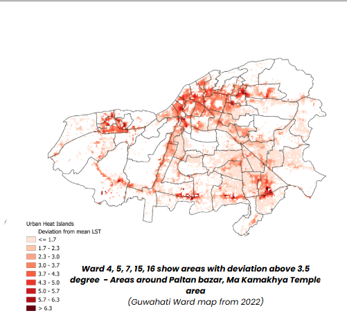
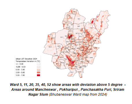
The aggregated data allows analysts to calculate objective indicators of heat risk at the district level, utilizing the established framework of the Intergovernmental Panel on Climate Change. Among the core inputs are two decades of land surface temperature data derived from satellite imagery and transformed into an accessible format. Future plans involve offering more granular analyses at the municipal ward level, where the urban heat island effect becomes prominent. Dense urban infrastructure, concrete surfaces, and limited green cover trap solar radiation, driving local temperatures significantly higher than surrounding rural areas. Static maps illustrating this phenomenon have already been produced for the cities of Guwahati and Bhubaneswar.
Mapping physical hazards, however, represents only part of the solution. The platform also scrapes public procurement portals to monitor government spending patterns. Unlike flooding, extreme heat rarely commands a dedicated budget line, meaning government responses are typically buried across various administrative departments. Much of this spending evades traditional tendering data because heat interventions are frequently ad-hoc and do not necessitate major infrastructure construction. For instance, converting a school into a temporary cooling center during summer holidays is an administrative decision that bypasses standard procurement processes.
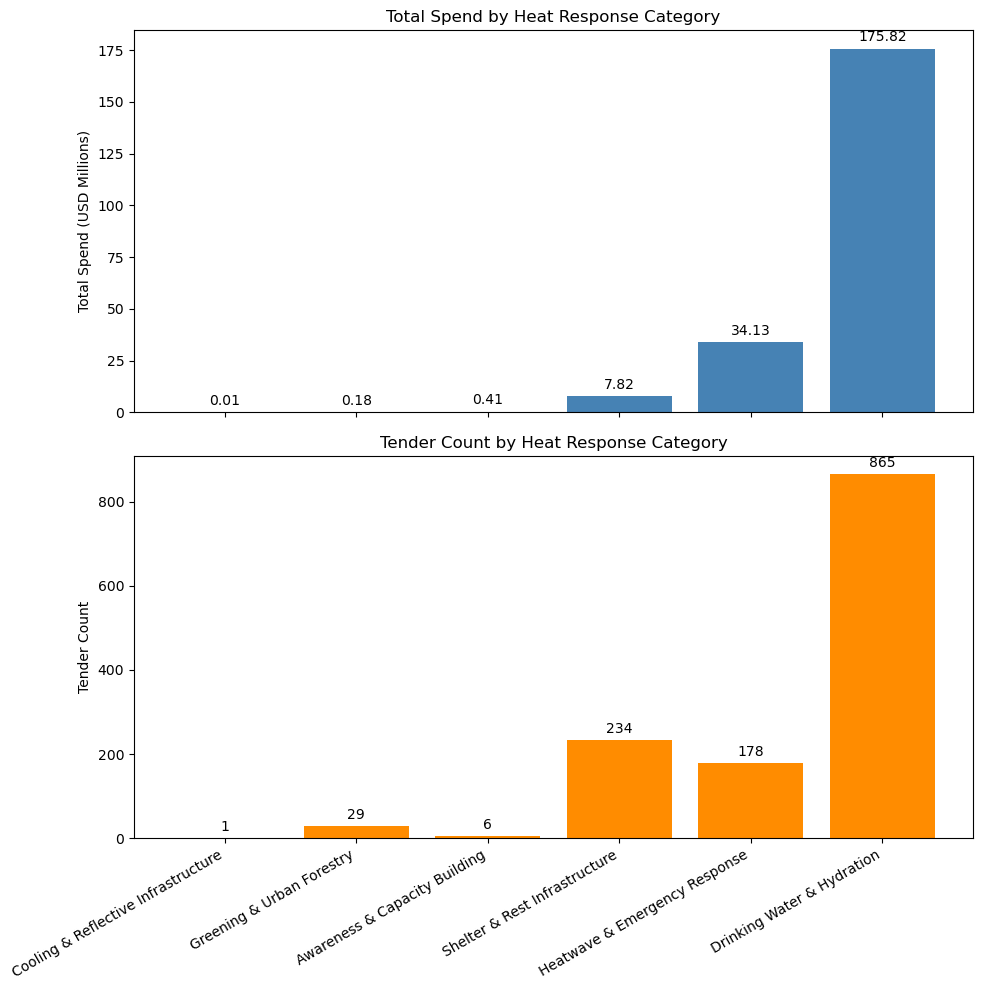
To uncover these hidden expenditures, the IDS-DRR platform employs customized algorithms to cast a wide net across public records. In Odisha alone, researchers identified and tagged 1,313 heat-related tenders valued at a combined US$ 218 million as of May 2026. While many of these projects served broader primary purposes, they addressed heat mitigation indirectly. For example, forestry department plantation projects enhance regional green cover, which subsequently lowers ambient air and surface temperatures.
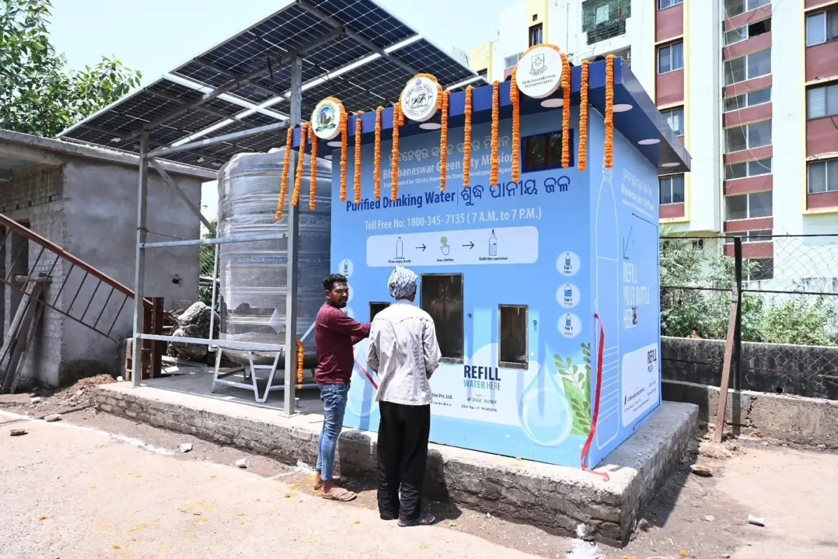
A closer examination of the data revealed that only seven tenders awarded between May and August 2025 explicitly mentioned heatwaves and extreme heat, all of which were designated for temporary shade structures beside busy traffic junctions. An additional 14 tenders spanning from May 2025 to June 2026 focused on the construction of public drinking water kiosks. The ten largest tenders by financial value, all originating in 2021, were dedicated to upgrading municipal drinking water supply systems in major urban centers.
From Ad-Hoc Relief to Targeted Resilience
By overlaying this financial expenditure data with critical socio-economic indicators—such as local population density, healthcare access, and the presence of outdoor laborers—decision-makers can assess risks at a hyper-local level.
This methodology has already demonstrated its effectiveness. When IDS-DRR was initially deployed to address severe flooding in Assam, it assisted state disaster management authorities in identifying ten high-risk districts. Armed with clear, data-driven justifications for resource allocation, officials successfully prioritized seven of those districts with targeted budgets and project approvals in 2025.
For extreme heat management, the platform’s analytical dashboards play an identical role, illustrating how risks have evolved across specific districts and pinpointing where local coping capacities fall short. This empirical foundation guides targeted interventions and optimizes resource distribution.
Insights from the Heat Models in Assam and Odisha
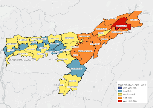
Application of the IDS-DRR model to analyze summer seasons between April and June across Assam and Odisha revealed distinct regional risk profiles. In Assam, Sonitpur emerged as the sole very-high-risk district during the summer of 2025, accompanied by eleven districts classified as high risk. By the summer of 2026, Dibrugarh shifted into the sole very-high-risk position due to recording the highest number of extreme heat days in the state, while ten other districts maintained high-risk status. Sonitpur’s risk classification dropped in 2026 primarily due to a decline in extreme heat days, which fell from 26.63 days down to 11.73 days, thereby lowering the meteorological hazard while underlying exposure and vulnerability metrics remained stable.
In Odisha, eight districts were classified as high risk during the summer of 2025, with none reaching the very-high-risk threshold. By the summer of 2026, Jajapur became the sole very-high-risk district, propelled by a surge totaling 68 extreme heat days. This intensified hazard, combined with persistently elevated exposure and vulnerability risks, drove up the district’s composite risk score, while three other districts remained designated as high risk.
Across both states, the single most significant driver of overall district heat risk was the frequency of extreme heat days, accounting for roughly 50 to 67 percent of the composite risk score in higher-risk districts. However, districts experiencing comparable heat hazards often exhibited vastly different overall risk profiles due to variations in underlying societal vulnerability. For instance, in specific districts of Odisha and Assam, vulnerability indicator scores contributed substantially to overall heat risk, demonstrating that underlying community sensitivities significantly amplify environmental dangers. Conversely, districts with relatively high population exposure but lower vulnerability ranked lower on the risk scale, proving that exposure alone does not dictate overall danger.
Ultimately, these findings underscore that while climatic hazards like heatwaves initiate the crisis, the interaction between physical hazard and societal vulnerability determines whether a district is truly at risk. This nuanced interplay forms the core value of the analytical model in prioritizing localized adaptation interventions.
Complement, Consult, and Collaborate
For practitioners attempting to replicate this data-driven approach, initial strategies should focus on mapping the existing stakeholder ecosystem to identify opportunities for adding value to ongoing initiatives. In Assam, the impetus for extreme heat monitoring originated directly from state officials who were actively formulating regional heat policies amid a growing awareness of severe climate impacts.
The Assam State Disaster Management Authority had previously collaborated on the initial flood risk analytics module, utilizing those insights to refine flood management operations. This established partnership provided a unique opportunity to adapt the platform to inform the state’s heat action plan, ensuring it remained responsive to hyper-local needs while aligning with broader national frameworks. Backed by disaster management leadership overseeing statewide resource allocation, planning, and reporting, the project team successfully integrated new government datasets and developed advanced heat risk analytics.
Furthermore, the initiative helped establish the Assam Heat Action Alliance, a multi-stakeholder forum uniting the disaster management authority, UNICEF, government departments, civil society organizations, and academic institutions to coordinate heat response strategies. In a region lacking a dedicated heat taskforce, this alliance breaks down administrative silos to develop localized action plans, vulnerability assessments, and early warning communication systems designed to protect vulnerable populations. Meanwhile, in Odisha, where a robust heat action plan and advanced technology were already operational, the platform filled a critical gap by improving the delivery of resources directly to affected communities.
A Blueprint for Scalable Solutions
The implications of this collaborative project extend well beyond India. Efforts are currently underway to have the IDS-DRR platform formally recognized as a Digital Public Good for managing flood risks and public spending, a designation that would facilitate the adoption of its underlying architecture by other nations facing similar climate challenges.
The successful integration of heat-risk analytics demonstrates the platform’s inherent flexibility to incorporate new hazards and diverse datasets over time—such as droughts, landslides, and cloudbursts—providing disaster management authorities with a unified decision-support system for multiple climate hazards. As global temperatures continue their upward trajectory, India’s data-driven experiment offers a vital lesson for the international community: combating climate change requires improving analytical knowledge and administrative coordination just as urgently as it demands reducing greenhouse gas emissions.
Support for this pioneering work was generously provided by the Patrick J. McGovern Foundation, a philanthropic organization dedicated to advancing artificial intelligence and data science solutions to foster a thriving, equitable, and sustainable future.