Nearly five decades of continuous satellite observations have revealed a troubling and profound transformation across the Arctic, where sea ice is steadily shrinking in both summer and winter, and much of the remaining ice is growing younger, thinner, and far more vulnerable to seasonal melting.
The Arctic Ocean is covered by a vast expanse of frozen seawater that naturally expands and contracts with the changing seasons. Ice typically builds up throughout the long, dark polar winter, reaching its greatest extent in March before retreating during the warmer, sunlit months to a September minimum. This delicate seasonal cycle has persisted for thousands of years, anchoring the Earth’s climate system and regulating regional temperatures. However, comprehensive satellite measurements reveal that the amount of ice covering the ocean has declined substantially at both ends of this seasonal cycle, signaling a systemic shift in the polar environment.
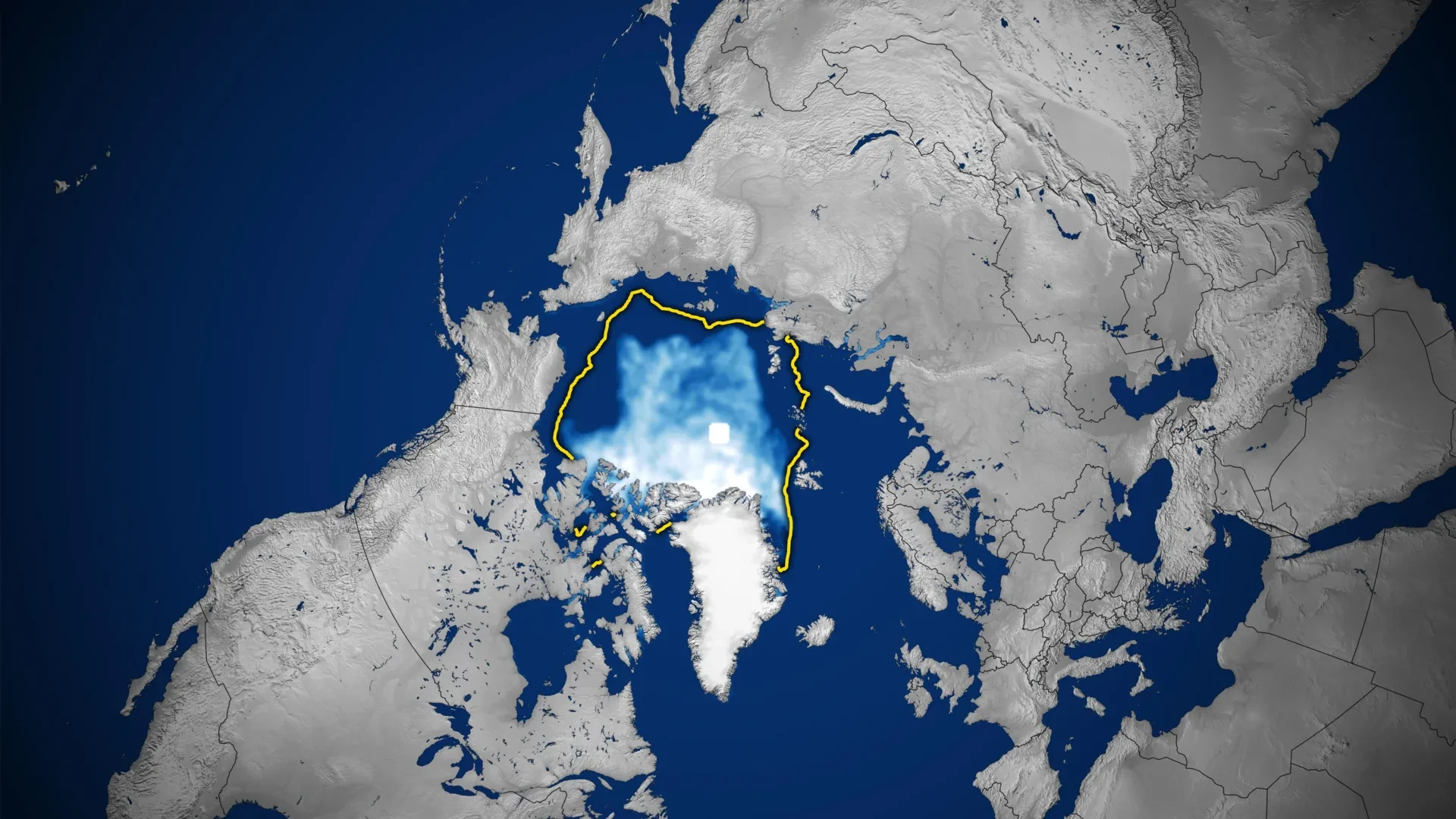
In 2026, Arctic sea ice reached its annual minimum extent on September 12, covering approximately 4.6 million square kilometers, which translates to roughly 1.78 million square miles. According to data released by NASA and the National Snow and Ice Data Center, this latest measurement tied the minimums recorded in 2008, 2010, and 2025, marking it as the tenth-lowest level observed since systematic satellite monitoring began in the late 1970s.
Historical comparisons illustrate the dramatic pace of this environmental change. Sequential analyses mapping September conditions—when ice coverage hits its annual low—against the following March, when it approaches its yearly peak, document a relentless retreat over the decades. This downward trajectory continued straight through to the seasonal cycle concluding in March 2026, underscoring a persistent long-term trend rather than a transient anomaly.
Decades of Arctic Sea Ice Loss
Satellites have continuously tracked the seasonal expansion and retreat of Arctic sea ice since late 1978, providing researchers with nearly five decades of uninterrupted observations. Those meticulous measurements reveal a profound long-term decline that significantly accelerated during the 2000s, leading to a succession of exceptionally low ice levels that shattered historical records.
One particularly striking pattern in the multi-decade dataset is that every single summer from 2007 through 2026 ranks among the twenty lowest September sea ice extents ever recorded in the history of satellite monitoring. Within this bleak modern era, the smallest summer extent ever observed occurred in September 2012, an extreme milestone that caught the international scientific community’s attention.
Despite the overarching downward trend, the rate of summer ice loss has not remained entirely uniform or linear. During the past decade, September sea ice coverage has remained comparatively stable rather than continuing the rapid, aggressive decline witnessed earlier in the century. Scientists emphasize that short-term, localized weather conditions can exert a powerful influence on how much ice manages to survive in any given summer.
For instance, increased cloud cover over the Arctic during recent years has noticeably reduced the amount of direct sunlight reaching the ice pack, helping to limit additional melting and stave off more catastrophic retreats. NASA researchers have identified this atmospheric factor as one key element contributing to the recent temporary stabilization of summer ice minimums. Yet, scientists quickly caution that even with this temporary respite, September ice coverage remains profoundly and persistently far below its historical baseline average.
The Arctic Is Losing Its Oldest, Thickest Ice
The ongoing transformation of the polar region extends far beyond the shrinking geographical area covered by sea ice. Over the same multi-decade monitoring period, scientists have documented a major structural shift in the composition of the ice itself, which is steadily becoming younger, more fragile, and significantly thinner.
Historically, large portions of the Arctic Ocean contained multiyear ice—frozen seawater that manages to survive at least one summer melting season without completely disappearing. Because this resilient ice can persist, accumulate, and compound over multiple years, it typically grows much thicker and more structurally robust than the seasonal ice that forms and melts within a single winter cycle.
Advanced satellite observations now show that this critical multiyear ice has declined significantly over the decades. As a result, the modern Arctic is increasingly dominated by thinner first-year ice. While this younger ice forms readily during the bitter cold months, it possesses far less structural integrity and is vastly more susceptible to rapid melting when the warm summer temperatures return.
This systemic weakening is equally evident during the winter months, a period when Arctic sea ice normally reaches its maximum yearly coverage. In March 2026, the annual winter maximum statistically tied the March 2025 maximum, registering as the lowest winter peak ever documented in the extensive satellite record. This dual failure of ice to adequately recover in winter or maintain its volume in summer points to a compounding vulnerability across the entire polar ecosystem.
Could the Arctic Become Nearly Ice-Free?
Natural climate patterns and internal variability heavily influence Arctic sea ice from year to year, creating short-term fluctuations that can mask or temporarily amplify underlying trends. One prominent example is the Arctic Oscillation, a recurring pattern of atmospheric circulation that dictates temperatures, prevailing winds, and ice dynamics across the entire polar region.
However, researchers stress that natural climate fluctuations alone cannot fully account for the relentless, persistent decline recorded by satellites since continuous monitoring began in 1978. The mounting loss of Arctic sea ice is driven by the broader accumulation of rising global temperatures acting in tandem with natural climate variability, creating an environment increasingly hostile to persistent sea ice.
Looking ahead toward the future, climate scientists project that the Arctic Ocean could become essentially free of sea ice during the summer months at least once before the middle of the 21st century. Such an unprecedented ecological event would mark a profound and historic transformation in a region that has maintained extensive, year-round seasonal ice cover for millennia, altering global weather patterns, ocean circulation, and native ecosystems.
How Satellites Track Arctic Ice Through Clouds
Scientists measure and monitor Arctic sea ice coverage using specialized satellites equipped with passive microwave sensors. These sophisticated instruments are designed to detect microwave energy that is naturally emitted by the Earth’s surface, allowing researchers to accurately distinguish frozen seawater from the surrounding open ocean regardless of lighting conditions.
Because sea ice emits a measurably higher amount of microwave energy than liquid water, it produces a clear, recognizable contrast in satellite observations. Unlike standard visible-light imaging, which is easily blocked by darkness or bad weather, microwave measurements can effortlessly penetrate dense cloud cover. This technological capability makes it possible to monitor the remote Arctic consistently and reliably, even when severe storms or persistent clouds completely obscure the surface from view.
The continuous satellite record began in late 1978 with the launch of NASA’s Nimbus-7 spacecraft, which established the foundational baseline for polar observation. Additional high-resolution observations followed from the Defense Meteorological Satellite Program beginning in 1987, alongside NASA’s Aqua satellite, which provided crucial measurements between 2002 and 2011.
In 2025, researchers further expanded their observational toolkit by incorporating data from the Japan Aerospace Exploration Agency’s GCOM-W satellite, seamlessly continuing the long-running scientific effort to measure ongoing changes in the planet’s polar ice caps.
These satellite mapping products traditionally contain a distinctive white circular region located directly at the North Pole, frequently referred to by researchers as the "pole hole." This visual gap represents an area located beyond the historical viewing angle and coverage limits of the satellite sensors, where direct, continuous measurements were historically unavailable. When scientists calculate the total global sea ice extent, standard scientific protocol involves assuming this unmeasured region remains fully covered by ice, ensuring consistency across decades of climate tracking.