Despite maintaining a menacing track just offshore, Hurricane Simon unleashed a powerful combination of destructive winds, torrential rainfall, and coastal flooding along Mexico’s Pacific coast during an unusually active tropical cyclone season. While emergency responders and coastal communities grappled with the immediate terrestrial threats posed by the storm, scientists high above the planet were documenting an entirely different kind of spectacle. Advanced NASA satellites gazing down from orbit captured an extraordinary view of enormous, ripple-like disturbances propagating through Earth’s upper atmosphere directly above the hurricane, offering a rare glimpse into the complex atmospheric mechanics that link severe weather on the ground to the edge of space.
Hurricane Simon formed as part of a relentless series of powerful tropical systems that swept across the Eastern Pacific throughout the 2026 hurricane season. By October 11, 2026, the storm had intensified into a formidable Category 4 hurricane, tracking north-northwest and moving dangerously close to Mexico’s heavily populated and vulnerable coastline. Sustained winds near the center of the hurricane reached an impressive 250 kilometers, or 155 miles, per hour at its peak, putting regional emergency management teams on high alert as the massive circulation approached the mainland.
Hurricane Simon Batters Mexico’s Pacific Coast
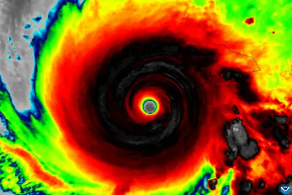
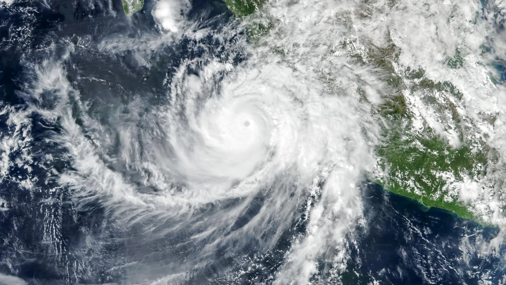
At approximately 2:30 p.m. local time, corresponding to 20:30 Universal Time, on October 11, the Visible Infrared Imaging Radiometer Suite instrument aboard NASA’s Suomi NPP satellite locked onto the massive storm system. At that precise moment, Simon’s distinct eye was located roughly 50 kilometers, or 30 miles, offshore, positioning the core dangerously close to the coastal cities of Manzanillo and Puerto Vallarta.
According to updates issued by the National Hurricane Center, sustained winds had decreased slightly to approximately 210 kilometers, or 130 miles, per hour by the time the satellite imagery was acquired. Even with this slight downward trend in peak wind speeds, the hurricane’s formidable inner core remained close enough to pose an immediate, severe threat to coastal communities, forcing evacuations and putting local infrastructure to the test.
As the storm crawled parallel to the shoreline, the rugged topography of the Sierra Madre mountain range played a crucial role in mitigating its worst-case impacts. The towering terrain disrupted the low-level circulation, helping to limit Simon’s maximum strength and physically shrinking the geographical area impacted by its most violent winds. Nevertheless, the storm’s extensive rainbands brought relentless downpours and severe flooding to coastal settlements, including the vital port city of Manzanillo. News reports highlighted that the continuous inundation significantly elevated the risk of dangerous, life-threatening mudslides and landslides across the steep, saturated slopes of the neighboring mountainous regions.
NASA Captures Strange Waves Above the Hurricane
While Hurricane Simon churned across the surface of the Pacific, generating massive ocean swells and hammering the coast, orbital instruments detected a wholly unexpected phenomenon unfolding far above the cloud tops.
During the early morning hours of October 11, the violent convective activity within the storm generated powerful rippling disturbances that broke free from the troposphere and traveled hundreds of kilometers upward into Earth’s upper atmosphere. A detailed nighttime satellite image captured by the VIIRS instrument aboard the NOAA-21 satellite revealed distinct atmospheric gravity waves spreading outward in concentric ripples from the center of the hurricane.
These fascinating atmospheric features are born from extreme thermodynamic and mechanical activity deep within the tropical cyclone. In the immediate vicinity of the hurricane’s eyewall, the massive release of latent heat acts as a powerful thermodynamic engine, fueling intense convection. This process forces massive quantities of warm, moist air to surge upward at incredible speeds, rapidly developing towering cumulonimbus clouds that penetrate high into the atmosphere.
The violent updrafts generated inside these towering storm clouds act like a stone tossed into a still pond, disturbing the surrounding air masses and generating waves that propagate upward into the stratosphere and mesosphere. Unlike traditional ocean waves, which move horizontally through liquid water, atmospheric gravity waves are oscillating disturbances that travel through compressible air, with the downward pull of gravity acting as the essential restoring force that keeps the waves moving.
Why the Rare Atmospheric Ripples Were Visible
Although intense hurricanes frequently generate atmospheric gravity waves, capturing them from space remains a rare occurrence because satellites cannot always detect the subtle atmospheric signatures. Strong, chaotic winds circulating at high altitudes can easily shear, weaken, or completely disperse these delicate disturbances long before they ascend to the mesosphere. It is only when the waves reach these extreme altitudes that they can become visible to orbital instruments through a complex natural phenomenon known as airglow.
Airglow is a faint, persistent luminescence produced by chemical reactions among gases high in Earth’s upper atmosphere. When atmospheric gravity waves ascend and pass through this glowing layer, they compress and decompress the air, creating subtle, alternating variations in brightness that reveal the distinctive ripple patterns of the waves below.
The day-night band of the VIIRS instrument possesses the extraordinary sensitivity required to detect this faint atmospheric light. However, that same high sensitivity means the sensor also captures background moonlight reflected off Earth’s surface and scattered by the lower atmosphere, which can easily wash out the much weaker airglow and render the ripple patterns invisible.
Fortunately, environmental and astronomical conditions aligned in a uniquely favorable manner when the satellite passed over Hurricane Simon. With very little illumination from the Moon interfering with the nighttime observations, the delicate atmospheric ripples stood out with exceptional clarity against the dark backdrop, allowing the satellite to record the striking patterns in unprecedented detail.
Hurricane Simon’s Unpredictable Path Raises Concerns
By the morning of October 13, meteorologists and forecasters at the National Hurricane Center were still grappling with high levels of uncertainty regarding Simon’s future trajectory and ultimate intensity.
The National Hurricane Center explicitly characterized its confidence in the storm’s track and intensity forecasts as "very low confidence," underscoring how Simon had consistently defied standard meteorological models by behaving in unexpected and erratic ways. At that stage in the storm’s lifecycle, one prominent forecasting scenario suggested that Simon might eventually curve northward, push into the confined waters of the Gulf of California, and make a direct landfall on the mainland.
Regardless of the storm’s exact eventual path or whether it crossed land, the expansive, powerful ocean swells whipped up by the hurricane were projected to generate hazardous, life-threatening surf conditions along large stretches of Mexico’s southwestern and west-central coastlines for several days following the initial encounter.
NASA Earth Observatory images by Michala Garrison, utilizing VIIRS data sourced from NASA EOSDIS LANCE, GIBS/Worldview, the Suomi National Polar-orbiting Partnership, and the Joint Polar Satellite System.