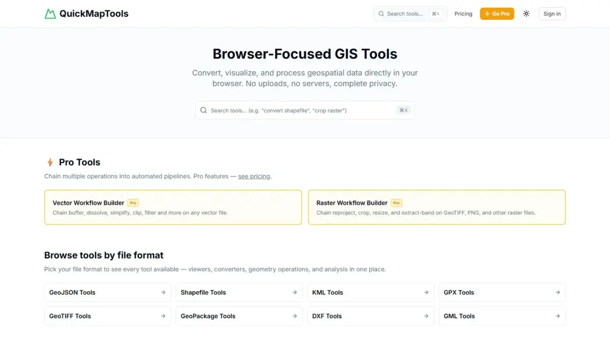
In an era where geographic information system (GIS) workflows increasingly rely on either heavy desktop software suites or remote cloud platforms that require uploading data to third-party servers, a new web-driven solution has emerged to streamline spatial data tasks directly inside the browser. QuickMapTools, a browser-focused platform created by geospatial specialist Daniel O’Donohue, offers professionals the ability to view, convert, transform, and manipulate spatial datasets without installing native desktop applications or transmitting data across external networks.
The core technology powering QuickMapTools is WebAssembly, a low-level binary instruction format that allows code written in high-performance programming languages to execute directly inside modern web browsers at near-native speed. By shifting computational processing from centralized external servers or traditional desktop runtimes into client-side browser windows, QuickMapTools performs complex spatial operations locally on the user’s computer. Spatial analysts, data engineers, cartographers, and urban planners can execute tasks such as converting vector file formats, clipping raster datasets, generating spatial buffers around features, and executing precise coordinate rejections and transformations without relying on external web servers.
A primary pillar of the platform is its explicit guarantee of client-side data privacy. Conventional online file converters and cloud-based spatial platforms typically require users to upload their spatial files to remote servers, where the backend infrastructure processes the file before generating a downloadable output. This multi-step client-server roundtrip introduces potential security risks, bandwidth bottlenecks, and regulatory hurdles, particularly for organizations handling sensitive spatial data. Proprietary corporate boundaries, confidential municipal infrastructure mapping, private environmental survey data, and classified government spatial databases often cannot be uploaded to unverified third-party cloud tools due to strict compliance standards and data governance frameworks.
QuickMapTools addresses these privacy and compliance challenges by ensuring that user data never leaves the local device. Because every operation runs locally within the browser sandbox via WebAssembly, not a single byte of spatial information is uploaded across the network during processing. This zero-upload architecture guarantees that sensitive geospatial datasets remain entirely under the control of the user, allowing professionals working in sensitive sectors to conduct routine format conversions and geometric operations while adhering strictly to local data security policies.
The spatial industry has historically been fractured by a vast array of file specifications, creating persistent interoperability challenges for specialists who must move data between proprietary GIS software, open-source mapping packages, computer-aided design (CAD) systems, field collection units, and modern web mapping interfaces. QuickMapTools addresses this format fragmentation by establishing a universal browser hub that supports every major geospatial format across both vector and raster spatial paradigms.
The application handles widely adopted web formats such as GeoJSON, alongside legacy industry standards like the Esri Shapefile. It also provides seamless compatibility with open geospatial exchange specifications, including Keyhole Markup Language (KML) and the GPS Exchange Format (GPX), both of which are frequently utilized in drone mapping, field navigation, and consumer location tracking. For enterprise spatial databases and CAD workflows, the platform provides support for GeoPackage formats, Geography Markup Language (GML), and Drawing Exchange Format (DXF) files. On the raster side of the spatial spectrum, QuickMapTools processes heavy grid formats such as GeoTIFF, enabling users to manage continuous spatial imagery, elevation models, and remote sensing layers directly within their browser environment.
For GIS practitioners, routine micro-tasks often present unexpected friction in daily operational workflows. Performing simple, repetitive tasks—such as buffering a road network represented in a GeoJSON file, clipping a digital elevation model GeoTIFF to a specific study area, converting a GPX track log from a field team into a clean Shapefile, or converting coordinate reference systems—traditionally requires launching comprehensive desktop software packages like QGIS or ArcGIS Pro. While desktop GIS applications remain essential for deep spatial modeling and advanced cartography, opening a heavy desktop software suite merely to execute a minor data prep step can consume valuable time and computational resources.
QuickMapTools acts as an immediate, lightweight utility kit designed to eliminate this operational overhead. Its integrated visualization tools allow users to instantly inspect vector geometries and inspect spatial layers in the browser window before applying transformations. Geometry tools within the platform allow users to perform core spatial operations—such as calculating proximity buffers around points, lines, or polygons—and apply spatial masks or clipping boundaries to raster surfaces on demand. By providing an instant web interface for these everyday geospatial utility tasks, the toolkit reduces software switching overhead and speeds up overall spatial data preparation pipelines.
To accommodate varying operational needs, QuickMapTools operates on a freemium platform model. The core tools—enabling standalone format conversions, basic coordinate transformations, visual inspection, and single geometry operations—are made freely accessible to users. For advanced users seeking more sophisticated data manipulation capabilities, the platform introduces a Pro tier focused on workflow automation.
The Pro edition expands upon individual conversion tools by introducing chained vector and raster workflow pipelines. In complex geospatial data processing, spatial data preparation rarely consists of a single isolated step; analysts often need to clean, transform, manipulate, and export data across sequential processing stages. The Pro pipeline capability allows users to build multi-step automated sequences within the browser environment. For example, a user can configure a continuous pipeline that converts an incoming vector file, transforms its coordinate reference system, applies a geographic buffer, and uses the resulting geometry to clip an adjacent raster layer in a single, repeatable execution job. This automated chaining mechanism offers data engineering efficiencies without requiring users to write custom Python scripts or install command-line tools like GDAL.
The development of QuickMapTools stems directly from the practical industry experience of its creator, Daniel O’Donohue. As a seasoned geospatial specialist and the creator and host of The MapScaping Podcast—a prominent audio publication dedicated to exploring trends, technologies, and methodologies within the global geospatial community—O’Donohue has spent years examining how spatial technology is applied to solve complex real-world problems. His work across spatial analysis, podcasts, and community education has consistently highlighted the demand for modern, accessible, and secure tools that simplify daily spatial workflows.
Through discussions with hundreds of GIS professionals, software engineers, cartographers, and industry leaders, O’Donohue identified a recurring gap between massive enterprise GIS installations and simple, secure file manipulation tools. QuickMapTools was developed specifically to bridge this gap, translating deep industry domain knowledge into a practical, browser-native utility suite that emphasizes privacy, speed, and cross-format versatility.
The launch of QuickMapTools reflects a broader shift within the global geospatial ecosystem toward decentralized, browser-native computing. As web technologies continue to mature, the traditional boundary between desktop-bound geospatial processing software and light web mapping viewers is dissolving. Technologies like WebAssembly enable developers to compile established, robust C++ and Rust spatial libraries directly into web-executable modules, placing high-grade spatial computation engines directly into standard internet browsers.
By taking full advantage of these client-side execution capabilities, QuickMapTools provides spatial analysts, surveyors, cartographers, and web developers with a secure, versatile environment for handling spatial data tasks. Whether working with complex vector structures like GeoJSON and Shapefiles or dense raster imagery like GeoTIFFs, users can execute essential spatial transformations and workflow pipelines instantly while maintaining absolute control over data privacy.